

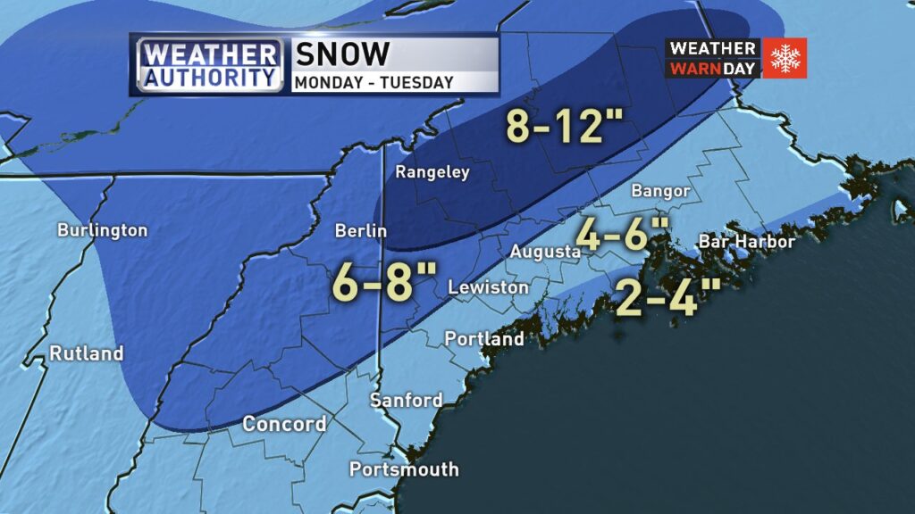
WGME map
With the winter weather worsening and causing slick roads and dangerous driving conditions, I am closing state offices at 3:00 p.m. today to ensure that all state employees are able to get home safely. We will continue to monitor the weather as it develops throughout the evening. pic.twitter.com/Kz3ZJRS7Dy
— Governor Janet Mills (@GovJanetMills) December 30, 2019
UPDATED 1:11 P.M.: Lewiston declared a parking ban from 12:01 a.m. to 8 a.m. Tuesday.
UPDATED 9:43 A.M.: Snowfall reports from the National Weather Service at 9:24 a.m. Monday:
Androscoggin County
SE Poland: 3.2″
W Lisbon Falls: 2.5″
Lisbon: 2.0″
Lisbon Falls: 2.0″
E Lewiston: 1.8″
Auburn 2.1 NNW: 1.7″
Turner: 0.5″
Oxford County
Bethel: 1.5″
Hartford: 0.1″
PUBLISHED 7:37 A.M.: A two-part weather system that arrived early Monday will linger for two days, dropping snow, sleet and freezing rain over most of the state by the time it ends on New Year’s Eve.
The storm dumped more snow earlier than expected in Southern Maine and speeds were reduced to 45 mph for the length of the Maine Turnpike on Monday morning. A coating of snow was left in the Lewiston-Auburn area.
Here's our latest thinking on the event. Southwest NH has the best chance of seeing significant ice accumulation up to around 1/3". A mix with or changeover to sleet is likely for many folks. Still expecting a two part event, with a change to rain possible near the coast Tuesday. pic.twitter.com/KxoEv97gPf
— NWS Gray (@NWSGray) December 30, 2019
Forecasters at the National Weather Service office in Gray described the winter storm as “complex,” but are confident that nearly all the state will see some form of precipitation by the time it is over.
Part one of the storm began late Sunday night, with York County feeling the brunt of its effects. The storm could change to freezing rain and sleet in the southwestern part of the state. Portland will also see some snow accumulation overnight and into Monday. Saco saw snow accumulations of 4 inches or more Monday morning.
Part two brings widespread snow across Maine by Monday night and will last through the day Tuesday, according to WGME forecasts.
Inland and mountain communities can expect almost all snow. Cities like Lewiston and Augusta should see several inches, around the 3-6-inch range. Higher elevations will see the most with around 6-12 inches for the mountains, according to WGME forecasts.
For the coast, some rain and snow will mix Monday evening, then likely all rain by Tuesday morning. There is a chance for some sleet or icy conditions Monday evening mixing in with snow. The coast can expect very little accumulation, just an inch or two at the most as this turns mostly to rain for places like Portland, according to WGME forecasts.
Stacie Hanes, a meteorologist with the National Weather Service, is forecasting that the precipitation will end around 6 p.m. Tuesday – the start of New Year’s Eve celebrations.
“Most of Maine will see snow,” Hanes said.
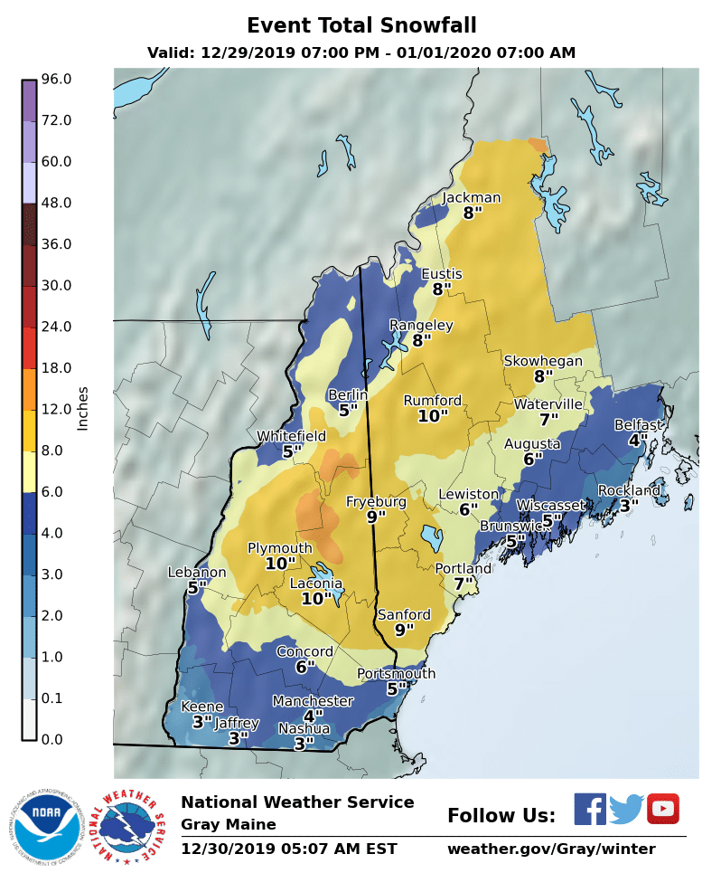
National Weather Service map
Send questions/comments to the editors.

Success. Please wait for the page to reload. If the page does not reload within 5 seconds, please refresh the page.
Enter your email and password to access comments.
Hi, to comment on stories you must . This profile is in addition to your subscription and website login.
Already have a commenting profile? .
Invalid username/password.
Please check your email to confirm and complete your registration.
Only subscribers are eligible to post comments. Please subscribe or login first for digital access. Here’s why.
Use the form below to reset your password. When you've submitted your account email, we will send an email with a reset code.