


A blast of warm air could raise temperatures in southern and central Maine well above 50 degrees by Saturday afternoon, but a dramatic swing is expected to produce icy conditions in interior areas on Sunday.
National Weather Service, Gray
Temperatures across much of the state will climb into the mid-50s on Saturday. In Portland, the temperature could approach the record high of 55 for Jan. 11, according to the National Weather Service.
“It will feel quite warm out there,” said Michael Ekster, a senior forecaster at the weather service office in Gray. “(Saturday) is going to be in the 50s pretty much everywhere, which will melt some of that snow.”
After a warm day Saturday, cold air will move in from the north and east Saturday night into Sunday, changing rain over to freezing rain and sleet for interior Maine and extreme northern New Hampshire. In southern and coastal areas, it will be rainy through midday Sunday, Ekster said.
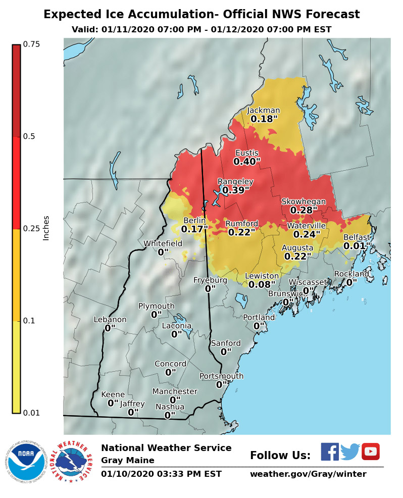
The National Weather Service issued a winter storm watch for parts of Oxford, Franklin, Somerset, Androscoggin and Kennebec counties.
Ekster said the western mountains and foothills could see up to a third of an inch of ice Saturday night into Sunday, but significant icing is unlikely because the front will move through quickly.
“Our best shot at the icing areas is really going to be from the Rangeley area southeast to northern Waldo County. We could see some minor icing in Lewiston and Augusta,” he said. “It could be enough to break a few branches and cause some power outages.”
Ekster said the temperature swing between the Portland area and southern York County and seacoast New Hampshire will be interesting to watch on Sunday.
“It’s quite possible the temperature in Portland could be 35 or 36 degrees,” he said. “A trip down the Maine Turnpike to Kittery and Portsmouth and you could see it in the 60s.”
Sunday won’t be a total washout for southern Maine, where rain will likely end by midday, Ekster said.
The Maine Emergency Management Agency has been preparing for potentially danger ice conditions across portions of the state late Saturday night and Sunday. Acting Director Peter Rogers said MEMA has been coordinating with partners at the weather service, Department of Transportation, county emergency management agencies and electric utilities to prepare for the storm.
During power outages, residents should call their town office or 211 for sheltering and warming center locations, according to MEMA.
Send questions/comments to the editors.

Success. Please wait for the page to reload. If the page does not reload within 5 seconds, please refresh the page.
Enter your email and password to access comments.
Hi, to comment on stories you must . This profile is in addition to your subscription and website login.
Already have a commenting profile? .
Invalid username/password.
Please check your email to confirm and complete your registration.
Only subscribers are eligible to post comments. Please subscribe or login first for digital access. Here’s why.
Use the form below to reset your password. When you've submitted your account email, we will send an email with a reset code.