

WGME map
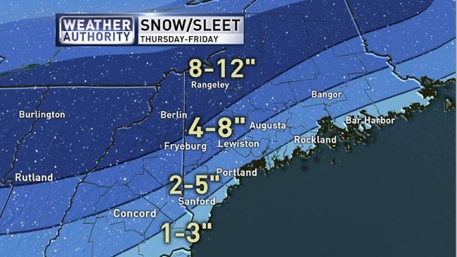
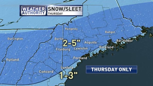
After plenty of sun Wednesday, Thursday and Friday will be messy.
The snow is expected to develop between 5 a.m. and 8 a.m. Thursday. As warmer air moves in aloft, a change to sleet is likely over southern parts of Maine.
WGME map
On Thursday night, expect a lull with only light wintry mix.
On Friday, the primary concern will be freezing rain, and sleet looks likely as well — which could lead to slippery travel and power outages.
The mountains should experience mostly snow from this storm — maybe more than 10 inches in spots.
The sun will make a welcome return on Saturday with colder temperatures.
Copy the Story LinkSnow moves into the region beginning after midnight tonight from southwest to northeast. Snow will mix with sleet, freezing rain, and rain Thursday in southern areas but remain all snow to the north. Below is our expected storm total snowfall and ice accumulations. #mewx #nhwx pic.twitter.com/JwBJ4FupG1
— NWS Gray (@NWSGray) February 5, 2020
Send questions/comments to the editors.

Success. Please wait for the page to reload. If the page does not reload within 5 seconds, please refresh the page.
Enter your email and password to access comments.
Hi, to comment on stories you must . This profile is in addition to your subscription and website login.
Already have a commenting profile? .
Invalid username/password.
Please check your email to confirm and complete your registration.
Only subscribers are eligible to post comments. Please subscribe or login first for digital access. Here’s why.
Use the form below to reset your password. When you've submitted your account email, we will send an email with a reset code.