

The 2020 Atlantic hurricane season has already set records for being so active, with Hurricane Isaias being the earliest ninth named storm on record. Now, the National Oceanic and Atmospheric Administration is predicting that many more records may fall in the coming months, as the Atlantic hurricane season cranks out at least another 10 to 15 named storms.
The updated outlook, released Thursday, calls for a total of 19 to 25 named storms (winds of 39 mph or greater), of which 7 to 11 are expected to become hurricanes (winds of 74 mph or greater), including 3 to 6 of those could become major hurricanes (winds of 111 mph or greater). This update covers the entire hurricane season, which ends Nov. 30, and therefore includes the nine named storms to date.
About 95 percent of hurricanes and major hurricanes form during the August through October period, said National Weather Service director Louis Uccellini during a press conference call. Uccellini said this is one of the most active hurricane outlooks NOAA has ever issued.
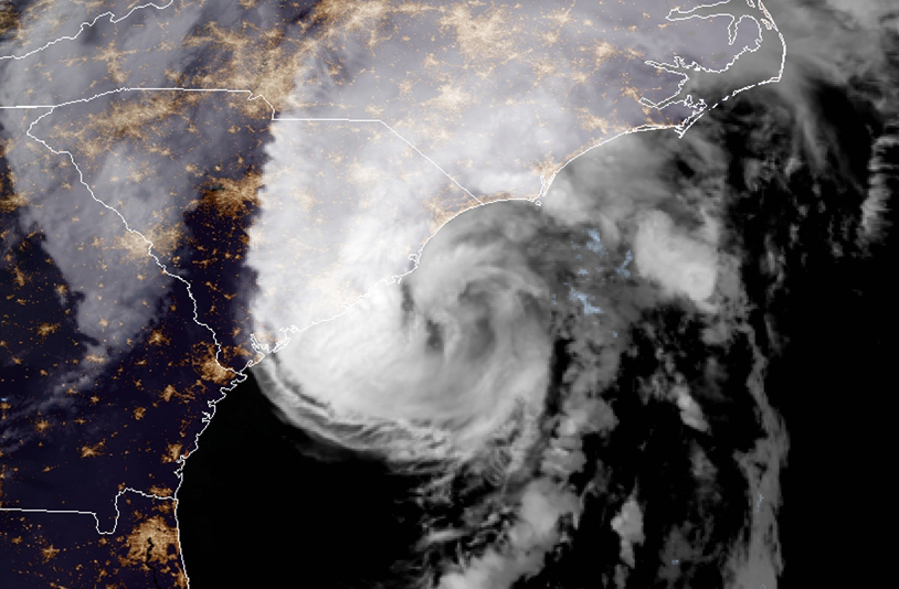
Hurricane Isaias over the Carolinas at 9:00 p.m. on August 3. NOAA
It would only take 21 named storms before all the names on the Atlantic list, determined ahead of time by the World Meteorological Organization, is exhausted and forecasters would resort to using the Greek alphabet. This only happened once before, in 2005, a devastating season that holds the record for being the most active.
The updated outlook is a sharp increase from NOAA’s initial prediction, released in May, which called for a 60 percent likelihood of an above-average season, with a 70 percent chance of 13 to 19 named storms, six to 10 of which will become hurricanes. Three to six of those could become major hurricanes of Category 3 intensity or higher, NOAA predicted.
Now the chance of an above average season has increased to 85 percent, with just a 5 percent chance of it being below average. An average season produces 12 named storms and six hurricanes, three of which intensify into major hurricanes.
The new projections come a day after meteorologists at Colorado State University released their own updated hurricane outlook, which also projects so many storms that, by the end of the season, names would have to be pulled from the Greek alphabet to keep track of them all.
The CSU team predicts the 2020 season will see 24 named storms, including 12 total hurricanes and 5 major hurricanes. The forecast was a significant increase from its previous outlook, issued in early July.
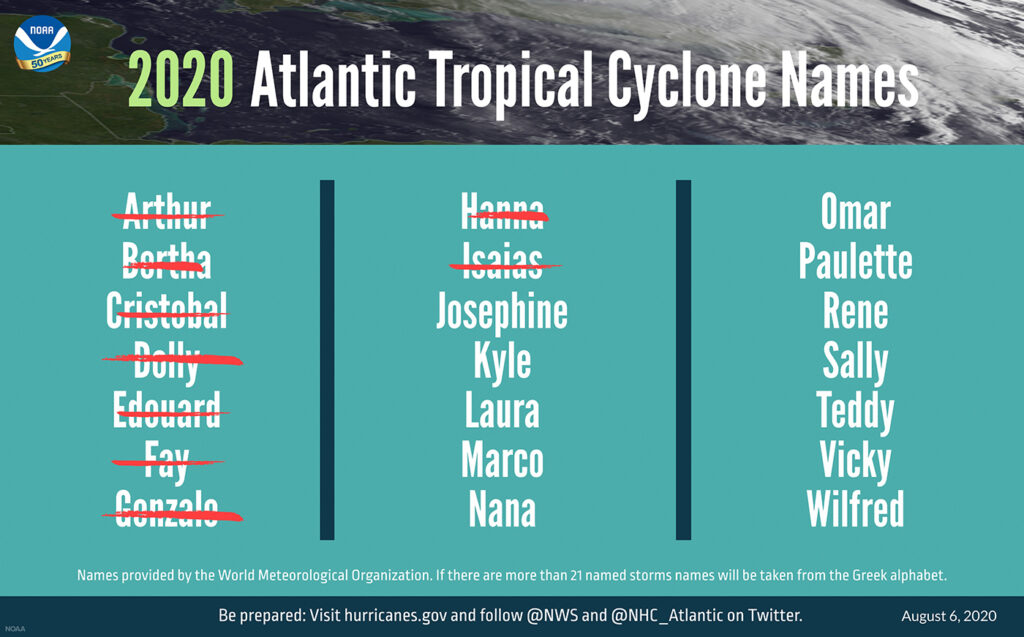
The 2020 Atlantic tropical cyclone names selected by the World Meteorological Organization. NOAA
The 2020 Atlantic hurricane season has been off to a rapid pace with a record-setting nine named storms so far. It has the potential to be one of the busiest on record, NOAA said.
Historically, only two named storms form on average by early August, and the ninth named storm typically forms on October 4. An average season produces 12 named storms, including six hurricanes, of which three become major hurricanes (Category 3, 4, or 5).
“Weather and climate models are all indicating an even higher likelihood of an extremely active season,” said NOAA’s chief hurricane seasonal forecaster Gerry Bell.
Driving the forecast is a series of factors that point to an unusually active season. These include widespread above average sea surface temperatures in the tropical Atlantic Ocean, particularly in the so-called “main development region” between West Africa and the Leeward Islands, where many storms form. In addition, there are above average temperatures in the Caribbean Sea, and sea surface temperatures are also running well above average off the East Coast and in the Gulf of Mexico. The warm waters are due in part to long-term, human-caused climate change, as well as natural climate cycles.
Also drawing forecasters’ attention is a developing La Niña event in the tropical Pacific Ocean. Such episodes, which feature cooler than average water temperatures in the central to eastern tropical Pacific, tend to slacken upper level winds over the tropical Atlantic. This removes an impediment to tropical storms and hurricanes, since they are highly vulnerable to wind shear, which occurs when winds blow at different speeds and/or directions with height. Too much shear can tear a nascent storm apart.
Another major factor this year is a cycle known as the Atlantic Multidecadal Oscillation. It sets the Atlantic up for above average odds of years’ worth of particularly active storm activity. We are in such an active phase right now, though that doesn’t mean that every season will set records. The current active phase of the AMO has lasted since 1995.
In addition, Bell said, an unusually active West African monsoon season is leading to more storm-forming opportunities, as thunderstorms emerge off the west coast of Africa, and have a chance to develop into a tropical storm or hurricane. Years that feature unusually dry conditions in central Africa tend to be less active.
The new outlook is unwelcome news for a country already reeling from the coronavirus pandemic, which complicates storm evacuation and shelter logistics.
During Hurricane Isaias, for example, many people were told to shelter in place or go to a hotel or stay with relatives to keep crowding down in shelters, due to social distancing requirements. The Federal Emergency Management Agency is having to deal with an unprecedented circumstance in which all 50 states have been declared disaster areas due to the virus, while also gearing up for responding to tropical storms and hurricanes, which is among the toughest challenge the agency faces.
The U.S. has already been hit by two landfalling hurricanes, both of which were Category 1 storms.
To determine whether a season is “extremely active,” NOAA uses a measure of the overall hurricane season activity, known as the Accumulated Cyclone Energy index, which incorporates both the intensity and duration of all named storms during the season. “This year, we expect more, stronger, and longer-lived storms than average, and our predicted ACE range extends well above NOAA’s threshold for an extremely active season,” Bell said in a press release.
Send questions/comments to the editors.

Success. Please wait for the page to reload. If the page does not reload within 5 seconds, please refresh the page.
Enter your email and password to access comments.
Hi, to comment on stories you must . This profile is in addition to your subscription and website login.
Already have a commenting profile? .
Invalid username/password.
Please check your email to confirm and complete your registration.
Only subscribers are eligible to post comments. Please subscribe or login first for digital access. Here’s why.
Use the form below to reset your password. When you've submitted your account email, we will send an email with a reset code.