

WGME graphic
A high-impact storm will bring rain, wind, and even some snow to Maine and New Hampshire during Saturday and the first half of Sunday.
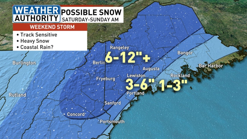
A Winter Storm Watch has been issued for much of inland Maine and New Hampshire. The potential exists for heavy snowfall and significant accumulations.
The biggest uncertainty with this storm remains its track. Small shifts in the track result in dramatically different scenarios for our area.
Some computer models take the center of the storm right over eastern New England. This scenario would result it:
• Temperatures in the 40s/50s with widespread rain
• Strong wind gusts, especially along the coast
• Heavy, accumulating snowfall for the mountains
This would be great news for ski country, as this setup would bring several inches of natural snow to the resorts. Other computer models take the center of the storm to the east of New England. In this case, we would expect:
• Colder air and more widespread snow, even at the coast
• Gusty but likely non-damaging winds
At this point, the greatest chance for a plowable and possibly significant snowfall is across far inland Maine and northern New Hampshire. A few inches of snow are possible away from the immediate coast. More rain than snow at the coast means meager snowfall at best.
As the storm pulls away on Sunday, colder air will push into northern New England. A few snow showers will linger into the morning, before a slow clearing takes place during the afternoon.
Send questions/comments to the editors.

Success. Please wait for the page to reload. If the page does not reload within 5 seconds, please refresh the page.
Enter your email and password to access comments.
Hi, to comment on stories you must . This profile is in addition to your subscription and website login.
Already have a commenting profile? .
Invalid username/password.
Please check your email to confirm and complete your registration.
Only subscribers are eligible to post comments. Please subscribe or login first for digital access. Here’s why.
Use the form below to reset your password. When you've submitted your account email, we will send an email with a reset code.