


It’s official: 2020 was the warmest year on record in Portland.
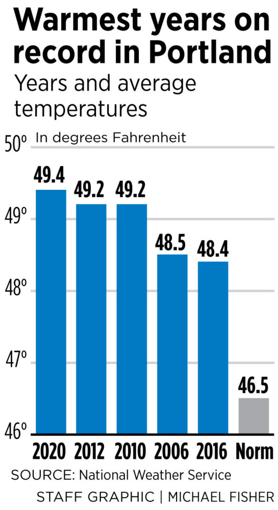
The National Weather Service says 2020 was Portland’s warmest year since record keeping began in 1940. With an average temperature of 49.4 degrees, Portland topped the previous record of 49.2 degrees, which was the average temperature in both 2010 and 2012. The normal average temperature for Portland is 46.5 degrees.
The new record isn’t much of a surprise, after a year in which Portland recorded its hottest summer, its hottest July and a slew of other daily temperature records.
Maine kicked off 2020 with an unusually warm Jan. 11. On that day, the temperature in Portland was 63, a high for that day that broke the previous mark of 54 degrees in 2017.
During 2020, Portland had a record number of days with the warmest low temperatures. There were nine days when the temperature did not dip below 70 degrees at night, which broke records of eight days in 2018 and five days back in 2001 and 1988. There were 36 days last year when the temperature stayed above 65 degrees. The previous high was in 2018, when there were 28 days with a daily low temperature above 65 degrees.
“We really blew that one out of the water, so to speak,” said William Watson, a meteorologist at the National Weather Service office in Gray.
Besides July, there were seven other months – January, February, March, June, August, September and November – that are now in the top 10 warmest for those individual months in Portland, according to the weather service.
The average temperature for the three-month period from June to August in Portland was 70.5 degrees – more than 1.5 degrees warmer than the previous record set in 2018 and 3.6 degrees hotter than the “normal” summer temperature in the city. The daily average highs and lows are used to compute those figures.
July also went down in the record books as the hottest month ever in Portland, with an average temperature of 73.7 degrees. That was nearly 5 degrees hotter than normal for Maine.
Last year was also the driest on record since 2004, with 41.48 inches of precipitation. That’s about 6 inches below normal, Watson said. That lack of rain led to extreme drought conditions in parts of Maine, including some of York County.
During 2020, Portland got a total of 53.3 inches of snow, more than 8 inches below normal.
“It was the first calendar year with below normal snowfall since 2010,” Watson said.
The last spring freeze of the year in Portland was on April 23, one of the earliest on record. The earliest last spring freeze on record was on April 14, 1983. Last year ties for ninth with 2018, 2011 and 1994, according to the weather service.
Send questions/comments to the editors.

Success. Please wait for the page to reload. If the page does not reload within 5 seconds, please refresh the page.
Enter your email and password to access comments.
Hi, to comment on stories you must . This profile is in addition to your subscription and website login.
Already have a commenting profile? .
Invalid username/password.
Please check your email to confirm and complete your registration.
Only subscribers are eligible to post comments. Please subscribe or login first for digital access. Here’s why.
Use the form below to reset your password. When you've submitted your account email, we will send an email with a reset code.