

It’s been four days since Hurricane Ida lay siege to Louisiana and demolished parts of the Gulf Coast, the borderline Category 5 storm tying as the eighth most intense to ever hit the Lower 48 and the strongest on record in Louisiana. Now, the remnants of Ida are moving through the eastern U.S., expected to drop very heavy flooding rains and a few tornadoes that could bring a day of high-impact weather to the Interstate 95 corridor.
An extremely rare high risk for heavy rain and flash flooding has been declared for parts of the Northeast and mid-Atlantic, the most severe outlook category the National Weather Service can hoist ahead of an anticipated flood event. They’re calling for “widespread and potentially life-threatening flooding,” with totals of 3 to 8 inches likely in a broad swath hundreds of miles long.
Cities like New York and Hartford, Conn., are included in the outlook bull’s eye, with other places like Baltimore, Philadelphia and Providence, R.I., bracing for major disruptions to travel too. Flash flood watches stretch from the Blue Ridge in North Carolina to Maine.
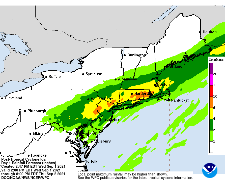
In some areas, 24-hour rainfall totals could represent 1-in-100 year events, or have just about a 1 percent chance of happening in any given year.
“Signals remain strong for potentially deadly and damaging flash flooding,” the Weather Service wrote Wednesday.
Twenty million people are in the high risk zone for flooding with an additional 32 million in the surrounding moderate risk area, according to Alex Lamers, a meteorologist at the Weather Service.
The Big Apple concluded August with more than ten inches of rainfall, about a half foot more than typically expected. Soils are saturated and can’t handle much additional rainfall, exacerbating the risk of additional serious flash flooding. Many areas just to the south of the Tri-State are still running well ahead of normal following the passage of Henri just two weeks ago, which helped drop up to nine inches of rain in Monmouth and Middlesex Counties in New Jersey.
“With recent wet antecedent conditions, excessive rain will easily become runoff and lead to the potential for flash flooding in poor drainage and low lying areas,” wrote the Weather Service in New York.
High-resolution model simulations are projecting a 75 percent chance of at least 8 inches falling in south central Pennsylvania in the vicinity of Harrisburg and just to the northeast, which will probably be among the hardest hit areas.
That all comes beneath the core of the expected track of Ida’s waterlogged remnants; a surge of warm, moist air to the east could brew severe weather and potential tornadoes. At least one tornado already struck Blacksburg in southwest Virginia on Tuesday, prompting tornado sirens to blare on the campus of Virginia Tech.
Widespread one-day rain totals of several inches were reported in western North Carolina, the Appalachian Foothills of Georgia and the Cumberland Plateau of eastern Tennessee on Tuesday. Areas just northwest of Washington, D.C., in Montgomery County, Md., and Fairfax County, Va., also received up to 3 inches from overnight thunderstorms associated with Ida.
Ida’s remnants have been acquiring mid-latitude characteristics, meaning the storm is no longer a perfectly-blended swirl of tropical air and uniform spin. Instead, an insurgence of cool, dry air on the backside of Ida has helped develop fronts. It’s along a stalled cold front draped along the Appalachians that Ida will unleash most of its moisture.
Rainfall rates of more than an inch per hour could accompany downpours that will increase in both areal coverage and intensity throughout the day. Some places may see totals approaching two inches in an hour or less, bolstering the risk of drainage systems becoming overwhelmed – especially in major urban areas.
Flash flooding is likely and could be widespread, and may coincide with the first half of the overnight, making it extremely difficult to see or recognize areas of inundation. It’s worth noting that “high risk” flooding days only occur about 4 percent of the time, but account for 40 percent of all U.S. flood-related fatalities.
Boston proper will probably end up with 3 or 4 inches; flash flooding is likely there, as well as in the other major metropolitan areas of southern New England and the Tri-State.
It’s not out of the question that a few communities somewhere in the Northeast see double-digit rain totals, the result of extremely high rainfall rates contained within storms that may train over the same area.
The rainfall will finally push offshore of southeastern New England by about 9 a.m. Thursday. Much cooler, drier and more refreshing air will arrive in the wake of Ida’s tropical remnants.
The Washington Post’s Jason Samenow contributed to this report.
Send questions/comments to the editors.

Success. Please wait for the page to reload. If the page does not reload within 5 seconds, please refresh the page.
Enter your email and password to access comments.
Hi, to comment on stories you must . This profile is in addition to your subscription and website login.
Already have a commenting profile? .
Invalid username/password.
Please check your email to confirm and complete your registration.
Only subscribers are eligible to post comments. Please subscribe or login first for digital access. Here’s why.
Use the form below to reset your password. When you've submitted your account email, we will send an email with a reset code.