


UPDATED 11:20 AM:
Moderate to heavy snow at our office in Gray, ME now. What are you experiencing? #MEwx #NHwx pic.twitter.com/75yGTF8CCO
— NWS Gray (@NWSGray) February 4, 2022
UPDATED 10:01 AM: TURNPIKE CRASHES
The driver lost control of a tractor trailer heading south Friday morning on the Maine Turnpike in York. The truck first struck the center guardrail causing the rear of the truck to swing and strike the shoulder guardrail. The truck then came to rest in the center of the road blocking all three lanes. The York Fire Department responded to the crash for loss of motor oil on the road. The driver was not injured. No summons was issued. Maine State Department of Public Safety
The Maine Department of Public safety has reported more than 10 crashes on the Maine Turnpike since 6:00 a.m. Troopers are responding to one crash after another on the Turnpike because people are driving too fast for road conditions, according to Public Information Officer Shannon Moss.
No injuries have been reported.
UPDATED 7:20 AM: A winter storm is dropping a hazardous mix of ice, sleet and snow on Maine as officials warn people to stay off the roads Friday morning.
Temperatures across Maine dropped overnight and most area are expected to receive at least several inches of sleet and snow before the storm winds down later Friday.
The National Weather Service warned of a messy morning commute as people wake up to snow covered roads. In parts of southern Maine and New Hampshire, sleet and snow are falling Friday morning on top of large puddles and wet roads from Thursday’s rain.
Friday’s storm is the second to slam the state in less than a week. A nor’easter packing blizzard conditions dumped up to 20 inches of snow in some places, including Brunswick, last Saturday.
The most significant threat on Friday will be a dense accumulation of ice and sleet – 1 to 2 inches in the Portland area, according to the weather service. By the time the storm ends in Portland on Friday afternoon, the ice and sleet could be covered with about 6 inches of snow.
“There’s a fine line right now between snow and sleet. It currently runs from Fryeburg to Lewiston to just south of Augusta,” Mike Ekster, senior meteorolgist at the weather service office in Gray, said at 7 a.m.
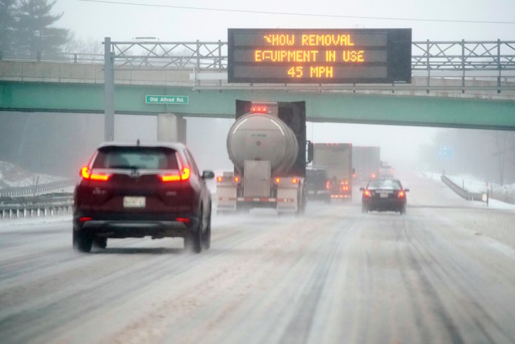
Cars and trucks travel northbound along the Maine Turnpike in Arundel through a messy wintry mix on Friday morning. The speed limit on the turnpike is reduced to 45 mph. Staff photo by Gregory Rec
South of that line, there is a mix of snow, sleet and freezing rain that is expected to linger until midday before gradually switching over to snow as temperatures fall.
“The sleet should pile up quite a bit,” Ekster said.
North of that line, it is snowing heavily at times. Fryeburg, Rumford, Rangeley, Jackman and Skowhegan could get 12 to 18 inches before the storm ends, and northern Cumberland County, Auburn and Augusta could get 6 to 12 inches.
By Friday night, temperatures will bottom out around 10 degrees, Ekster said. He advises people to tackle clean up of driveways and walkways today, especially if they are in an area with mixed precipitation.
“You’re going to want to clear your driveway because it will freeze solid like a rock tonight,” he said.
A winter storm warning is in effect for most of the state until 7 p.m. Additionally, a small craft advisory in effect until 7 a.m. Saturday warns of hazardous conditions created by wind gusts up to 30 knots and seas of 5 to 8 feet.
Dozens of school districts in southern and central Maine announced traditional snow days or remote learning days Friday. Many child care centers, libraries and businesses also are closed. In Portland, city hall and other city buildings will be closed to the public Friday because of the weather.
All state offices are closed Friday. Gov. Janet Mills issued a statement Thursday asking people to stay off the roads.
“With driving expected to be difficult during this winter storm, I strongly urge all Maine people to stay off the roads if possible to help avoid accidents and to allow our state and municipal road crews to work safely,” Mills said.
Speed limits on the Maine Turnpike and I-295 are reduced because of slippery conditions.
Most flights in and out of the Portland International Jetport Thursday night and Friday morning are canceled.
“Their biggest concern is the ice and icy conditions. But, it’s not just Portland that’s being affected. It’s happening up and down the East Coast,” jetport spokesman Zachary Sundquist said Thursday.
Nationally, more than 6,200 flights had been canceled and hundreds more were delayed by Thursday evening, according to the flight-tracking website FlightAware.
High wind gusts, which can lead to power outages, should not be a problem on Friday, but Central Maine Power Co. said its crews are prepared. The company’s 200 line workers will be assisted by 114 contractor crews from Maine and outside the state, along with 97 tree workers.
CMP reported about 1,200 outages at 6:46 a.m., with the majority in Oxford Country. Versant Power, which serves northern and eastern Maine, reported 91 outage early Friday.
This story will be updated.
Send questions/comments to the editors.

Success. Please wait for the page to reload. If the page does not reload within 5 seconds, please refresh the page.
Enter your email and password to access comments.
Hi, to comment on stories you must . This profile is in addition to your subscription and website login.
Already have a commenting profile? .
Invalid username/password.
Please check your email to confirm and complete your registration.
Only subscribers are eligible to post comments. Please subscribe or login first for digital access. Here’s why.
Use the form below to reset your password. When you've submitted your account email, we will send an email with a reset code.