


Maine’s Land Use Planning Commission on Wednesday approved a new zoning plan that Moosehead Lake stakeholders and members of the state’s environmental community say will protect the outdoor recreation region from sprawling development plans like the one proposed in 2009 by the Plum Creek Timber Company.
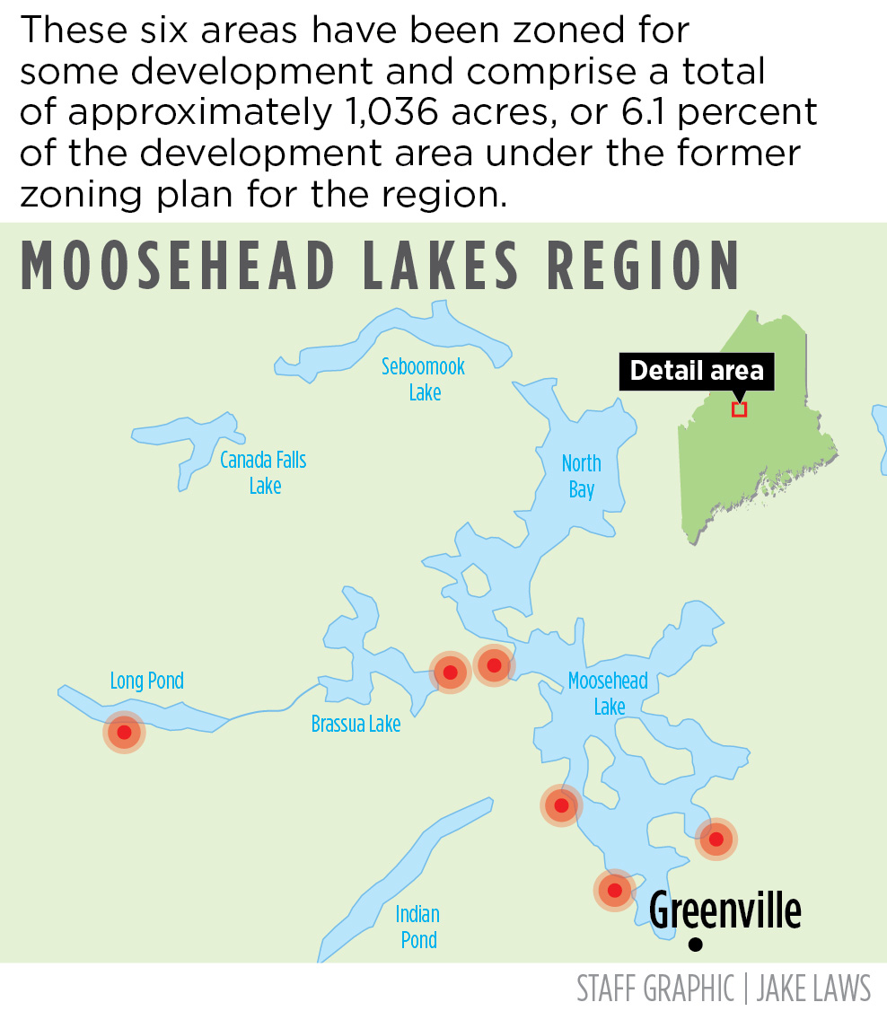
Unlike the controversial Plum Creek proposal, which envisioned the construction of nearly 1,000 homes and two resorts near Maine’s largest lake, the “Moosehead Regional Planning Package” will create six development zones comprising a total of 1,036 acres or 6.1% of the 16,910 acres originally designated for development by Plum Creek.
Plum Creek’s development plan sparked one of the largest and costliest regulatory reviews in Maine history. After years of fierce debate and hundreds of hours of hearings, the Land Use Planning Commission, then called the Land Use Regulation Commission, agreed in September 2009 to rezone nearly 400,000 acres in the Moosehead Lake region.
The vast majority of that acreage was permanently protected from development – while still allowing sustainable forestry – through easements or sales to conservation groups in what was then the second-largest conservation deal in U.S. history. In return, Plum Creek was granted the right to develop 975 house lots and two large resorts near Moosehead Lake. In 2016 Plum Creek merged with Weyerhaeuser, the Seattle-based timberland company.
Late 2019, Weyerhaeuser asked the state to terminate the massive rezoning plan for the Moosehead Lake region. Weyerhaeuser told the Land Use Planning Commission that the company also intended to end development and subdivision zoning rights for the house lots and two resorts near Moosehead Lake.
“Unfortunately, the impact of the 2008-09 recession forever changed the United States development landscape,” Weyerhaeuser senior asset manager Luke Muzzy wrote to the commission in 2020. “As a result, and despite our best efforts, the development components under the Moosehead Lake Region Concept Plan have not been implemented and no development has occurred.”
In July 2020, the state terminated the Moosehead Lake Region Concept Plan.
As a result, Weyerhaeuser and the commission agreed to provide an opportunity for residents and stakeholders to participate in planning future land uses in the Moosehead Lakes region. The two-year process led to the plan approved Wednesday by the commission, which limits the scale and intensity of development that can occur in areas identified by the community as important to the natural and scenic character of the region.
STRIKING A BALANCE
The Natural Resources Council of Maine believes the zoning plan strikes a good balance between economic development opportunities and conservation of the region’s natural resources and lands.
The new zoning plan funnels residential and commercial development into six zones, which are located near the region’s larger communities, including Greenville and Rockwood. The plan also protects the remote character of several lakes in the region by removing areas around Indian Pond, Long Pond and portions of Brassua Lake from the development zones.
In a telephone interview Wednesday night, Melanie Sturm, the NRCM’s forests and wildlife director, said she was pleased with the level of community engagement the Land Use Planning Commission conducted to come up with the zoning plan.
“I think this is a good example of what can happen when the LUPC works with a community to develop a plan that is acceptable to everyone. You end up getting a plan that is responsive to the community’s needs and sets the region up for success,” Sturm said.
Sturm said the new zoning plan will concentrate development in and around the more populated areas of Moosehead Lake, including Greenville, Rockwood and Beaver Cove. Sturm said the approach will prevent the sprawl that Plum Creek’s project would have generated and will protect the natural resources and scenic areas that both locals and visitors treasure.
“This plan will ensure that going forward the Moosehead Lake region will continue to be a natural resources destination,” Sturm said.
A spokesman for Weyerhaeuser reacted to the commission’s decision late Wednesday night.
“This rezoning is a positive step for the Moosehead region,” Christopher Fife said in an email. “Through its comprehensive planning process, the LUPC engaged the community to develop a plan that provides predictability for the Moosehead region.”
Fife said Weyerhaeuser will continue to practice sustainable forest management while providing an opportunity for growth that complements the existing conservation and recreational agreements.
Public benefits from the original master plan include 363,000 acres of Weyerhaeuser land that are permanently protected under a conservation easement, permanent hiking trail easements on 121 acres, a permanent easement for 81 miles of snowmobile trails, and a donation of 50 acres for recreation infrastructure. The hiking trail easements were made possible by a $1 million donation to create the trails, Fife said.
Under the new zoning plan, the areas available for development have been scaled down from 16,910 acres to 1,036 acres, concentrated in the six development zones.
Those zones, according to commission records include: Beaver Cove, general development encompassing 7.20 acres; Big Moose Township, general development, 496 acres; Big Moose Township, residential, 240 acres; Long Pond Township, residential, 15 acres; Taunton and Raynham Academy Grant, residential, 160 acres; and Taunton and Raynham Academy Grant, 118 acres.
An additional 73,207 acres near Indian Pond, Brassua Lake and Long Pond have been removed from the primary and secondary locations suited for development. More than 359,000 acres will be conserved in the region as part of a Forest Society of Maine conservation easement.
NOT EVERYONE SATISFIED
Not everyone who lives and works in the Moosehead region was satisfied with the Land Use Planning Commission’s decision. Some felt more steps could have been taken to protect wildlife habitat, one of the region’s visitor draws. Moosehead Lake offers a variety of recreational options including hiking, hunting, boating, fishing, snowmobiling, cross-country skiing and ice fishing.
In a statement, the NRCM said that the commission chose not to designate any new protection zones for critical fish and wildlife habitat, including protections for the federally endangered Canada lynx and rare species such as the rusty blackbird.
Environmental groups had asked for those protections to be put in place to provide a buffer against development and commercial activity.
Registered Maine Guide Wendy Weiger, who lives off the grid in a cabin on First Roach Pond in Frenchtown, said she wished the commission had created new protection zoning for the Lily Bay peninsula and the south shore of Indian Pond.
“These places are integral components of the Moosehead brand and are essential to sustaining the region’s nature tourism economy,” she said.
“We’re disappointed that no changes were made to specifically protect the species that inhabit the region, especially because fish and wildlife face increasing stress from climate change, pollution, development and invasive species,” Sturm added.
The Land Use Planning Commission, which has 10 members, serves as the planning and zoning authority for Maine’s unorganized and deorganized areas, including townships and plantations. These areas either have no local government or have chosen not to administer land use controls at the local level.
Send questions/comments to the editors.

Success. Please wait for the page to reload. If the page does not reload within 5 seconds, please refresh the page.
Enter your email and password to access comments.
Hi, to comment on stories you must . This profile is in addition to your subscription and website login.
Already have a commenting profile? .
Invalid username/password.
Please check your email to confirm and complete your registration.
Only subscribers are eligible to post comments. Please subscribe or login first for digital access. Here’s why.
Use the form below to reset your password. When you've submitted your account email, we will send an email with a reset code.