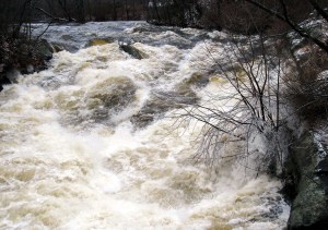
MEXICO — Rain-swollen tributaries across western Maine, like the Webb River, continued to rage into the Androscoggin River on Tuesday as a cold front began pushing through.
Monday’s temperatures in the high 40s to low 50s fell Tuesday toward more seasonable highs of mid to low 20s by 2 p.m. in Rumford, keeping crews busy treating wet roads that began icing over.
Flooding continued to be minimal to nonexistent, emergency management agency officials in Androscoggin, Franklin and Oxford counties said early Tuesday afternoon.
Meteorologist Michael Cempa of the National Weather Service in Gray said Tuesday morning that 3 to 4 inches of rain fell across the western mountain region Sunday night through Monday morning.
That was followed by another half inch on Monday, along with unseasonably warm temperatures that continued Tuesday in northern Maine.
“When we were still in the upper 20s here, it was 46 in Caribou,” Cempa said.
Most road closures due to flooding were in Androscoggin County in Auburn and Durham, where the Androscoggin River had risen about 2 feet above Auburn’s 13-foot flood stage.
“We’re high and dry here, but there are the usual (closures) when we get to about 14 feet, which is really no major problem for us,” Joanne G. Potvin, Androscoggin EMA director, said.
“The National Weather Service says we’re going to go to about 15.3 feet sometime at midday today, and the water will start to go up, but really, I expect no significant problems.”
Low areas on Route 136 in Durham remained closed on Tuesday due to flooding, along with Cedar Pond Road in Durham, which is also submerged.
“And of course, the North River Road from Center Street on up, right behind Higgins Sports Center,” Potvin said of an Auburn road. “That floods in the middle of summer when we get one inch of rain, because the road is actually lower than the river is.”
Potvin said she spoke with other area EMA directors and officials on Tuesday morning for an update.
“We have no significant problems, and everybody is pretty much high and dry, so right now we’re at 14 1/2 feet,” she said. “And it looks like it’s leveled off at 14 1/2 feet, so we’ll wait and see what happens a little bit later, but it should be receding later tonight and pretty much back to normal by the weekend.”
An EMA official in Paris said there wasn’t any flooding in Oxford County, while another in Franklin County said the Sandy River, which surged over its banks on Monday morning, is back in its channel.
She said she believed all roads flooded on Monday were above water on Tuesday, although Director Tim Hardy was out checking the low-lying George Thomas Road in Chesterville.
Meteorologist Cempa said December’s weather pattern this month in Maine “is a little bit different than we’re used to.”
“The jet stream is a little bit more amplified,” he said. “It goes a little bit more north and south than we’re used to seeing this time of year, and so we’ve sort of been stuck in that pattern where we go from cold to warm.”
Other than some light snow Tuesday night into Wednesday, he said the only potential for something more significant could happen this coming Sunday into Monday from a developing ocean storm that could evolve into a nor’easter.
It is expected to develop off the Mid-Atlantic Coast late Sunday, and then move southeast of Cape Cod on Monday.
“It could stay far enough offshore and not even do much for us, but I tend to think that if this one is going to do something for us, it’s probably a better chance it would be snow than rain,” Cempa said.
Which is good news for ski areas, especially the smaller ones that don’t have the equipment and money to circumvent Mother Nature’s shortcomings in December.
As of Monday, Cempa said the Portland Jetport had received about half an inch of snow for the month. Normally, Portland would have 7.6 inches by Monday, he said.

Supporting Sponsor for the Advertiser Democrat
Keeping communities informed by supporting local news. norwaysavings.bank

Supporting Sponsor for Franklin Journal, Livermore Falls Advertiser, Rangeley Highlander and Rumford Falls Times.
Keeping communities informed by supporting local news. franklinsavings.bank


Comments are no longer available on this story