

PORTLAND, Maine — Weather forecasters tracking Hurricane Irene expect it could deliver as much as five inches of rain and 40 mile-per-hour winds even if it misses Maine.
Meteorologist Eric Leister of the State College, Penn.,-based Accuweather.com said it’s a good bet the storm will, however, hit the state directly.
Leister said he expects Irene to spin its way to the Pine Tree State by late Sunday night or early Monday morning, with her entourage of smaller rainstorms to begin as early as Sunday afternoon.
“It looks like you’re pretty much in one of the favored track areas,” Leister told the Bangor Daily News. “The good news is, it’ll be at a weakened strength by the time it gets there, maybe as a tropical storm. Of course, maybe it could hang onto Category 1 status.”
Hurricane Irene reached Category 3 status today while northeast of the Bahamas, and forecasters are expecting winds blowing 125 mph or more by the time it passes Florida and the Carolinas today and tomorrow.
From there, Leister said, Irene very well might cruise right up the Eastern Seaboard to Vacationland.
“It doesn’t look like it’ll be veering east like a lot of hurricanes do,” he said. “It looks like it’s going to come right through the state.”
Even if it does drift off shore somewhat, Leister said, Mainers should brace for heavy rains and high winds.
“I could see several inches of rain — maybe as much as five inches of rain,” he said. “That’s why I think the rainfall is going to be the story here.”
Dennis Feltgen, spokesman for the U.S. National Hurricane Center in Miami, Fla., said it’s too early to tell what trajectory Irene will take as she whips north, but said because of the immense size of the storm, New Englanders should “make sure you have your hurricane supplies.”
Feltgen said the center forecasts the path of hurricanes five days out, and feels most confident about the next 24 to 48 hours. Irene’s arrival in Maine isn’t due until the tail end of that forecast, he said.
“Even if the core of the storm stays off shore, it could have a serious impact in terms of wind and rain all the way up to New England,” he said. “It’s a rather large storm.”
Feltgen said tropical storm force winds are being recorded 200 miles from the center of the storm — a good 50 to 75 miles farther out than an average storm. He warned that the heavy rains could saturate the ground and create flooding hazards, and the winds could down tree limbs and wreak havoc on utility lines all the way to Maine.
He urged Mainers to follow the updated tracks of the storm vigilantly through the center’s website, hurricanes.gov.
Reprinted with permission from the Bangor Daily News.
-

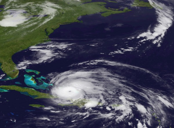
- An image released by the NOAA made from the GEOS East satellite shows Hurricane Irene on Aug. 24, 2011 as it moves northwest from the Dominican Republic. Federal officials have warned Irene could cause flooding, power outages or worse all along the East Coast as far north as Maine, even if it stays offshore.
Send questions/comments to the editors.

Success. Please wait for the page to reload. If the page does not reload within 5 seconds, please refresh the page.
Enter your email and password to access comments.
Hi, to comment on stories you must . This profile is in addition to your subscription and website login.
Already have a commenting profile? .
Invalid username/password.
Please check your email to confirm and complete your registration.
Only subscribers are eligible to post comments. Please subscribe or login first for digital access. Here’s why.
Use the form below to reset your password. When you've submitted your account email, we will send an email with a reset code.