
“I just came home and was sitting on the couch with my cat when I felt my whole house shaking,” said Lisa Ackley of Bridgton. “I thought my furnace must be exploding.”
Ackley wasn’t alone. Thousands of people across the region called emergency dispatch centers, television stations, newspapers — even the National Weather Service — in search of explanations. Still more called relatives from neighboring towns and states in hopes of figuring out just how far the tremor rippled.
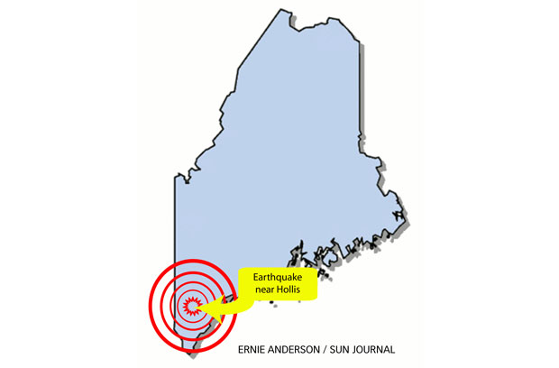
The U.S. Geological Survey website reported the 7:12 p.m. earthquake occurred about 3 miles west of Hollis Center and 13 miles northwest of Saco and Biddeford. The agency reported Tuesday night the earthquake had a depth of 3 miles and was felt as far away as New York and New Jersey.
“The deeper they are, the less they’re felt at the surface,” said Mike Kistner, a meteorologist with the National Weather Service. “The more shallow they are, the more they’re felt at the surface.”
Kistner said given the earthquake’s depth of 3 miles, it made sense that the tremor was felt all over New England. He said earthquakes in the Northeast are rare.
According to the U.S. Geological Survey, a magnitude 4.0-magnitude earthquake occurring in the eastern United States is typically felt as far as 60 miles from the epicenter. Such events do not likely cause damage near the source. The agency reported Tuesday’s earthquake as moderate with strong shaking, but minimal injuries and damage.
Kistner said the National Weather Service took one report of a cracked floor in Brunswick. WGME-13 reported a house fire in Saco believed to be a direct result of the earthquake and major structural damage to a Biddeford building.
Many people initially mistook the shaking for a malfunctioning furnace. Others, like Rocky Blier of Auburn, thought it might be a train or a tractor-trailer.
“I was sitting there watching TV and the whole house was shaking and the lights were shaking,” said Blier, who lives on Hotel Road. “I don’t ever recall having one bigger and I’ve been in this area 70 years off and on.”
The U.S. Geological Survey reported moderately damaging earthquakes strike somewhere in the region every few decades, and smaller earthquakes are felt roughly twice a year. The largest known New England earthquake was a 6.5-magnitude quake that occurred in 1638 in Vermont or New Hampshire. The most recent New England earthquake to cause moderate damage occurred more than 60 years ago in central New Hampshire. The 5.6-magnitude tremor occurred in 1940.
The strongest earthquake recorded in Maine was in 1904 in the Eastport area, near the state’s eastern border with Canada, according to the Weston Observatory at Boston College. With a magnitude estimated at 5.7 to 5.9, it damaged chimneys and brick walls and could be felt in Massachusetts and New Hampshire.
East Coast quakes are rarely strong enough to be felt over a wide area. A quake of magnitude 5.8 on Aug. 23, 2011, was centered in Virginia and felt all along the coast, including in New York City and Boston. Experts say the region’s geology can make the effects felt in an area up to 10 times larger than quakes of similar size on the West Coast.
The Associated Press contributed to this report.
Comments are no longer available on this story