

ROCKLAND — Proposed new maps that detail flood-prone areas may sharply increase insurance rates and hamper the ability to develop some key areas of the city’s waterfront.
“Rockland is taking a beating,” said consulting engineer Robert Gerber. “Rockland is being affected more severely than most communities.”
The draft flood maps, developed on behalf of the Federal Emergency Management Agency, were distributed to communities in Knox and Waldo counties in July. “Preliminary” maps — which communities can use to officially challenge the findings — are not expected be given out to the towns and cities until the end of January or early February, said Kerry Bogdan, a senior engineer for FEMA in its Boston regional office.
The maps, which are intended to show areas most at risk of flooding, are scheduled to be finalized by the spring of 2015. With the finalized maps will come regulations on how owners can build on their property, as well as whether they need to purchase increasingly costly flood insurance.
The proposed maps for Rockland shift the boundaries considered a flood-prone area about 100 feet inland from the current maps developed in 1989.
The FEMA maps project that there is a 1 percent chance in any given year that parts of Rockland would be under several feet of ocean water. For example, FEMA predicts the possibility of the water level rising to 14 feet above the mean tide in Lermond’s Cove, which is situated between FMC and the city’s wastewater treatment plant. Mean tide refers to the tide level halfway between the average high and low tides. On the east side of FMC, FEMA predicts the possibility of flooding 19 feet above the mean tide.
Stretches of the city’s waterfront — from the public landing north to where Prock Marine operates — will see the most change, based on the draft maps. The maps indicate that the ocean will rise to 4 feet higher in a flood than is projected in the current maps and that these areas will be subject to waves of 3 feet or more in addition to the higher ocean level.
Properties added to the flood zone include the city’s public landing, the parking lot in the rear of Main Street Thorndike office and residential complex, and two downtown Main Street buildings closest to the Maine State Ferry Terminal.
The base flood level is crucial because that determines how a property in that area can be developed.
In a flood zone, the lowest level of a building must be at least one foot higher than the base flood level. The same holds true if existing buildings undergo substantial renovations or additions. In the flood zones subject to wave action — which the new maps conclude are much of the waterfront — buildings must be built on posts or have blow-out panels as part of the construction to allow flood waters to pass through without destroying the structure. There currently are no buildings on land which have been constructed this way in Rockland. Two restaurants are located on piers.
And the extension of flood zones to already developed areas means that these property owners will need to purchase flood insurance if they have a mortgage that is backed by the federal government. Flood insurance for properties even partially in a flood zone could see their premiums increase tenfold, according to Rockland Code Enforcement Officer John Root.
Bogdan said that the increase in flood insurance costs are due to changes made in the legislation approved by Congress last year to help fund the National Flood Insurance Program. The flood insurance program website points out that rates are increasing sharply because the government is phasing out subsidies to properties in flood-prone areas. One example offered by the insurance program states that a property more than 1 foot below the base flood level could have its insurance premium for $200,000 of coverage jump from $2,235 to $25,000 annually.
City officials say they are frustrated by FEMA’s lack of candor on how the maps were developed. FEMA will not release information to the communities on how the maps were developed until the release of the preliminary maps, and then communities and property owners have only 90 days to file appeals. Even then, documents that FEMA classifies as working papers are considered proprietary and are not released, said Rockland City Manager James Smith.
Smith said that the areas in Rockland which have been added to the flood zones have never flooded. While FEMA would make it more difficult to build on the waterfront in Rockland, the agency is helping areas in New Orleans and New Jersey rebuild where there is regular flooding.
“This defies reason and common sense,” Smith said.
Root said that one question he has asked that has not been answered is whether the Rockland Breakwater, which reduces wave action, was factored into FEMA’s determination of wave height on the waterfront.
Gerber has been hired by 13 waterfront communities in York, Cumberland, Knox and Waldo counties to review the maps and assist the municipalities in responding to the proposed new flood lines with an eye to possibly getting them adjusted. Rockland, Camden and Isle au Haut hired Geber early in 2012.
Root said the city decided to hire Gerber because it wanted to be kept abreast of the issue, knowing the significant impact that changes to the flood zones could have on the community.
“He is acting as our eyes and ears,” the code officer said. Gerber also will help the city determine if there are anomalies in the new maps so that the city could challenge them and get them changed before they are declared final.
Rockland has already notified the largest waterfront property owners — FMC, which manufactures carrageenin at its plant off Tillson Avenue, as well as the O’Hara Corporation, which operates a marina, office buildings and other marine-related businesses.
FMC Plant Manager Jeff LaBrozzi said that the company is reviewing the information and discussing internally how to respond. FMC is self insured, so the issue of flood insurance will not adversely affect the plant, he said.
But what would be affected is any new construction, LaBrozzi said.
“From what it appears, it will be way more expensive to build,” he said.
Once the preliminary maps are provided to the city, Smith said that all property owners affected by the changes will be notified. The city manager and code officer said FEMA advised them not to release the draft maps but wait to disseminate the documents once they are at the preliminary stage.
Bogdan said FEMA advised the city officials not to release the draft maps because they had not been checked for quality assurance. She added that she does not expect significant changes between the draft maps and preliminary ones, but there may be refinements.
The new maps do not take into account any projections of rising sea levels due to climate change, she said. Instead the maps take into account any sea level rise from when the last maps were created. They also use a different formula for determining the impact from waves. Instead of using the average wave height, the highest 2 percent of waves are used.
Rockland is potentially facing the greatest impact because of the amount of commercial development in low-lying areas on the ocean, but there are flood zone changes proposed for other midcoast communities.
Gerber said that there are some properties in the outer harbor of Camden that are seeing changes, but the inner harbor fares well.
Isle au Haut will experience little negative effects, the engineer said, pointing out that most of the homes and buildings are above the flood level.
Belfast Code Enforcement Officer Todd Rosenberg said the maps are very preliminary, and he understands that FEMA may be adjusting them based on new aerial photography. Belfast will wait for the updated maps before it undertakes a review, he said.
-

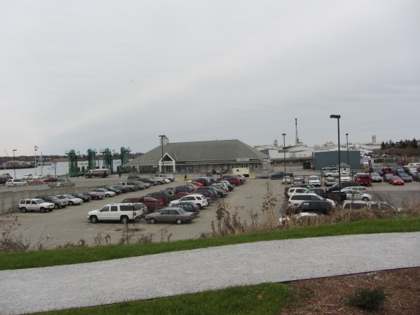
- The Maine State Ferry Terminal, Lermond’s Cove to the right and FMC (in the background) are all areas being added to the highest risk flood zone area based on draft maps from the Federal Emergency Management Agency.
Send questions/comments to the editors.

Success. Please wait for the page to reload. If the page does not reload within 5 seconds, please refresh the page.
Enter your email and password to access comments.
Hi, to comment on stories you must . This profile is in addition to your subscription and website login.
Already have a commenting profile? .
Invalid username/password.
Please check your email to confirm and complete your registration.
Only subscribers are eligible to post comments. Please subscribe or login first for digital access. Here’s why.
Use the form below to reset your password. When you've submitted your account email, we will send an email with a reset code.