

WGME map
Maine is facing a weekend of weather that could bring record high winter temperatures followed by an ice storm.
WGME map
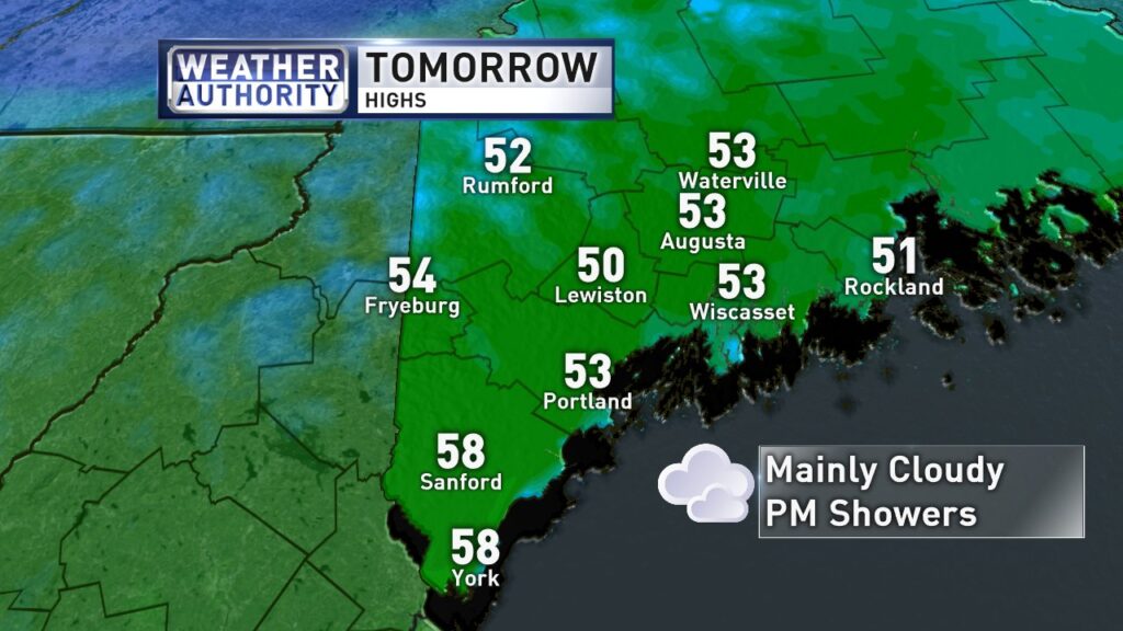
Saturday will be the warmest day of the stretch with temps surging into the low 50s, WGME reported.
Low clouds and fog look likely thanks to the warmer air moving over the cooler snowpack. A front will sag south Saturday night and a steadier rainfall is expected.
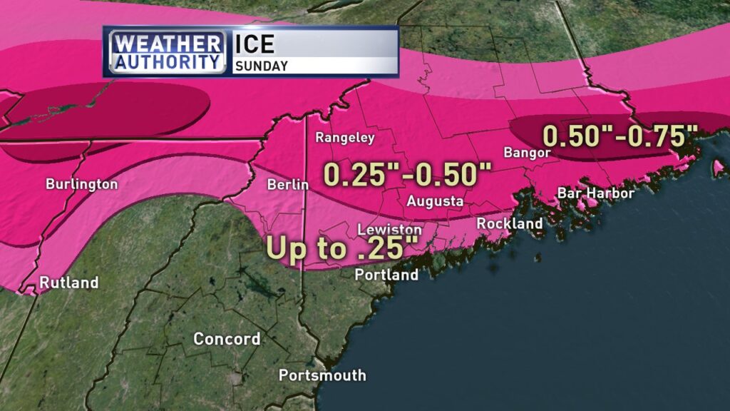
But temperatures are expected to plummet on Saturday night. Ground level temperatures will fall into the upper 20s and low 30s on Sunday while several thousand feet up they’ll be in the mid to upper 40s. That’s a recipe for freezing rain.
While rain will dominate southern and coastal Maine, sleet and freezing rain is likely inland.
Up to 0.25 to 0.50 inches of ice is expected. The most is expected in the mountains and foothills of Maine.
Power outages and tree damage are likely due to the ice.
Emergency responders and power companies were already getting ready Friday. Emera Maine said line crews will be at the ready for any outages that occur over the weekend. The utility reminded residents to avoid downed power lines, slow down for utility crews and take other safety precautions.
Travel could be very difficult.
Any leftover rain and freezing rain should end Sunday afternoon. Then northern Maine is expected to pick up several inches of snow Sunday night.

National Weather Service map
A Winter Storm Watch is in effect from 7 p.m. Saturday until 7 p.m. Sunday for all but southernmost Maine and coastal Maine.
Information from WGME and The Associated Press was used in this report.
Send questions/comments to the editors.

Success. Please wait for the page to reload. If the page does not reload within 5 seconds, please refresh the page.
Enter your email and password to access comments.
Hi, to comment on stories you must . This profile is in addition to your subscription and website login.
Already have a commenting profile? .
Invalid username/password.
Please check your email to confirm and complete your registration.
Only subscribers are eligible to post comments. Please subscribe or login first for digital access. Here’s why.
Use the form below to reset your password. When you've submitted your account email, we will send an email with a reset code.