

WGME map
Tuesday night’s little storm moved out early Wednesday morning, and now we’re on to the next weather maker.
Wednesday will be the nicest day in the extended forecast with highs in the low 40s and partly cloudy skies. However, snow moves in late Wednesday night.
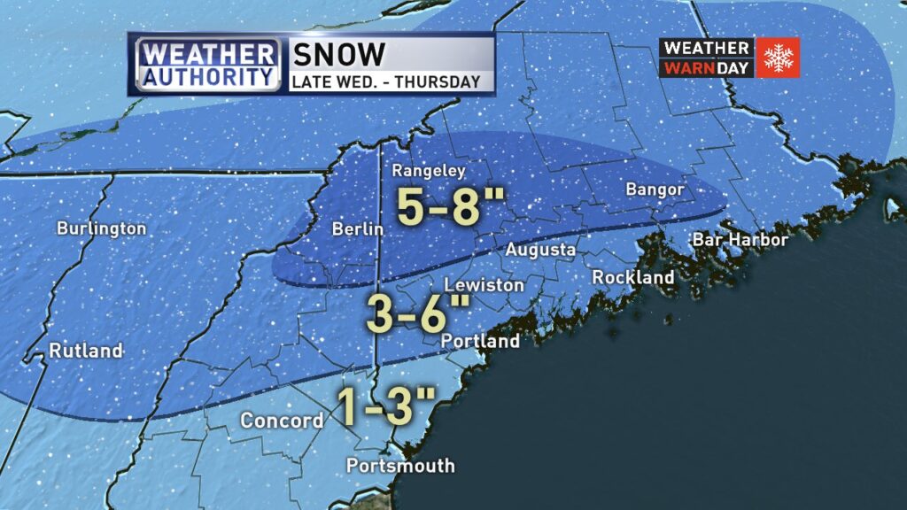
The storm will last through the day Thursday and should drop 3-6 inches of snow for most areas. Western Maine will see higher amounts, about 5-8 inches, and southern York county can expect 1-3 inches.
The system moves out Thursday night.
Clouds move back in this evening with snow arriving after midnight and just in time for the Thursday morning commute! Plan for snowy roads and slow travel tomorrow morning. It starts to wrap up Thursday afternoon but then turning windy and colder via @LexieWGME #WeatherAuthority pic.twitter.com/AaZoumrKH8
— CBS 13 News (@WGME) January 15, 2020
Thursday highs will reach the mid-30s, then temps plunge to only a high in the 10s to around 20 on Friday.
Friday will be sunny, but very cold. It will get below 0 for many that night.
The next round of snow will arrive for the weekend, likely Saturday night through Sunday. This one should drop several more inches across most of Maine.
Right now, it’s looking in the 3-6-inch range, but the storm is still far out and there remains some uncertainty. The Canadian model has been pushing higher amounts. It will also be a windy weekend. Stay tuned.
National Weather Service map
Send questions/comments to the editors.

Success. Please wait for the page to reload. If the page does not reload within 5 seconds, please refresh the page.
Enter your email and password to access comments.
Hi, to comment on stories you must . This profile is in addition to your subscription and website login.
Already have a commenting profile? .
Invalid username/password.
Please check your email to confirm and complete your registration.
Only subscribers are eligible to post comments. Please subscribe or login first for digital access. Here’s why.
Use the form below to reset your password. When you've submitted your account email, we will send an email with a reset code.