


A pedestrian walks down Nichols Street toward Bates College on Thursday morning. Sun Journal photo
The latest round of snow arrived just in time to create problems for Maine commuters. The heaviest snow was expected Thursday morning.
Most of the snow is expected to move out early in the afternoon, but there’s a chance of snow showers and squalls Thursday evening as the arctic cold front drops south.
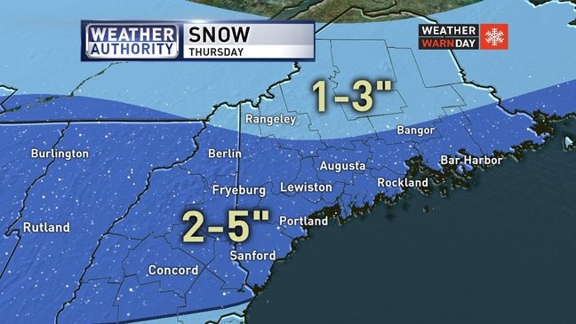
Most communities can expect 2-5 inches snow. However, southern and coastal areas may mix with some rain or freezing rain late Thursday.
Friday and Saturday are going to be bitter cold with highs in the teens and 20s. Saturday morning lows should be 5 to 15 below.
Temps will moderate by the end of the weekend with some 40s likely early next week. A snow shower is possible Sunday. A wintry mix and rain appears to be on the way Tuesday.
WGME map
Send questions/comments to the editors.

Success. Please wait for the page to reload. If the page does not reload within 5 seconds, please refresh the page.
Enter your email and password to access comments.
Hi, to comment on stories you must . This profile is in addition to your subscription and website login.
Already have a commenting profile? .
Invalid username/password.
Please check your email to confirm and complete your registration.
Only subscribers are eligible to post comments. Please subscribe or login first for digital access. Here’s why.
Use the form below to reset your password. When you've submitted your account email, we will send an email with a reset code.