

America’s winter wonderland is starting out this season as anything but traditional.
The calendar says December but for much of the country temperatures beckon for sandals. Umbrellas, if not arks, are needed in the Pacific Northwest, while in the Rockies snow shovels are gathering cobwebs.
Meteorologists attribute the latest batch of record-shattering weather extremes to a stuck jet stream and the effects of a La Nina weather pattern from cooling waters in the equatorial Pacific.
It’s still fall astronomically, but winter starts Dec. 1 for meteorologists. This year, no one told the weather that.
On Thursday, 65 weather stations across the nation set record high temperature marks for Dec. 2, including Springfield, Missouri, hitting 75 degrees Fahrenheit and Roanoke, Virginia, 72 degrees Fahrenheit. Cheyenne, Wyoming, and Billings, Montana, broke longtime heat records by 6 degrees.
Parts of Canada and Montana have seen their highest December records in recorded history. On Friday, parts of South Carolina and Georgia hit record highs.
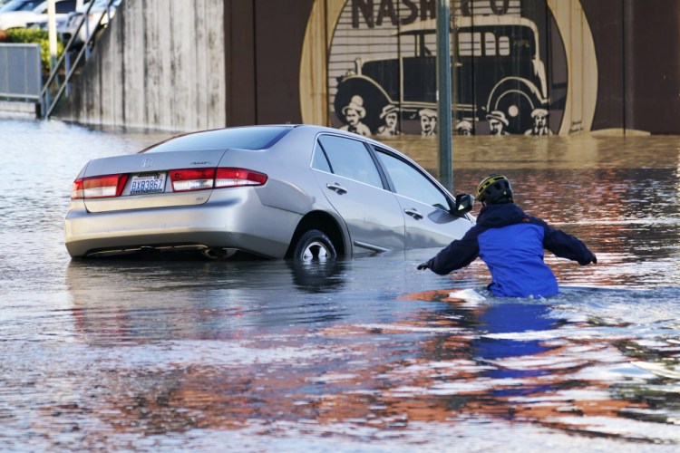
In Washington state, Seattle, Bellingham and Quillayute all set 90-day fall records for rainfall. Bellingham was doused by nearly 2 feet of rain. The Olympic and Cascade mountains got hit harder, with more than 50 inches in three months, according to the National Weather Service. Forks, Washington, received more rain in 90 days than Las Vegas gets in 13 years.
On top of that, there is a blizzard warning on Hawaii’s Big Island summits, with up to 12 inches of snow expected and wind gusts of more than 100 miles per hour.
Meantime, snow’s gone missing in Colorado. Before this year, the latest first measurable snowfall on record in Denver was Nov. 21, way back in 1934. There’s a slight possibility of snow Monday night, according to the weather service. Yet, with no snow since April 22, this is the third longest stretch the city has gone without it.
One big factor: The jet stream – the river of air that moves weather from west to east on a rollercoaster-like path – has just been stuck. That means low pressure on one part of the stream is bringing rain to the Pacific Northwest, while high pressure hovering over about two-thirds of the nation produces dry and warmer weather, said Brian Hurley, a senior meteorologist at the weather service’s Weather Prediction Center in College Park, Maryland.
If the jet stream moves more or bends differently, rain and other extreme weather won’t be as concentrated, Hurley said.
This is a typical weather pattern with a natural La Nina weather oscillation, he said. The flip side of El Nino, a La Nina is a cooling of parts of the central Pacific Ocean that changes weather patterns across the globe. La Ninas tend to bring more rain to the Pacific Northwest and make the South drier and warmer.
These bouts of extreme weather happen more frequently as the world warms, said meteorologist Jeff Masters, founder of Weather Underground who now works at Yale Climate Connections. But scientists haven’t done the required study to attribute these events to human-caused climate change.
In Boulder, Colorado, meteorologist Bob Henson enjoyed a rare December bike ride on Thursday.
Still, “there’s a lot of angst about the lack of snow,” he said. “It puts you in a psychic quandary. You enjoy the warm weather while keeping in mind it’s not good for Earth to be warming.”
Send questions/comments to the editors.

Success. Please wait for the page to reload. If the page does not reload within 5 seconds, please refresh the page.
Enter your email and password to access comments.
Hi, to comment on stories you must . This profile is in addition to your subscription and website login.
Already have a commenting profile? .
Invalid username/password.
Please check your email to confirm and complete your registration.
Only subscribers are eligible to post comments. Please subscribe or login first for digital access. Here’s why.
Use the form below to reset your password. When you've submitted your account email, we will send an email with a reset code.