


A controversy that has swirled for years over a small stretch of the border between Maine’s two oldest towns could soon be settled once and for all.
York and Kittery, normally friendly and cooperative neighbors, have been at odds over whether their shared border is straight or meandering. Maps drawn by each town in 1794 differed slightly, but the discrepancies apparently went largely unnoticed until four years ago.
After a survey of a Route 1 property that straddles the towns made it clear that their placements of part of the border didn’t match, officials from the two towns became locked in a back-and-forth over the exact location of the boundary.
Finally, York filed a complaint Feb. 22 in York County Superior Court asking a judge to appoint commissioners to settle the dispute. Kittery responded by saying no commissioners are needed because the border has been in the right place for well over three centuries. Kittery’s town manager has called York’s push to legally determine the border “an aggressive attempt to take land from Kittery.”
“Kittery will vigorously defend its borders,” Kittery Town Manager Kendra Amaral told town councilors on March 28. “It impacts neighborhoods, it impacts people’s property and the border has been recognized for hundreds of years.”
The border between York and Kittery was established in 1652 by decree from the Massachusetts Bay Colony under threat of force by an armed militia. Maps of the two towns drawn in 1794, a quarter-century before Maine became a state, show the border in slightly different spots.
Those differences weren’t an issue until that survey four years ago, commissioned by a local developer who had bought land along Route 1 that straddles the two towns. The survey found that the town line was 333 feet south of where modern maps show it to be. If the border is moved, that land would become part of York.
York officials think the developer’s survey shows the true straight-line border, but people down in Kittery disagree. The border that they say has been acknowledged for hundreds of years weaves slightly from Eliot to Brave Boat Harbor, they argue.
The dispute centers on land that includes about 300 feet of frontage on Route 1 north of Landmark Hill Lane. The area includes residential parcels, two cell towers and a cemetery. An attorney for Kittery said in court filings that York’s desired modification of the border would affect at least 25 residential properties covering over 300 acres, with a total assessed value of nearly $8 million.
The differences in town maps when they first came to light prompted plenty of lighthearted ribbing about a “border war” breaking out between the two otherwise friendly towns. Town leaders in York joked about building a wall on their southern border, while Kittery residents imagined marching a militia northward.
But the issue is actually a serious one, municipal officials now say, and it needs to be settled.
The land in question is still largely wooded, but is in an area that has been developed in recent years. A border adjustment wouldn’t change anyone’s property ownership, but it would affect where some pay taxes, vote and go to school and which town maintains a cemetery. It could also change how that Route 1 property is developed.
Amaral believes York’s motivation to take this issue to court comes from a single property owner who is looking to develop property around the disputed border and right now has to comply with zoning in both towns. The property owner, who is not identified in town records, “is not happy with what Kittery has said” about how the property can be developed, she told the town council in late March.
Kittery has submitted a Freedom of Access Act request to York for all public records – including letters, emails, texts and social media messages – between town officials and past and present owners of the property at 524 U.S. Route 1. Amaral told the town council she suspects this will give the town a better sense of why York is pressing the border issue now.
A LONG HISTORY
Kittery, incorporated in 1647, is the oldest town in Maine and originally included the towns now known as Eliot, Berwick, North Berwick and South Berwick.
In November 1652, commissioners from the Massachusetts Bay Colony arrived in Kittery, intent on annexing what was then known as the Province of Maine up to modern-day Cape Porpoise. On Nov. 20, 42 inhabitants of Kittery signed a declaration acknowledging they would henceforth be subject to the Government of Massachusetts Bay.
Two days later, the commissioners traveled northeast to Gorgeana, where inhabitants had assembled at the house of Nicholas Davis. By the end of the day, they had taken the same oath as those in Kittery. Georgeana was reincorporated in 1652 as York, named for York, England, and was one of the last Royalist strongholds taken by the Puritans in the English Civil Wars.
Under the Articles of Submission signed in 1652, Massachusetts Bay Colony ordered the towns to set up up their borders. In 1794, Massachusetts insisted that each town create a map because many towns were in disputes over their boundaries. The borders on the maps created that year of Kittery and York did not completely match, but no one seemed to worry at the time.
Plan of Kittery, made by Benjamin Parker, dated November 1794 Massachusetts Archives
The border debate picked up in 2018, after the survey.
The following year, Todd Frederick, chairman of the York Board of Selectmen, sent his counterpart in Kittery a letter outlining York’s position that the border between their towns is a straight line established in 1652. He said the meandering line shown on local tax maps is inconsistent with the legally established border and asked Kittery to work with York to properly identify the “proper straight-line border” or ask the court to settle the matter.
Frederick cited a copy of a report that settled a contested border between York and Eliot to bolster York’s opinion that its border with Kittery is a straight line.
Eliot took York to court in 1991 to establish the boundary between the towns. The three-member commission established by a York County Superior Court judge determined the border between York and Eliot was a straight line.
Kittery officials disagree with York’s opinion that the ruling on the York-Eliot border has any bearing on the current border dispute. The report produced to settle the York-Eliot border issue did not review any historical records after 1810, when Eliot separated from Kittery, and ignored over 200 years of applicable historical record and all of the perambulations required by law, the town attorney wrote last month in a motion to dismiss York’s complaint.
Plan of York surveyed by Daniel Sewall, dated 1794-5. Massachusetts Archives
In a November 2019 response to Frederick’s letter, Judith Spiller, chair of the Kittery Town Council, wrote that the boundaries set forth by the Articles of Submission presented an alternate line to the one that had been used previously and that Kittery has used since. The town council, she said, believes the boundary between the two communities is not the one set forth in those articles but the one noted “in all relevant contemporary and historical documents.
“All U.S. Geological (Survey), State of Maine, Town of York and Town of Kittery maps and documents support the current and historical boundary between our two friendly communities,” she wrote.
Spiller disputed the validity of the border noted in the articles on other grounds as well.
“It is important to note that this particular boundary was established through aggression, imposed by decree from the Massachusetts Bay Colony,” she wrote. “Rife with arbitrary limitations set forth and enforced by armed militia, it reflected neither the established property lines of the times nor those before or after it.”
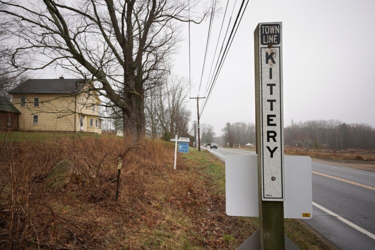
The border between Kittery and York on land along Route 1. Gregory Rec/Staff Photographer
Amaral, Kittery’s town manager, and York Town Manager Stephen Burns each said they can’t comment on the dispute because it is in litigation.
BORDER GOES TO COURT
It is rare that disputes about municipal borders in Maine end up in court, but they are bound to pop up occasionally in a state whose town lines were set hundreds of years ago and often marked with stone walls, tree or granite markers that have long since disappeared.
In the complaint it filed in York County Superior Court in February, York asked the court to appoint three commissioners and empower them to determine the “true and correct” common boundary, describe the boundary line “by curves and distances,” and set markers to indicate the established border.
York argues in its filing that the 1652 description of the common boundary said it began at the head of Brave Boat Harbor and then ran “in a straight line to the head of ye Southwest branch of ye River of York.” The two towns, it said in its complaint, cooperatively identified that straight-line boundary through perambulations, or walking the line, in 1695, 1740, 1779 and 1794.
But the town said that waypoints that marked the boundary caused it to stray from its proper course and become a meandering line, not the straight line between two defined monuments identified in 1652.
Kittery has asked the court to dismiss York’s complaint, arguing that the situation should have been resolved long ago and York has not demonstrated a controversy sufficient to justify judicial review.
No hearings have been scheduled and a decision on the motion to dismiss could be a month or two away.
If the case is not dismissed, the court would likely appoint three commissioners with surveying experience to establish the exact location of the border.
Stephen Langsdorf of PretiFlaherty, who represents Kittery, said he “strongly believes the motion to dismiss will be granted because York did not comply with the requirement that border perambulations to confirm municipal boundaries occur every five years.” That process, which requires representatives of the town to walk the border, was required by law from 1820 to 2003.
“The point of the law was to timely identify any disputes about municipal borders,” Langsdorf said. “In other words, the case should have been resolved 200 years ago.”
Send questions/comments to the editors.

Success. Please wait for the page to reload. If the page does not reload within 5 seconds, please refresh the page.
Enter your email and password to access comments.
Hi, to comment on stories you must . This profile is in addition to your subscription and website login.
Already have a commenting profile? .
Invalid username/password.
Please check your email to confirm and complete your registration.
Only subscribers are eligible to post comments. Please subscribe or login first for digital access. Here’s why.
Use the form below to reset your password. When you've submitted your account email, we will send an email with a reset code.