

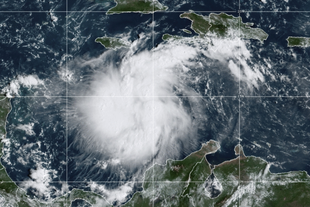
This satellite image provided by the National Oceanic and Atmospheric Administration shows Tropical Storm Ian Saturday over the central Caribbean. NOAA via AP
Tropical Storm Ian is slowly gaining strength as it churns through the northwest Caribbean, set to slam western Cuba before making a northward turn and aiming toward Florida. A period of rapid strengthening is expected to begin in the latter half of Sunday, and could continue through Tuesday as Ian enters the southeastern Gulf of Mexico.
The storm is projected to approach the coast of Florida as a hurricane late Thursday into early Friday, although its landfall location, strength and timing are still uncertain.
Florida is under a state of emergency, which Gov. Ron DeSantis R expanded from two dozen counties to the entire state Saturday afternoon, highlighting the sense of danger and potential for destruction.
“The impacts will be broad throughout the state of Florida,” DeSantis said during a briefing Sunday morning. “Expect heavy rains, strong winds, flash flooding, storm surge, and even isolated tornadoes,” the governor added, saying that residents in the hardest-hit areas should brace for fuel disruptions, power outages and even evacuation orders.
While the storm is most likely to hit Florida’s west coast or panhandle regions, the state’s east coast could see flooding, DeSantis said, although he cautioned that models were still predicting a range of scenarios.
Computer models are divided on whether Ian will come ashore along Florida’s west coast Wednesday into Thursday or nearer the Panhandle on Thursday into Friday.
Uncertainty “in the long-term track and intensity forecast is higher than usual,” the National Hurricane Center wrote Sunday. “Regardless of Ian’s exact track and intensity, there is a risk of dangerous storm surge, hurricane-force winds, and heavy rainfall along the west coast of Florida and the Florida Panhandle by the middle of the week.”
Tropical storm conditions could reach South Florida as soon as early Wednesday and northern Florida by Thursday morning. Ian is predicted to peak as a 130-mph Category 4 hurricane west of the Florida Straits on Tuesday, which would make it the strongest September hurricane to pass through the Gulf of Mexico since Rita in 2005. But the storm’s track and intensity are uncertain as it approaches the U.S. mainland. No alerts have been issued stateside, but it is likely that watches will be hoisted within the next 24 to 36 hours.
President Biden on Saturday approved an emergency declaration for the state, which authorized the Federal Emergency Management Agency to coordinate disaster-relief efforts and provided more federal funding. DeSantis said that he was “thankful” for the Biden administration’s early response.
At 11 a.m. Saturday, Ian was centered 300 miles south-southeast of Grand Cayman, while churning to the west-northwest at 14 mph. Its peak winds were up to 50 mph, a 5 mph increase since Saturday afternoon. The storm will be moving over exceptionally warm waters, which are expected to fuel its intensification. Hurricane warnings are up in Grand Cayman and western Cuba as the storm progresses to the west and northwest. The greater Havana area is under a tropical storm warning.
The storm is expected to become a hurricane by Sunday night or early Monday and reach “major” hurricane strength by late Monday or Monday night before it reaches western Cuba, according to the National Hurricane Center. Major hurricanes are Category 3 or above storms, packing sustained winds above 111 mph.
At greatest risk will be Cuba’s Guanahacabibes Peninsula, a roughly 60-mile-long sparsely populated strip of land at the western tip of the island nation. The Roncali Lighthouse, dating to 1849, has stood sentry at the peninsula’s westernmost point and weathered dozens of hurricanes.
The Hurricane Center estimates that a 9- to 14-foot storm surge could sweep ashore, primarily near and east of the center, where onshore winds push water against the coast. The surge represents a storm-driven increase in water levels above ordinarily dry ground.
Western Cuba also faces 6 to 10 inches of rain and locally as much as 16 inches, potentially triggering flash flooding and mudslides. Heavy rainfall is also forecast over Jamaica and the Cayman Islands, where 4 to 8 inches is possible.
The storm’s path is still uncertain, but it appears headed to make landfall near the Florida Panhandle on Friday. Even before then, the Florida Keys and southern and western Florida are expected to get 2 to 4 inches of rain, with up to 6 inches possible through Wednesday morning.
The uncertainty in the forecast stems from an approaching trough, or dip in the jet stream, over the northern United States. Ian may or may not hitch a ride. If it does, it would be scooped north and east more quickly and come ashore as a more serious hurricane in the Florida peninsula on Wednesday.
If it “misses” its ride, so to speak, it will meander northward, likely arriving in the northern Gulf of Mexico, when there will be an uptick in disruptive wind shear, or changing winds with height, and dry air.
In that scenario, weakening would occur before the storm makes landfall closer to Friday morning, but Ian could still come ashore as a Category 1 hurricane. In this case, its greatest hazard would shift away from destructive winds and more toward storm surge. Because of the shape of the sea floor in the northeastern Gulf of Mexico, even low-end hurricanes can bring a dangerous storm surge.
As the storm is drawn north late in the week into the weekend, the Southeast and Mid-Atlantic may also see heavy rainfall, along with a few tornadoes as the high-altitude spin of the storm passes, even after it loses hurricane status.
Ian is the sixth named storm to form this month, coming on the heels of a record-quiet August, during which not a single named storm formed. According to Colorado State University hurricane researcher Philip Klotzbach, only eight other Atlantic hurricane seasons, including each year between 2018 and 2021, have featured the formation of six or more named September storms.
Atmospheric scientists note that there does not exist a link between the number of named storms and human-induced climate change. However, those that form are expected to be wetter and more intense, and will be more prone to rapid intensification, because of rising ocean temperatures.
Copy the Story LinkComments are not available on this story.
Send questions/comments to the editors.
