

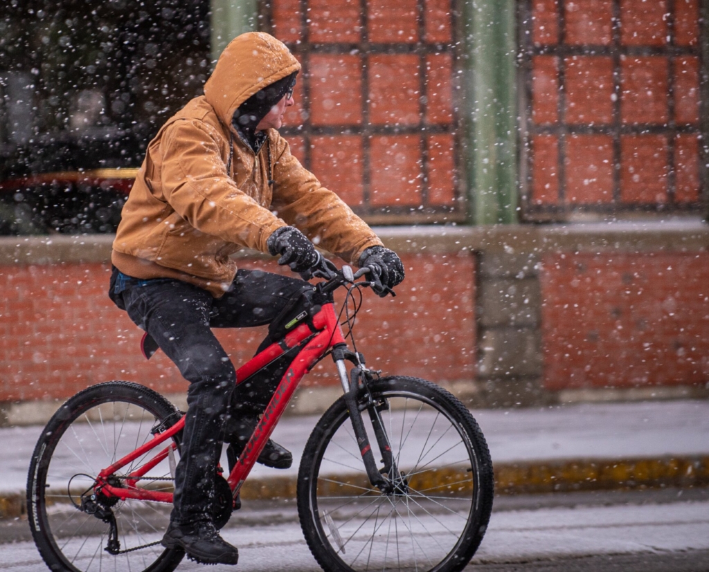
A man on his bicycle looks for cars Friday afternoon as the snow starts coming down harder as he crosses Bates Street in Lewiston. Russ Dillingham/Sun Journal
Snow and rain arrived in the region Friday afternoon and chaos came with it.
Snow began to fall at about 1 p.m. in the area and a long string of car crashes soon followed.
As roads became slick around 1 p.m., wrecks were reported almost immediately in West Paris, Rumford, Brownfield and Fryeburg, all within about a half hour’s time. At 2:45 p.m. a rollover crash was reported in Minot, with all occupants reported to be out of the vehicle. A van slid off a snow slicked road in Poland shortly before 3 p.m. and a few minutes later, a car slid into a pole nearby.
A crash was reported on Oak Hill Road in Monmouth shortly at about 3 p.m. and a wreck in Turner occurred a short time later. In Naples, on Sebago Road, a car flipped onto its roof at about 3:30 p.m. In Fryeburg around the same time, it was the same scene on Route 5: car overturned, occupants uninjured but trapped within the wreckage.
No serious injuries were reported in most of the wrecks, but at about 4:15 p.m., a rollover crash was reported on Pownal Road in Auburn, with the driver reported to be bleeding from the head and partially pinned between the door and the truck frame. Passersby were able to free the man’s head and to prevent the truck from rolling further until rescue crews arrived.
The driver, William Hotham, 62, of Auburn was taken to a Lewiston hospital to be treated for minor injuries. Police said he had lost control of his 2006 Ford F150 due to road conditions and inadequate tires.
In Wales, after a driver slammed into a utility pole at about 4:30 p.m, bringing it down on Litchfield Road, police closed the roadway so that power crews could make repairs. The road was expected to be closed into Saturday morning.
Around the same time as those wrecks, crashes were reported on Greenwood Road in Peru, on Granite Street in Mexico, on Watson Road in Norway, on Snow Hill Road in New Gloucester and on North Parish Road in Turner.
At about 7 p.m. on Lake Street in Auburn, a driver slid into a pole and brought it down, prompting police to shut down a section of the road between Colonial Way and Hotel Road.
Also around 7 p.m., a tractor trailer slid into a building on South Main Street in Woodstock bring emergency crews to the scene.
On it went into the evening, with police, fire and rescue crews responding to one crash after another just about everywhere.
Will Williams shovels the sidewalk and driveway of his home Friday afternoon on Pine Street in Lewiston. “I’m in my 80s so I try to stay ahead of it so it doesn’t get too deep, especially where the plow goes past. I try to come out every hour or two.” Russ Dillingham/Sun Journal
In addition to rain and snow slicking the streets, the temperature of the roads themselves had dropped down to near freezing so patches of ice were developing in areas. As is usually the case during winter storms, the best advice Friday afternoon was to stay off the roads.
“If you don’t have to go anywhere, avoid it,” Mike Haggett, of Pine Tree Weather, wrote on Twitter. “If you do, be prepared for a long ride. Conditions to get worse overnight.”
From the beginning, the predictions were for a sloppy, wet and difficult storm. By Friday afternoon, all that was coming to fruition and the storm was only getting started.
By mid-day Friday, a lot remained to be seen. In some areas, there was the possibility of a mostly rain event while other regions were expecting a foot or more of snow.
“The mountains will get a good one out of this,” Haggett wrote Friday morning. “South and east of there, many questions remain, with bust potential on the high and low end pending on how far inland the coastal front goes. The gradient between the haves and have nots for snow could be stark. Conditions over western areas deteriorate during the day as snow piles up, with some areas seeing as much as 6 inches on the ground by evening.”
The National Weather Service in Gray advised that mass power outages were likely as strong winds coupled with wet snow to wreak havoc on poles and power lines.
Chuck Smith, of Lewiston Public Works, sits patiently in his truck Friday at Simard Payne Memorial Park for the snow to accumulate. “We thought it would start earlier,” Smith said. “The ground was so warm that it took longer to start accumulating.” Andree Kehn/Sun Journal
Winds began to pick up shortly before 3 p.m., causing further potential for power outages as tree limbs and power lines, becoming thick with wet snow, threatened to topple. At Central Maine Power, crews were ready to roll.
“This storm may bring heavy wet snow that loads up limbs and power lines and gusty winds that can bring trees and limbs down onto lines and utility poles. If the storm creates power outages, we are prepared,” said Kerri Therriault, senior director, Electric Operations. “In addition to our own 200 lineworkers we have 166 contractor lineworkers and 120 tree crews on deck to restore power.”
By 7 p.m., only scattered outages — slightly more than 2,000 — were reported around the state. In Oxford County there were 604 homes and businesses without power. In Androscoggin County, there were two.
In Lewiston and Auburn, school classes were canceled early Friday for fear that the end-of-day bus routes might be vexed by bad road conditions. All state offices were closed, too, in anticipation of the storm. A winter storm warning was in effect into Saturday night and parking bans were in place in most cities and towns for the same period.
In New Hampshire, meanwhile, several areas had already seen ten inches of snow and it was still falling. In Maine, by 5 p.m., snowfall totals were all over the place. In Porter, in Oxford County, 7 1/2 inches were reported, while Denmark only had two. In Lewiston, less than an inch of snow had fallen around the same time and it was only beginning to accumulate on the roads at about 6 p.m.
The season’s first big storm is expected perhaps to overstay its welcome, and Mainers looking for relief from it all are likely in for a long wait.
“Reminder,” Haggett Tweeted, “This isn’t a storm that when you get up tomorrow it will be over and done. This is going to go on all day Saturday. For the mountains, east and north, it may not end until Monday.”
And if that isn’t enough winter for you, Haggett says there’s also potential for a storm next Thursday and Friday, just ahead of Christmas.
Copy the Story LinkSend questions/comments to the editors.

Success. Please wait for the page to reload. If the page does not reload within 5 seconds, please refresh the page.
Enter your email and password to access comments.
Hi, to comment on stories you must . This profile is in addition to your subscription and website login.
Already have a commenting profile? .
Invalid username/password.
Please check your email to confirm and complete your registration.
Only subscribers are eligible to post comments. Please subscribe or login first for digital access. Here’s why.
Use the form below to reset your password. When you've submitted your account email, we will send an email with a reset code.