


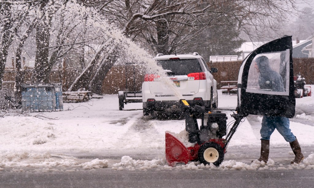


A slow moving nor’easter intensified throughout the day Tuesday and by late afternoon began delivering the punch forecasters had predicted, creating treacherous driving conditions and leaving thousands of Mainers without power.
The late-winter storm packed wind gusts of up to 50 mph. Combined with wet, heavy snow, the weather conditions wreaked havoc Tuesday night with tree branches falling on power lines. By 9:30 p.m., nearly 75,000 Central Maine Power Co. customers had lost power, according to the company’s outage website.
As of 2:30 p.m. Wednesday morning, CMP reported more than 29,000 customers were still without power, including 2,751 in Cumberland County, 6,352 in York County and 8,176 in Knox County.
As the storm intensified, snowfall amounts rose steadily, especially in York County. Shapleigh reported 10 inches of snow at 6 p.m., Hollis 6.8 inches, Baldwin 6.5 inches and Kittery 4.5 inches, according to totals gathered by the National Weather Service. Pownal reported the highest snowfall total for Cumberland County with 3.9 inches. The Portland International Jetport had recorded 1.7 inches by early evening.
Parts of southern New England were expected to receive more than 2 feet of snow, but most of Maine will miss out on those high totals. By the time the storm wraps up Wednesday, Portland was expected to receive up to 10 inches of wet, heavy snow, while other areas of the state could top a foot.
New Hampshire dealt with much heavier snow as bands moved inland from the coast and dropped as much as 3 inches of snow an hour, National Weather Service meteorologist Andy Pohl said.
Parts of New Hampshire had already gotten buried by Tuesday evening, according to the National Weather Service. Peterborough reported 29 inches of snow, Greenville 24 inches, and Concord 13.2 inches.
STORM TO TAPER OFF WEDNESDAY
Forecasters said the snow would continue to fall until early Wednesday but the high winds should start to ease shortly after midnight. The Portland Buoy recorded winds as high as 45 mph Tuesday, Pohl said, and the Isle of Shoals saw a gust of 51 mph.
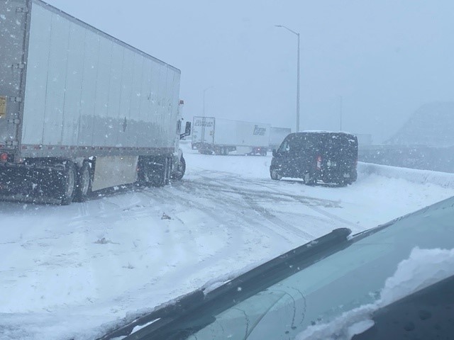
A number of slide-offs were reported, with one of the most serious involving a fuel truck in Standish.
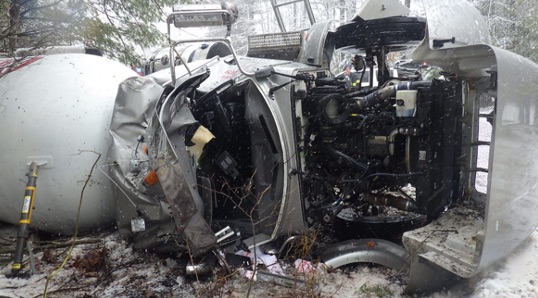
A fuel truck crashed near 174 Saco Road in Standish on Tuesday. Photo courtesy of Cumberland County Sheriff’s Office
The truck driven by 46-year-old Aaron Turlis of Limerick crossed the center line into the northbound lane of Saco Road before it drove into a ditch and rolled over, but did not spill any fuel. Turlis was extricated from the wreckage and transported to Maine Medical Center for treatment of non-life threatening injuries.
Saco Road was closed to traffic for several hours before reopening just before 4 p.m. Police said the weather and slippery road conditions appear to have been a factor in the crash.
At 11:17 a.m. the speed limit on the Maine Turnpike was reduced to 45 mph.
Maine State Police responded to two crashes Tuesday morning on the turnpike in Wells, including a rollover at Mile 18 southbound that injured the driver. Troopers said both drivers were traveling too fast for road conditions.
Travel continued to worsen Tuesday afternoon as the storm gained strength. The Associated Press reported whiteout conditions in New Hampshire with state police asking drivers to stay off roads. New Hampshire State Police responded to more than 120 accidents Tuesday afternoon.
ACCIDENT CLOSES BRIDGE
A tractor-trailer truck jackknifed on the Piscataqua River Bridge on I-95 in Kittery, Tuesday afternoon. Photo courtesy of Maine State Police
In Kittery, the northbound lanes of Interstate 95 on the Piscataqua River Bridge were closed just after 4 p.m. Those northbound lanes reopened around 5:30 p.m.
Shannon Moss, spokesperson for the Maine Department of Public Safety, tweeted that weather conditions “made it tough” for three tractor-trailer trucks to cross over the bridge. In a photograph tweeted by Maine State Police, it appears that at least one of the tractor-trailers jackknifed while trying to cross the bridge.
Moss said that state troopers, who are assigned to patrol the Maine Turnpike, responded to 29 slide-offs or crashes during Tuesday’s storm.
In Woodstock, a town in Oxford County, authorities reported that a truck crashed into a home just before 6 p.m. at 4 South Main St. Additional details were not available.
The weather service warned people to prepare for power outages because of the wet, heavy snow and high wind gusts along the coast.
On Monday, CMP had said it was “pre-staging additional line and vegetation management crews across our service territory” to prepare for the possibility of outages.
The storm prompted a slew of delays and cancellations. Anticipating heavy snow by lunchtime, many school districts in southern Maine either canceled classes for the day or called for a remote-learning day.
Courts in Cumberland and York counties were closed, as were many town offices and libraries. Gov. Janet Mills ordered all state offices closed Tuesday and encouraged Mainers to not drive unless they have to.
Nearly three dozen flights in and out of the Portland jetport had been canceled by early evening and more delays and cancellations were expected, said Zachary Sundquist, assistant jetport director. Because most arriving airliners stay at the airport overnight and fly out in the early morning, he said, that could lead to more cancellations Wednesday.
Concord Coach Lines closed its Bangor bus terminal at 12:45 p.m. and several trips between Portland and Boston were canceled. The Amtrak Downeaster also canceled four trips Tuesday.
Portland declared a citywide parking ban from 10 p.m. Tuesday through 6 am. Wednesday. Other communities with parking bans include Scarborough, Falmouth, Gorham, Old Orchard Beach, Sanford and Cape Elizabeth.
Send questions/comments to the editors.

Success. Please wait for the page to reload. If the page does not reload within 5 seconds, please refresh the page.
Enter your email and password to access comments.
Hi, to comment on stories you must . This profile is in addition to your subscription and website login.
Already have a commenting profile? .
Invalid username/password.
Please check your email to confirm and complete your registration.
Only subscribers are eligible to post comments. Please subscribe or login first for digital access. Here’s why.
Use the form below to reset your password. When you've submitted your account email, we will send an email with a reset code.