

It’s the heart of winter, but the Mountain West is mired in a widespread snow drought.
Although snow season started strong in some spots, it has since flatlined. Ski resorts in Utah are running on limited terrain. Idaho and Montana mountains are hurting for snow. So is the Pacific Northwest. The Sierra just picked up some to open the year, but it needs a good deal more to get out of the rut.
Some areas have less than a third of the amount of snow that they should have in January. And many individual stations are registering record low snow numbers, according to Dan McEvoy, a climatologist for the Desert Research Institute and the Western Regional Climate Center in Reno, Nev.
The snow situation “is not very good right now compared to recent years and even compared to the past several decades,” McEvoy said. “It’s a pretty big deal to be at those record-low values this time of year.”
Warmer temperatures and a lack of moisture-rich storms, or some combination of the two, are driving the low snow conditions.
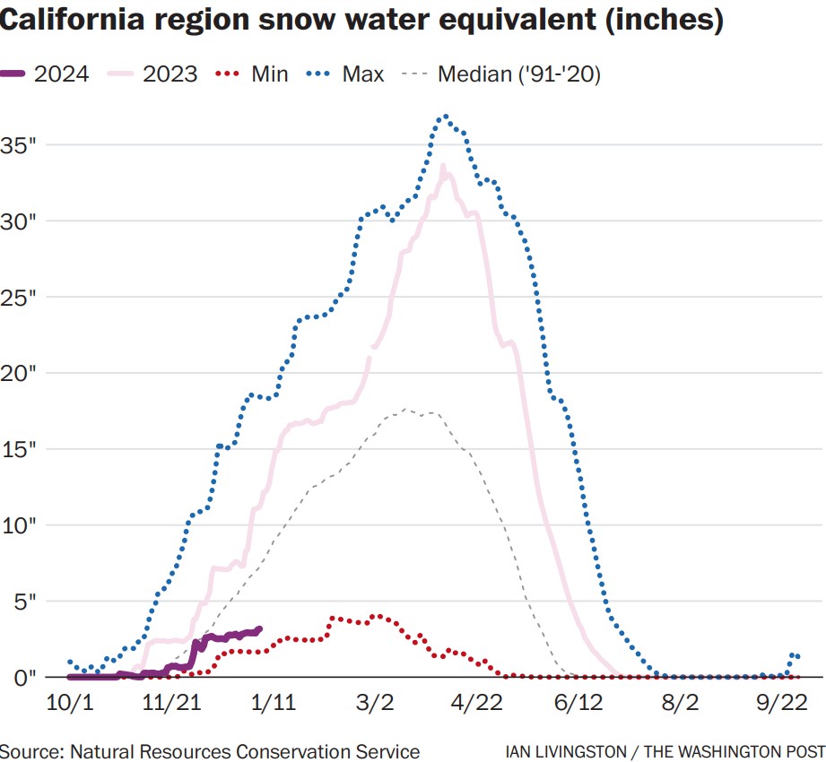
SNOW DROUGHT IN THE WEST
While simple snow depth is often key for winter aficionados, climate knowledgeable Westerners are frequently examining the snow water equivalent (SWE), which is a measure of the amount of water contained in the snow. Depth and SWE tend to go hand in hand, but it is the water content that matters.
A glance at the current SWE map quickly highlights an all-encompassing deficit.
Even with a small uptick in recent days, the California region SWE is less than half the normal value for the date, according to the U.S. Agriculture Department’s Natural Resources Conservation Service. The SWE of 3.2 inches on Jan. 4 compares to the normal 7.2 inches. In what became a historically snowy winter, last year the SWE was 11.2 inches on the same date.
Snow conditions in the Central Rockies are only slightly better. The SWE for the Upper Colorado region is about 65% of normal.
Smaller subregions are even worse off.
A western Oregon zone is at 27% of normal for the date. The southern Sierra Nevada and ranges just to the east are at 34% of normal. In the eastern ranges of the Rockies, northern Montana is as low as 36% of the norm.
BARE GROUND IN CALIFORNIA
For California’s first snow survey of the season on Tuesday, officials navigated patches of bare ground at Phillips Station near Lake Tahoe. They measured just 7.5 inches of snow depth and only 3 inches of snow water equivalent.
“Here at Phillips last year on this date, we were standing on almost 5 feet of snow, so vastly different than what we are standing on here today,” said Sean de Guzman, manager of snow surveys and water forecasting with the California Department of Water Resources.
The statewide picture is similar, sitting at just a third of normal, with only about 3 inches of snow water equivalent.
Last year at this time, Sierra snowpack was 186% of normal and held nearly 18 inches of water. Feet of snow had already fallen earlier in December 2022. And California was in the midst of a three-week barrage of atmospheric rivers that would ultimately dump about 32 trillion gallons of water and up to 20 feet of mountain snow.
At the Central Sierra Snow Lab at Donner Pass, Calif., October through December snowfall in 2023 was the fourth-lowest since 1971.
“No horrible records just yet, but we are certainly scraping the bottom of the barrel at this point,” Andrew Schwartz, lead scientist and manager of the lab, said in an interview.
What’s been missing? Last year’s big moisture stream – and the cold air.
“Last year was a bit wild because we started out above average and then with each passing storm, we just kept getting higher and higher above average – there was no real reprieve,” Schwartz said. “This year, we’re constantly wanting these larger storms that just aren’t making landfall.”
WHAT’S BEHIND THE LOW SNOW?
As is typical in strong El Niños, the atmosphere is juiced with subtropical moisture, and the weather pattern is active. But an expansive upper-level high pressure centered over south-central Canada has extended into the Western United States. This helped block the most significant storminess just off the West Coast.
Warmer temperatures have also played a big role. In the Pacific Northwest, for example, snowpack is depleted despite a wet start because of warmer storms in December, McEvoy said.
December temperatures were much above normal across the West, amid record warmth for the United States. That’s thanks to the long-term warming trend, combined with a boost from El Niño this year – mild Pacific Ocean air has regularly flooded the Lower 48.
Mountain snow in the West has seen a clear and dramatic decline since the 1950s because of global warming. And multiple snowless or nearly snowless years in a row could become the norm as early as the 2050s.
California is also seeing more precipitation falling as rain in the autumn and spring, Schwartz of the Central Sierra Snow lab said.
“Our snow season is shortening because we do see rainfall rapidly becoming the predominant precipitation type in those early and late season months,” he said.
CAN THE WEST CATCH UP?
The good news is that the West has entered a colder pattern, and more substantial snow may be piling up over the next week or so. Still, for real recovery, there needs to be a persistent and strong moisture tap as well, according to McEvoy of the Desert Research Institute.
“We’ll need a larger-scale change in the circulation pattern to allow that southern branch of the jet stream to merge with these colder storms that drop down from the north,” he said.
The current weather pattern into mid-January should tend to favor snowy conditions in the Sierra, with better odds of above-average precipitation increasing to the north. Around mid-month, there are some signals that even wetter times will arrive for the Golden State. But it may be that, on average, warmth rules for the West and into Canada, as seen recently.
“It’s still early – there is time to recover,” McEvoy said. “But it gets harder to dig out of that hole as you get into January and to the middle of the winter when you are already in such a big deficit.”
Copy the Story LinkSend questions/comments to the editors.

Success. Please wait for the page to reload. If the page does not reload within 5 seconds, please refresh the page.
Enter your email and password to access comments.
Hi, to comment on stories you must . This profile is in addition to your subscription and website login.
Already have a commenting profile? .
Invalid username/password.
Please check your email to confirm and complete your registration.
Only subscribers are eligible to post comments. Please subscribe or login first for digital access. Here’s why.
Use the form below to reset your password. When you've submitted your account email, we will send an email with a reset code.