


This photo of the Flood of 1953 looks west on Route 2. Television repairman, Clayton Sweat’s home is the white one to the left with Lover’s Lane past his house. Note the person in the rowboat. The Annis Family
BETHEL — Parts of Bethel were flooded twice in 2023 from rain and also from the Androscoggin River.
On April 2, 1953, a Bethel Citizen article tells a familiar story.
The Androscoggin River, “went on its wildest rampage since 1936. Friday, following three days of rainfall. Rapidly rising waters forced families at Skillingston and above Mayville to leave their homes and there was no passenger train bus service on Friday and Saturday,”
Further along in the story they note that a crew removed motors at Richard Davis’ sawmill and equipment and supplies from Bennett’s lower garage, “and Ruth Carver Ames’ oil storage tanks were taken up the street.”
The story says, that “for some time,” Bethel was shut off from the outside.

The Flood of 1953. The big house at the center of the frame is the old Norseman Inn just before North Rd. The bridge has since been replaced. The Annis Family
Mighty Androscoggin
The 169 mile long Androscoggin River flows through the Bethel area from the headwaters in Umbabog Lake in Errol, NH to it’s mouth at Merrymeeting Bay, bordered by Brunswick, Bath, Topsham, Bowdoinham, Dresden and Woolwich.
The online collection of the Museums of the Bethel Historical Society details several floods or freshets – water flows resulting from sudden rain or melting snow – through the years.
This preface leads the listing, “In more recent times, the construction of dams to control the river’s flow during periods of high water has been of tremendous aid to those residing or working near the waterway.”
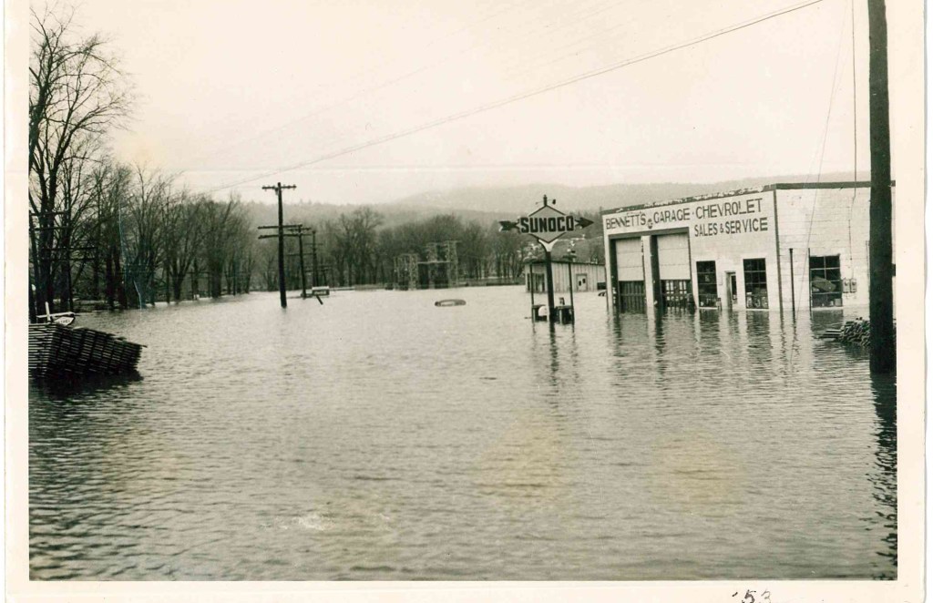
The Flood of 1953. Bennett’s on the right is now the SAD 44 bus garage at the bottom of Main Street The CMP substation is further back on the right. The Annis Family
1723 – The earliest recorded “freshet” on the Androscoggin occurred in February. The river was “open not only below but even to the falls thirty miles above Pejepscot” (Brunswick/Topsham).
1784 – In the autumn of this year, high water lifted the barn of Andrew and John Dunning, of Brunswick, off its site on the intervale and carried it intact until it reached the falls.
1785 – In October, “the greatest freshet ever yet recorded on the Androscoggin River” damaged or destroyed many low-lying houses and farmstead from Bethel to Brunswick.
1826 – On August 30, “the most unexpected and rapid rise of water in the Androscoggin occurred that had ever been known. In Livermore and Jay the water rose eight feet in one night.” A number of mills were damaged and ferries swept downstream.
1839 – A February “ice freshet” carried away dams, log booms and mills on the river. The open-truss pier bridges at Bethel and Rumford Point were also destroyed and replaced with ferries the following year.
1869 – In the “Pumpkin Freshet” of October 5, thousands of pumpkins were carried into the Androscoggin River via its tributaries, creating a sight long remembered by valley residents.
1896 – A March flood forced thick cakes of river ice over roads and against bridges, causing much damage. Railroad tracks near the river were undermined and telephone lines in the Bethel area brought down.
1927 – Several days of torrential rain during November resulted in high water along major waterways in Maine, New Hampshire, and Vermont. Damage and loss of life was greatest in the latter state.
1936 – Heavy rains in mid-March combined with spring snow melt to produce what has been called “Maine’s greatest flood.” Considerable property damage occurred throughout the Androscoggin valley.
1953 – Despite record runoff, the late March 1953 flood caused less damage than in 1936 due to the absence of ice jams and moving ice. “The discharge of the Androscoggin at Auburn was the second largest since 1850 and probably since 1785.”
1981 – Rains lasting several days in February caused the Androscoggin to overflow its banks, resulting in numerous ice jams on the narrower sections of the upper river.
1987 – On April 1, the worst flooding in Maine in half a century was brought about by melting snows and driving rain. Entire sections of communities along the Androscoggin were cut off as bridges washed out and roads were submerged.
The photographs here were taken by Louise or Oscar Annis. They were contributed by Wendy and Scott Annis. Scott, at age one, was too young to remember The Flood of ’53.
Send questions/comments to the editors.

Comments are no longer available on this story