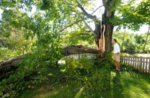
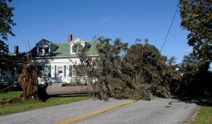
LEWISTON — Irene brought more wind than rain to Maine, scattering branches and knocking down trees and power lines across Androscoggin, Franklin and Oxford counties.
The work kept emergency and public works crews busy in Lewiston and Auburn through the day Monday.
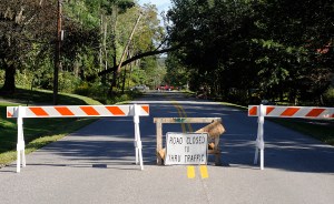
“We’d go to one street, remove tree branches or put up a barricade and move on,” said Lewiston Police Sgt. Joseph Bradeen. “We’d go back later on and take the barricade down.”
Early Monday morning, three streets in Lewiston were closed — Pinewoods, Deer and Ferry roads — but “most of the problems are limited to the outskirts,” Bradeen said.
A number of Auburn roads closed because of tree limbs Monday morning, including Pownal Road to the town line, Turner Street near Central Maine Community College, North Auburn Road, Winter Street, Stevens Mill Road at Howe Street, Towle Avenue and Harvard Street. Riverside Drive was down to one lane near Bell Farms due to downed tree limbs. Other roads, including Perkins Ridge Road and Marston Hill Road, were also blocked by downed trees, frustrating motorists and slowing traffic.
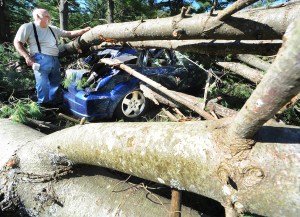
In Sabattus, trees fell on a cluster of four homes on Park Street, and one tree crushed a car parked near one of the homes.
Jim Dion of 64 Park St., was home Sunday when he heard a “crack” and looked out to see his 2009 Dodge caliber crushed under a couple of trees. Minutes before, the neighborhood had lost power when a tree down the street fell onto wires, exploding a transformer and then pulling the wires so hard the pressure snapped another pole down the street.
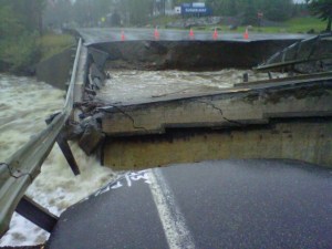
In Carrabassett Valley, about 100 people remained stranded at Sugarloaf Monday, according to Police Chief Scott Nichols, after two bridges on either side of the resort’s access road off Route 27 washed out, leaving guests and employees no way to drive away and no way for first responders to drive to the mountain resort.
Without the bridge access, the only entrance or exit for mountain guests and employees will be by foot until temporary access through Brackett Brook Road can be shored up to get passenger vehicles in and out, said Emergency Management Director Tim Hardy.
Route 27 is closed indefinitely north because of a washout just north of the Sugarloaf Access Road. One bridge next to Carrabassett Valley Academy is gone and there’s a 25 yard hole about 20-feet deep taking its place, Nichols said.
A bridge to the access road had washed out and there is concern about Route 27 around what is called the “S” turns. The road is leaning into the river, he said.
“It looks like a war zone up here. It’s worst than 1987 when the April 1 ice storm pounded here,” he said.
The area around the “S turns” on Route 27 is normally above the flow of water but on Sunday that water went over the road, Nichols said.
Sugarloaf Mountain will try to get access to Sugarloaf Village through one bridge that’s on private property, but it needs to be shored up first, he said.
Hardy thought the road might be in place by mid-day Monday. And, the Maine Department of Transportation will put in a temporary bridge on Route 27, but the road will probably be closed for most of the week, Hardy said. Traffic will have to reroute over Route 16 to Rangeley.
In Lovell, a house was destroyed by fire very early Monday, and wires were down across many roads throughout that region. At least three houses in Oxford were damaged by falling trees, including homes on Main Street, School House Road and Whittemore Road.
Meanwhile school officials called off the first day of school at the Oxford Hills School District as residents worked on cleaning up debris and repairing damages.
In Bethel, police were called to assist with traffic control on Route 2 to keep cars from bypassing a sign urging motorists to avoid the road because of accumulated water there. And, in Rumford, horses had to be rescued from a field as morning dawned and, later in the day, a public works crew worked to salvage a Porta Potty floating on the flooded Hosmer Field.
Although a number of communities opened temporary emergency shelters at schools and town halls, few of the shelters were occupied overnight Sunday.
Two residents went to the American Legion shelter in Oxford, according to Allison Hill and Teresa Inman at the Oxford County Emergency Management Agency headquarters in Paris. And, by mid-afternoon Monday, most of the state’s emergency shelters had closed, but the shelter at Mountain Valley High School in Rumford remained open.
In advance of the storm, the Maine Department of Conservation closed 27 coastal state parks and historic sites, and most were re-opened Monday.
The parks and sites sustained some damage to trees and shorefronts, but no buildings or facilities were damaged, according to officials with the Maine Bureau of Parks and Lands.
Mackworth Island at Falmouth is expected to re-open Tuesday, after tree damage on the trail is cleared, and Sebago Lake State Park will remain closed until at least Wednesday while crews clear extensive tree damage and downed power lines.
Throughout the day Monday, Maine’s major rivers — including the Androscoggin and Kennebec — remained under flood warnings, according to the National Weather Service in Gray.
The Androscoggin River for much of its northern and western stretches remained under a flood warning, including areas in Coos County, N.H., and Oxford County.
In Auburn, the river level was 12.8 feet on Monday morning, and rising above the 13-foot flood stage by the afternoon, with minor flooding forecast. The Weather Service anticipates the river will rise to nearly 14.3 feet just after midnight Tuesday, before dropping to pre-flood level by Wednesday morning.
The Androscoggin River at Rumford was at 15. 2 feet Monday at 5. a.m. Flood stage for the river there is 15 feet and the river had reached that point but was expected to begin to recede by late morning.
Also on the warning list was the Carrabassett River in Franklin County.
Early Monday, the Kennebec River was at 8.1 feet, and its flood stage is 12 feet. The forecast was for the Kennebec to exceed flood stage by late morning and to continue to rise. The forecast has the Kennebec reaching 17 feet by Tuesday evening.



Comments are no longer available on this story