

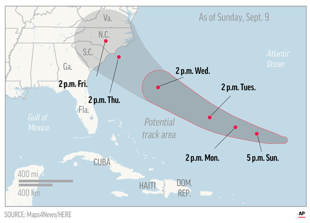
Hurricane Florence is tracking toward the East Coast with an invariability rarely seen in storms several days away from making landfall. While forecasters were careful to cite “high uncertainty” and “low model confidence” last week, their tone changed after several days of watching the storm’s eventual path barely shift from what they had considered the worst-case scenario.
On Sunday evening, the National Hurricane Center was forecasting Florence to become a strong Category 4 hurricane just before making landfall Thursday somewhere on the Southeast or Mid-Atlantic coast.
Know what’s happening, when it’s happening
With each passing flight into the eye of the storm and every new forecast from the global weather models, it is increasingly unlikely that Florence will turn out to sea and spare the Eastern Seaboard a potentially devastating storm surge, flooding and wind.
There’s even some indication that the hurricane will slow or stall out over the Mid-Atlantic later this week, which could lead to a disastrous amount of rain – turning Florence into the Mid-Atlantic’s Hurricane Harvey.
“There is an increasing risk of two life-threatening impacts from Florence: Storm surge at the coast and freshwater flooding from a prolonged heavy rainfall event inland,” the National Hurricane Center wrote Sunday. Storm surge is the rise in ocean water above normally dry land at the coast, which can inundate homes, roads and businesses. Freshwater flooding is caused by torrential rain that overwhelms streams, rivers and reservoirs.
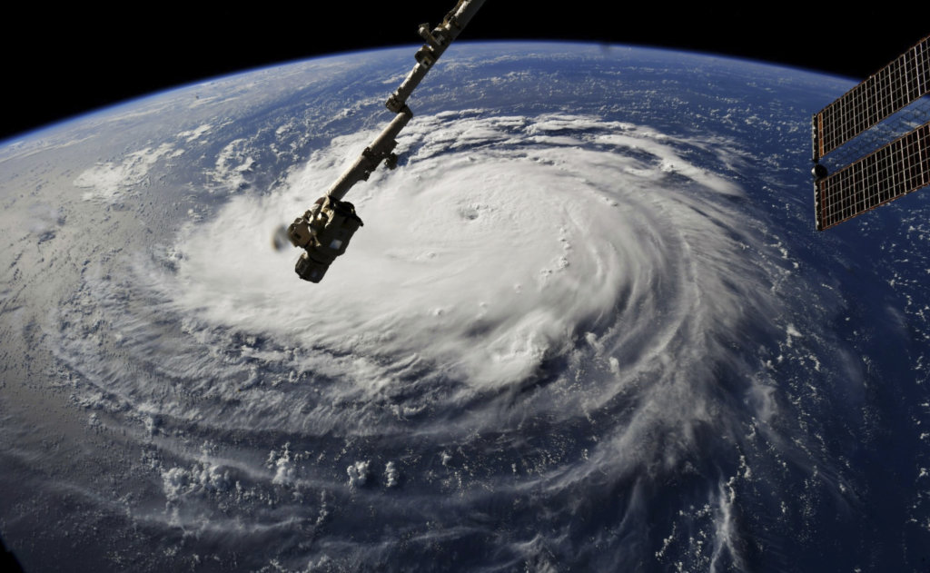
This photo provided by NASA shows Hurricane Florence from the International Space Station on Monday, Sept. 10, 2018, as it threatens the U.S. East Coast. Forecasters said Florence could become an extremely dangerous major hurricane sometime Monday and remain that way for days. (NASA via AP)
Multiple states are bracing for a dangerous storm.
In North Carolina, officials have raised red flags along the Outer Banks, telling beachgoers to avoid the ocean, and ferries from islands off the state’s coast have been canceled. The waters off the coast are showing signs of the hurricane in the form of large sea swells and life-threatening currents.
“Everyone in North Carolina needs to keep a close eye on Florence and take steps to get ready for impacts later this week,” Gov. Roy Cooper, D, said in a statement. “I urge the public to review your emergency plans and gather your supplies now.”
In South Carolina, officials surmise that the state will be inundated with strong rains and high winds no matter where the storm makes landfall, and they urged citizens to prepare to evacuate.
“Make your plans now. You have to get your medicines ready to go, if you have prescriptions you need to get filled . . . Make sure you lock things up, because you may not be coming home for several days,” Gov. Henry McMaster, R, said at a news conference Sunday.
“Pretend, presume and assume that a major hurricane is going to hit smack dab in the middle of South Carolina,” he added.
The North Carolina governor declared a state of emergency Friday. The governors of South Carolina and Virginia followed suit Saturday.
In Virginia, officials expect significant flooding along the coast and in rivers and streams in the western part of the state and urge residents to avoid driving across flooded roads.
On Sunday evening, Florence was crawling west-northwest across the North Atlantic Ocean at just 7 mph. Its peak winds were 85 mph, making it a Category 1 hurricane. Over the coming days, its forward motion is expected to increase as it turns to the west-northwest, and its intensity is expected to rapidly increase.
But the storm is predicted to slow as it approaches a likely landfall. Forecasts show that Florence could sit over some part of the Mid-Atlantic for several days, similar to what Harvey did last year over eastern Texas. It has the potential to dump more than a foot of rain – some forecasts suggest more than 30 inches – over a large area in the Mid-Atlantic and perhaps into the Northeast.
The region will be particularly susceptible to flooding because of above-normal rainfall in the region since May. In addition, because the ground is likely to be saturated, trees will be vulnerable in the strong winds.
Copy the Story LinkSend questions/comments to the editors.

Success. Please wait for the page to reload. If the page does not reload within 5 seconds, please refresh the page.
Enter your email and password to access comments.
Hi, to comment on stories you must . This profile is in addition to your subscription and website login.
Already have a commenting profile? .
Invalid username/password.
Please check your email to confirm and complete your registration.
Only subscribers are eligible to post comments. Please subscribe or login first for digital access. Here’s why.
Use the form below to reset your password. When you've submitted your account email, we will send an email with a reset code.