

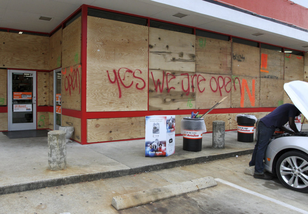
An auto parts store has wood paneling installed over the windows, Tuesday, Sept. 11, 2018, in New Bern, N.C., as a precaution against storm damage from Hurricane Florence. (Gray Whitley/Sun Journal via AP)
WILMINGTON, N.C. — Hurricane Florence, roaring across the Atlantic Ocean with 140 mph winds, is on track to crash into the southeast U.S. coast Friday and slow to a crawl, an ominous forecast that could deliver rainfall measured in feet rather than inches.
Tropical-storm-force winds are expected to arrive here in southeast North Carolina by Thursday morning. The National Hurricane Center said Tuesday that “life-threatening storm surge is now highly likely” along the North Carolina and South Carolina coasts, and government officials have issued evacuation orders covering more than 1.5 million residents there as well as in Virginia.
Forecasters said Tuesday afternoon that the eye of the massive storm would most likely make landfall during the middle of the day Friday on a stretch of the North Carolina coast between Wilmington and Jacksonville, home to the Marine Corps base at Camp Lejeune. The Hurricane Center warned that the storm was “getting better organized and increasing in size,” and predicted that, despite some modest weakening before landfall, it would strike the U.S. as a Category 3 hurricane with 120 mph sustained winds.
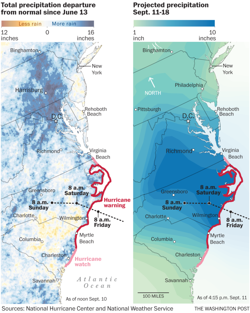 Coastal North Carolina could receive upward of 30 inches of rain near the storm’s landfall, which could combine with storm surge to exacerbate flooding for days, forecasters warn. They add that higher terrain in the Appalachian Mountains and the Piedmont – including much of Virginia – already is saturated from unusual summer rainfall and can’t soak up any more. Major flooding could affect areas as far from the projected landfall as Maryland, the District of Columbia, Pennsylvania and the Ohio River Valley.
“This storm presents us with multiple threats, multiple hazards,” Jeffrey Byard, an associate administrator with the Federal Emergency Management Agency, said in a teleconference Tuesday. He urged coastal residents to evacuate immediately if advised to do so by local officials: “Don’t wait until the last minute and see what happens.”
President Donald Trump, speaking to reporters after a briefing from FEMA administrator William “Brock” Long, encouraged people to flee the hurricane’s expected path: “I would say everybody should get out. . . . Once this thing hits, it’s going to be really, really bad along the coast.”
This is the first major challenge of the 2018 hurricane season for FEMA, which a government audit last week described as “overwhelmed” in 2017 when three major hurricanes hit the U.S. in the span of a few weeks. FEMA was caught short on supplies and qualified staffers when Hurricane Maria struck Puerto Rico, a storm that devastated and debilitated much of the island and has been blamed for nearly 3,000 deaths.
“We are absolutely and totally prepared,” Trump told reporters.
North Carolina Gov. Roy Cooper, D, on Tuesday announced the mandatory evacuation of the state’s popular and fragile barrier islands, including the Outer Banks, which often take the brunt of Atlantic storms.
“Even if you’ve ridden out storms before, this one is different,” Cooper said. “It’s an extremely dangerous, life-threatening, historic hurricane.”
Dare County officials warned that ocean overwash already was spilling onto low-lying roads and slowing evacuations there along the North Carolina coast. The storm has forced the closure of hundreds of schools throughout the region. Boeing and Volvo shut down their Charleston, South Carolina, factories, idling thousands who build jetliners and sedans.
In Virginia, officials said inland flooding could test the James River flood walls in Richmond, the state capital. The Navy commander of the Mid-Atlantic region authorized an emergency evacuation order for personnel who live in the low-lying area under mandatory evacuation, and corrections officials said they had evacuated a prison in that area. The mayor of the District of Columbia joined Maryland’s governor in declaring an emergency days before the rains have even begun.
The wave of disruptions spread Tuesday to the sporting world, when the University of North Carolina in Chapel Hill and North Carolina State University in Raleigh canceled college football games scheduled for Saturday.
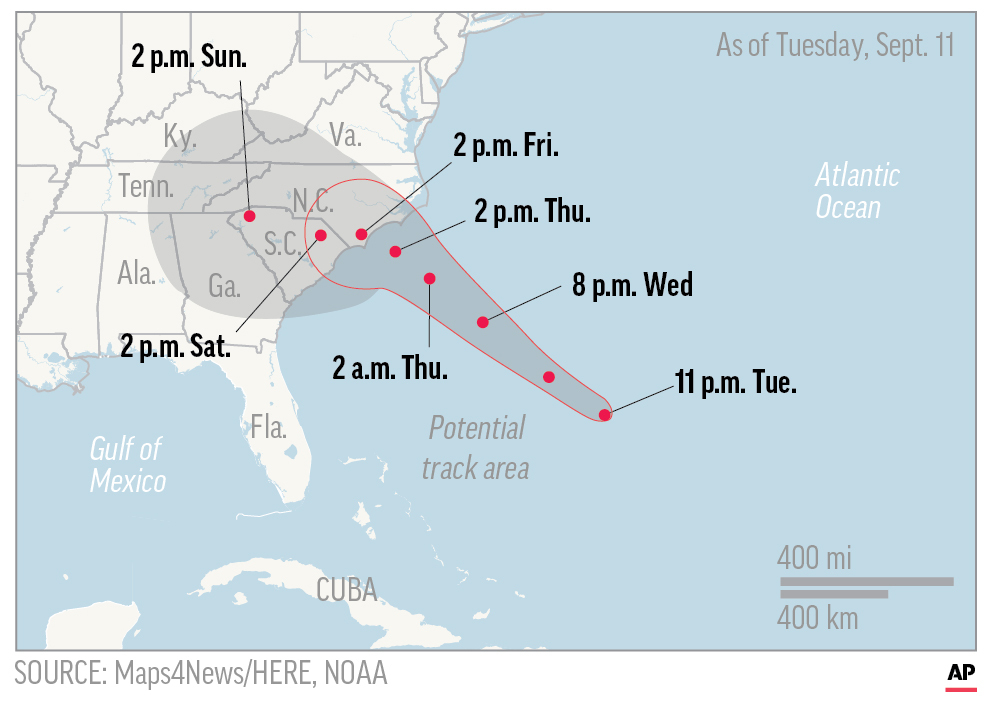
UPDATED WED 12 A.M. Map shows probable path of Hurricane Florence. ; 1c x 2 1/2 inches; 46.5 mm x 63 mm;
Forecasters had expected this to be a calm hurricane season – and it largely had been until a tropical depression off the African coast strengthened into a storm and then a full-blown hurricane named Florence. It, too, appeared unthreatening at first, because it was seen as likely to make a harmless clockwise circuit of open water in the Atlantic Ocean.
But Florence has defied historical patterns.
Hurricanes can pivot at the last minute, and there continues to be uncertainties about Florence continue. But the forecast track is ominously similar to what happened last year with Hurricane Harvey, which lost forward momentum as it moved out of the Gulf of Mexico and hit the Texas coast, parking itself over the Houston area and dropping up to 50 inches of rain, triggering historic flooding that continues to affect residents a year later.
The National Hurricane Center on Tuesday predicted that Florence would slow to just 3 to 5 mph once it hits land. The storm would quickly lose its violent windfield, and within 48 hours would be expected to be downgraded to a tropical depression. But as it stumbles toward the mountains, it would continue to dump massive amounts of rain – as much as 30 inches on the coast.
That would break North Carolina’s record for a tropical storm – 24 inches – set near Wilmington during Hurricane Floyd in 1999, said Greg Carbin, chief of forecast operations for the NOAA Prediction Center of the National Weather Service.
He said forecasters anticipate 15 to 20 inches will fall from Florence as it moves inland. In some places, so much rain already has fallen this summer that the water table is nearly at the surface.
“They can’t really take any more rain in Virginia,” Carbin said.
In Wilmington, the city was boarding up and shutting down Tuesday. At the Bridge Tender Marina, just three boats remained from the usual fleet of 70, said dock master Tripp Brice. The rest had sailed to safer ports to the south, he said – and the final three would soon be on their way as well.
Lines had formed at a Home Depot in Wilmington, where residents have been buying plywood to nail over their windows. In the parking lot, Donald Smith, 92, pushed a cart with two pieces of plywood. He said that if it were up to him, he’d do nothing at all to prepare for the storm.
His children, who live in New York, want him and his wife of 65 years, Peggy, to evacuate along with their three dogs and two cats. He won’t budge. He’d prefer to just “go with the flow,” he said.
Officials in New Hanover County, North Carolina, which includes Wilmington, urged residents to leave Tuesday or else be ready to remain self-sufficient for seven days without access to public utilities or commercial stores.
“If you can leave, you need to leave,” said county commission chairman Woody White.
The county and state combined to open a 500-bed shelter for Wilmington residents in Raleigh, and hired buses to take people there if they do not have other means of transportation. About 30 people lined up Tuesday afternoon under partly cloudy skies. Deputy county manager Avril Pinder said the number of evacuees was low “because it’s gorgeous outside.”
Delissa Pringle brought her five children to the scorching parking lot to catch the bus because the warnings hit home.
“I’ve been here all my life, and this is the worst I ever had to deal with,” she said, pausing in the bus doorway after her children boarded.
County workers reached out to medically fragile residents to ensure that they are safe or have a way to leave town, officials said. Nursing homes and other facilities for the elderly or infirm are responsible for making sure their residents are safe, they added.
White, who has been through five hurricanes in the area, said Florence has incited a level of alarm he’s never seen before.
“This is not the time to go out and party and have fun,” he said. “This is a time to look out for your family and pets.”
Traffic slowed to a crawl on the main interstate connecting Charleston and Columbia in South Carolina. In downtown Charleston, Sandra Mackey was among 100 people gathered Tuesday morning in a former Piggly Wiggly supermarket parking lot to take advantage of free sand and sandbags the city is providing. She knows what a hurricane can do because she survived Hugo in 1989. It was harrowing, with 140 mph winds.
“I swore, ‘never again’,” she said.
But she’s staying this time, she said, because her husband had a stroke and she doesn’t want him to have to endure an evacuation. A central feature of her plan: She believes the storm will strike somewhere other than Charleston.
– – –
Samenow and Achenbach reported from Washington. The Washington Post’s Ann Gerhart in Washington and Doug Pardue in Charleston, South Carolina, contributed to this report.
—
Video Embed Code
Video: Hurricane Florence is forecasted to be a strong Category 4 storm by the time it makes landfall Thursday evening. Capital Weather Gang’s Angela Fritz explains what that could mean for the Southeast and Mid-Atlantic regions.(Joyce Koh/The Washington Post)
Embed code: <iframe src=”https://www.washingtonpost.com/video/c/embed/8da311ea-b51f-11e8-ae4f-2c1439c96d79?ptvads=block&playthrough=false” width=”480″ height=”290″ frameborder=”0″ webkitallowfullscreen mozallowfullscreen allowfullscreen></iframe>
Video: From the Outer Banks to Wilmington to Raleigh, people in North Carolina are boarding up or moving out as the arrival of Hurricane Florence looms.(Zoeann Murphy,Jorge Ribas,Whitney Shefte,Lee Powell/The Washington Post)
Embed code: <iframe src=”https://www.washingtonpost.com/video/c/embed/ca674bec-b622-11e8-ae4f-2c1439c96d79?ptvads=block&playthrough=false” width=”480″ height=”290″ frameborder=”0″ webkitallowfullscreen mozallowfullscreen allowfullscreen></iframe>
Send questions/comments to the editors.

Success. Please wait for the page to reload. If the page does not reload within 5 seconds, please refresh the page.
Enter your email and password to access comments.
Hi, to comment on stories you must . This profile is in addition to your subscription and website login.
Already have a commenting profile? .
Invalid username/password.
Please check your email to confirm and complete your registration.
Only subscribers are eligible to post comments. Please subscribe or login first for digital access. Here’s why.
Use the form below to reset your password. When you've submitted your account email, we will send an email with a reset code.