


Editor’s Note: This story is part of a special, two-part report is part of a continuing series on poverty in Maine, and the strangling affect poverty has on our communities. We look at how vital broadband accessibility is for our schools, our businesses and our health. The work is being done in cooperation with the Investigative Editing Corps.
Suppose you need to find your way from Kittery to a sweet little camp hidden away in the woods of Piscataquis County, maybe beside a pretty lake with Mount Katahdin looming in the distance.
But your car’s GPS has failed and your cellphone can’t pick up a signal — hardly unusual in Maine — so you have to navigate on instinct and luck.
Hopelessly lost in a patchwork of local roads, you finally find someone to ask for directions. And, of course, an old joke comes true and you’re informed that “you can’t get there from here.”
At that moment, the necessity of a good map to help you get where you want to go could not be more obvious.
It’s really no different for those trying to find a path forward for better broadband in Maine.
Government — Maine and federal — knows where it wants to go: ensuring most everybody has access to reliable, affordable high-speed internet. But it lacks maps that show how to get there.
In the latest federal pandemic aid package, Congress allocated $20 billion to spread around the country — $130 million of it for Maine — to bring broadband to unserved areas.
But neither officials in Maine nor the federal government can accurately identify who needs service because they don’t have precise data.
The maps available now, Gov. Janet Mills said, are “woefully, woefully inadequate.”
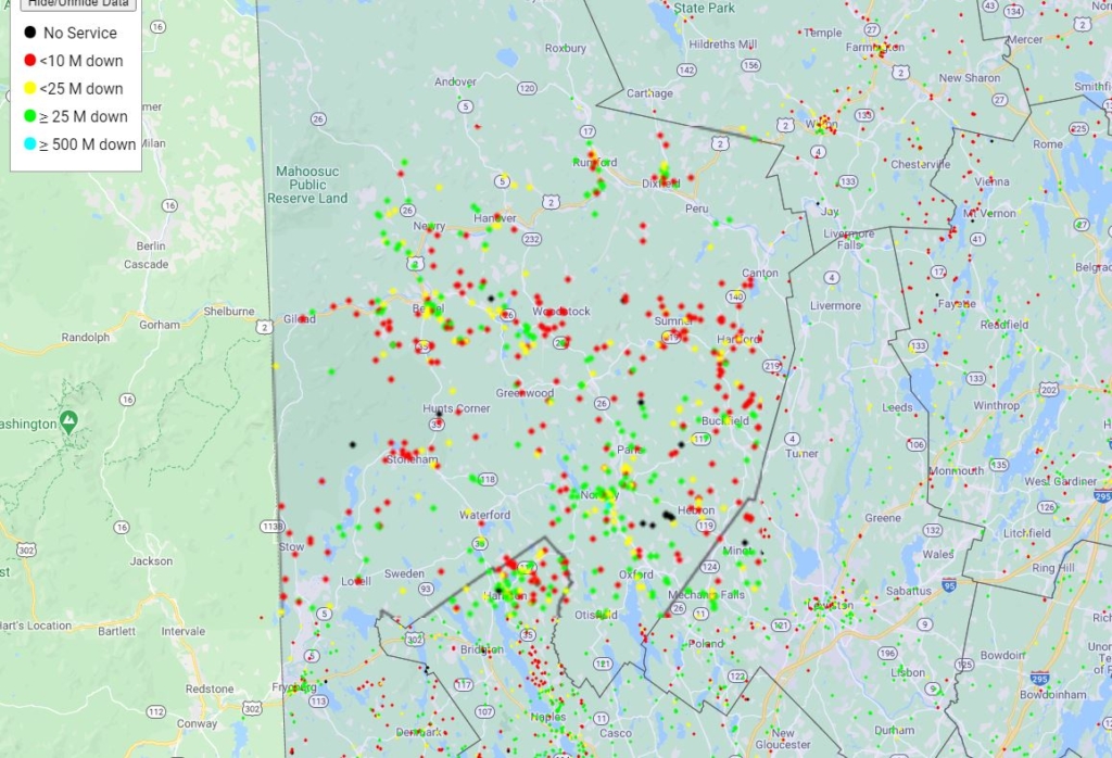
In this view of the Maine Broadband Coalition’s map, focused on Androscoggin, Franklin and Oxford counties, the red dots indicate places with slow internet, the green ones correlate to fast connections and yellow ones are middling. A few black dots mark spots with no service. Maine Broadband Coalition
It’s a national problem, skewing the distribution of federal cash that’s supposed to help unserved and underserved areas connect to broadband and making expanding existing systems difficult to plan.
Microsoft’s chief data analytics officer, John Kahan, said two years ago that “getting these numbers right is vitally important.”
“This data is used by federal, state and local agencies to decide where to target public funds dedicated to closing this broadband gap,” he wrote on the company’s website.
“That means millions of Americans already lacking access to broadband have been made invisible,” Kahan said.
The year-long pandemic has focused attention on the necessity of lending a hand to those who lack broadband in an era that increasingly requires internet access for school, work and more.
Though the federal government is taking steps to improve its maps, states like Maine are rushing to fill the gap in the meantime by gathering more information from a wide array of resources, including internet providers and private firms that have scooped up an array of data not publicly available.
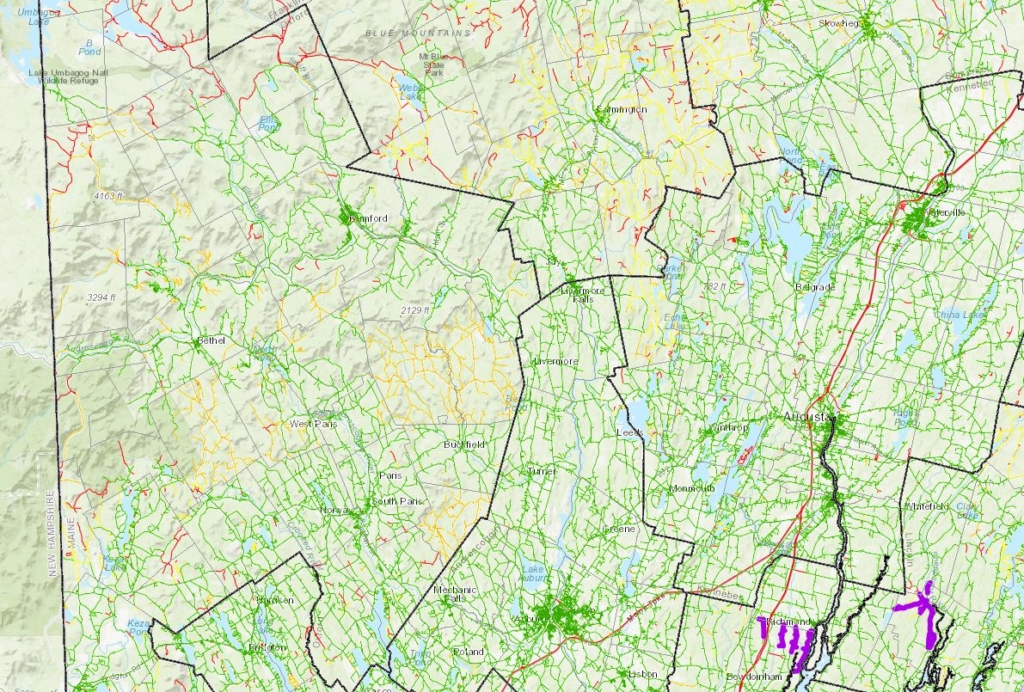
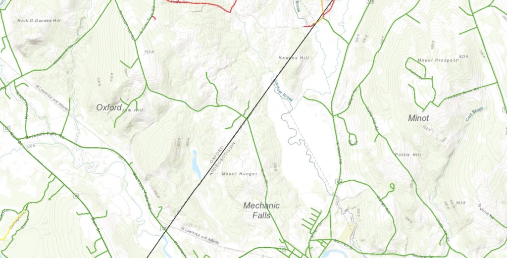
The ConnectMaine Authority used data from the federal government and confidential information from internet providers in Maine to create a map that shows, roughly, which roads have broadband connections running alongside the pavement. It doesn’t mean everybody who lives there can actually access broadband. This map shows much of Androscoggin, Oxford and Franklin counties.
The information provided by companies, which helps guide state policy, is considered proprietary and, in keeping with contracts signed by the state, kept confidential. But even with that data, Maine still can’t say with certainty who has access to broadband and who doesn’t.
To get the Pine Tree State fully online, “we need to have some basic information” that simply isn’t accessible, said Peggy Schaffer, executive director of ConnectMaine, the agency spearheading the state’s initiative to bring Maine out of the webless wilderness.
WHY EXISTING MAPS AREN’T ENOUGH
Most of what’s known about broadband coverage comes from maps prepared by the Federal Communications Commission, which has compiled data gathered from internet providers.
Providers fill in forms that require them to figure out the 15-digit code for each census block they service, even if the service only goes to a single home. The blocks, carved out to help census takers count America’s population, range from city neighborhoods to large swaths of rural land, including an 8,500-square-mile parcel in Alaska.
If even one household in a particular census block has broadband, the FCC counts the whole area as entirely served.
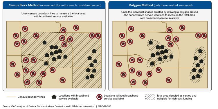
These maps depict two different ways of determining if an area has broadband access. On the left, using the existing Federal Communication Commission map system, most of the homes are considered “served” even though many in the shaded areas do not have access. The new maps will use the system on the right, which creates boundary shapes from polygons, presenting a far more accurate picture of which homes have broadband access and which do not. Government Accountability Office
The resulting maps are nowhere near accurate, providing a false sense of coverage in places whose residents in reality have no way to access broadband.
The acting chair of the Federal Communications Commission, Jessica Rosenworcel, said last year that “there are communities in this country with blazing fast gigabit speeds and areas where buffering means suffering and still others where there is no service to be found at all.”
She called it “the sad truth” that the FCC “does not know with precision where these areas are.”
“We don’t know where broadband is and is not across this country,” Rosenworcel said in a case she helped decide last year. “If you think that’s crazy, you’re right.”
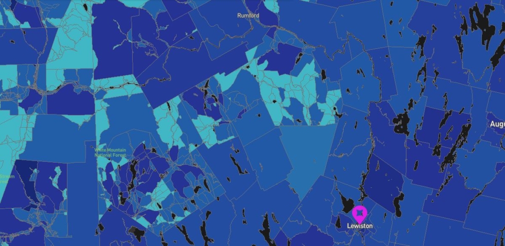
The Federal Communications Commission map of broadband in Androscoggin, Oxford and Franklin counties shows splashes of blue that mean little. Zoom in on a particular census block, though, and it will provide information about providers that say they offer internet service to residents, though many of them can’t actually connect.
TRYING TO FIX THE MAPS
With COVID-19 pushing people to work and study remotely, the dearth of available access to the internet in many parts of the country, and throughout much of rural Maine, have become a hot political issue — but not a new one.
The FCC first began trying to map America’s broadband after it received money in the 2009 economic stimulus package promoted by President Barack Obama to try to lift the nation out of a recession. By 2011, the agency had put together the first version of its nationwide map, something it has regularly improved but which has always lacked the detail needed.
Even before the pandemic, Congress recognized the problem, nudging the FCC for improvements before last spring with a measure that its chief sponsor, U.S. Sen. Roger Wicker, a Mississippi Republican, summarized as telling the FCC to “go back. Get the maps right. Show us where we have coverage and where we do not have coverage.”
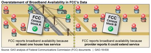
Using census blocks to define areas, the Federal Communications Commission considers the block on the left as served with broadband despite some houses not having access. On the right is a block with no service, which the agency considers to be in need of help. General Accounting Office
Lawmakers subsequently allocated $98 million in December to address the mapping problem.
“It is not an exaggeration to say this FCC’s terrible broadband data is its Achilles heel,” said U.S. Rep. Frank Pallone, the New Jersey Democrat who chairs the House Energy and Commerce Committee.
To comply with the new law, the FCC must create a new national map that shows where broadband exists and what areas remain unserved. Jean Kiddoo, who heads an FCC task force on the issue, told the Associated Press it will be at least next year before improved maps are ready.
Peggy Schaffer, ConnectMaine executive director Submitted photo
Already behind the technological curve, Maine doesn’t want to wait any longer for the FCC.
Schaffer said Maine has already sought to supplement the FCC maps by asking internet providers in the Pine Tree State to share the data they have on who has service and who doesn’t.
The companies, which range from big corporations to mom-and-pop operations, are “very, very protective of this data,” she said, and don’t have any particular reason to hand it over. But many have done so after getting Maine to sign nondisclosure agreements that keep the particulars secret.
Schaffer said if competitors could see all the data, they could find weak spots in competitors’ systems they might want to challenge — and none of the firms is interested in lending a hand to anyone that might take them on.
In any case, ConnectMaine has used the providers data to supplement the FCC maps and create its own map that makes it somewhat clearer which roads are wired for broadband and which ones are not. But it’s a far cry from thorough.
“We need good data,” Schaffer said, but it simply doesn’t exist, a problem she’s highlighted nationally, putting Maine among the states most active in trying to fix the maps.
WHAT’S HAPPENING TO IMPROVE MAINE’S MAPS
The Maine Broadband Coalition’s solution is to create a new map based on data provided by residents across the state who choose to do speed tests to see how quick their internet is from wherever they are.
People who go to the site are asked to click on a “Run Speed Test” link that asks them to put in their address. It has an option at that point to say there is no internet at that address, which can be picked by someone logging on from someplace other than an unserved home. If they do have service, the site proceeds to figure out how fast the connection is.
This map was produced by the state using data provided by the FCC and by internet providers in Maine. It shows in rough terms which roads are wired for broadband service and which ones are not. Having a wire by the road does not mean that a homeowner can affordably connect to the internet, depending on how far the home is from the road. ConnectMaine
Not surprisingly, it shows that the fastest connections are in Portland and along the coast south to Kittery, but Lewiston and Bangor are among the other areas that don’t fare badly. Western and northern Maine lag far behind. Many areas between cities have paltry or no broadband.
Mike Wilson, senior program director of the Northern Forest Center, said the coalition takes the data in real time and plots it on a map in an effort to see the reality of what’s out there. The more people who try it, he said, the more accurate the map will be.
The coalition’s map, which relies on people to do a speed test, shows specific points, though, and doesn’t shed light on what’s between them.
Understanding those gaps remains crucial.
To help fill them in with granular detail, Gov. Janet Mills is seeking $1.8 million from legislators that would provide a further boost for mapping by hiring consultants that haul in more data from an array of public and private sources.
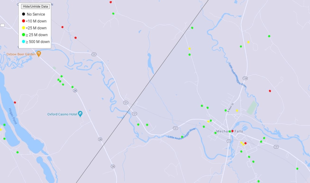
This map shows the results of speed tests voluntarily performed by people living between Mechanic Falls and Oxford during the past few months. Green dots show acceptable broadband levels while yellow, red and black are all below the federal government’s low standard for internet speed. A variety of factors can influence the speed. Maine Broadband Coalition
Heather Johnson, the state’s commissioner of economic and community development, said the allocation would be used in part to tap into data such as the speed tests that would show much more than existing maps.
“It would help us determine where the gaps are,” Johnson said.
The Minnesota-based GEO Partners, the consultant likely to work with the state if funding is endorsed, has already helped communities in western Maine assess the cost of creating a broadband system in 26 rural towns and unorganized territories that would rely on fiber and wireless to reach residents.
With better maps, officials said, it’s possible to figure more efficient ways to build out the fiber, cable and cellular infrastructure that would boost the availability of fast internet.
Some of it may be 5G phone technology that cuts out some of the wiring costs. But even 5G requires fiber optic lines that don’t yet exist.
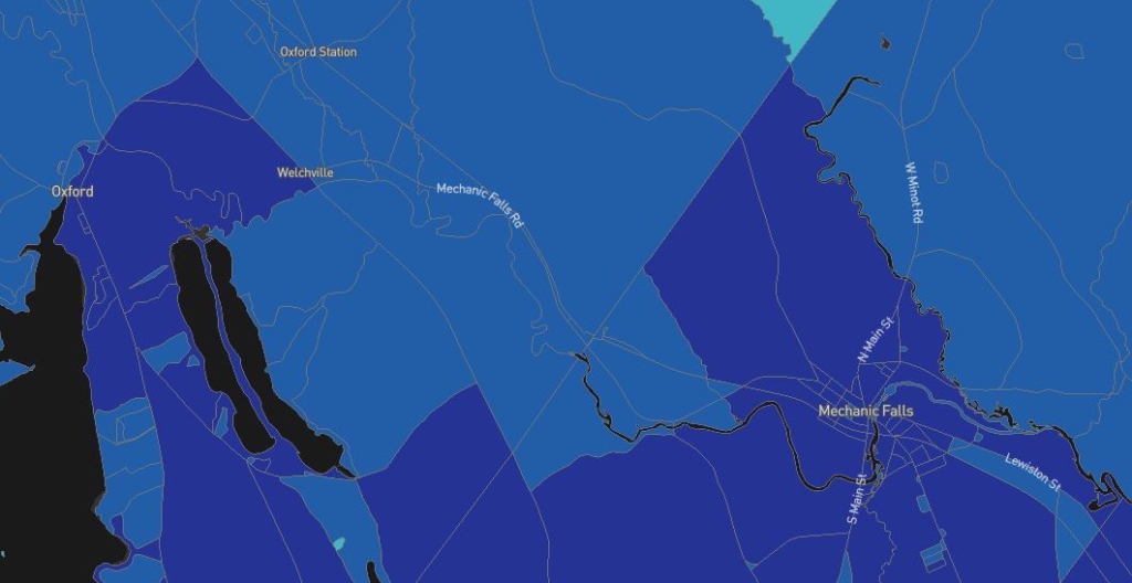
This shows a portion of the Federal Communications Commission broadband map between Mechanic Falls and Oxford. The darker the color, the more providers exist within that census block. But there is no way to tell how many people can get high-speed internet or where they actually live. FCC
Johnson said many people don’t realize wireless systems, basically cellular plans, rely on fiber connections between their towers. Fiber optic lines reaching into remote areas are still needed, she said.
“Fiber density is the key to success long-term,” she said.
Johnson said that with good maps, officials can determine where bottlenecks exist — and where unnoticed opportunities may be available.
GOOD MAPS MAY HELP BRING DOLLARS TO MAINE
Schaffer said that many millions of dollars in federal broadband aid are doled out in large part based on the lousy maps the FCC has — maps that make many Maine communities “not eligible for a dime” because they mistakenly make it appear the area has service.
Schaffer called it “a waste of resources” to focus the money only on places the FCC sees as lacking broadband, where there may be few people, rather than using the money more efficiently.
With solid maps, Johnson said, rolling out new systems becomes “a very solvable problem.”
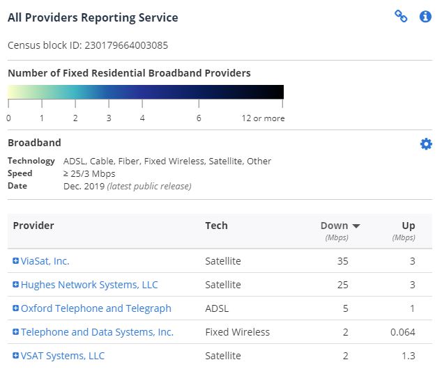
People living in the center census block between Mechanic Falls and Oxford, according to the Federal Communications Commission, have five possible internet providers. Only one of them offers service that would qualify as broadband under current rules. None of them come close to the level the state would like to see available for internet capability. FCC
By creating its own maps that present a much more accurate picture of reality, Schaffer said, the state will empower efforts to get the infrastructure Mainers need “and take charge of their own future.”
Poor data should not be allowed to “hold back an entire society.”
“It’s not an easy issue,” Mills said, but with maps, willpower and funding, the governor said Maine’s broadband infrastructure can make big strides in the next few years.
Send questions/comments to the editors.

Success. Please wait for the page to reload. If the page does not reload within 5 seconds, please refresh the page.
Enter your email and password to access comments.
Hi, to comment on stories you must . This profile is in addition to your subscription and website login.
Already have a commenting profile? .
Invalid username/password.
Please check your email to confirm and complete your registration.
Only subscribers are eligible to post comments. Please subscribe or login first for digital access. Here’s why.
Use the form below to reset your password. When you've submitted your account email, we will send an email with a reset code.