

WGME graphic
UPDATED 2 P.M.: Auburn has declared a parking pan from 9 a.m. to 9 p.m. Friday. Check the city’s website for parking information.
Lewiston has declared a parking ban from 8 a.m. to 5 p.m. Friday. Check www.lewistonmaine.gov/winter for more information.
UPDATED 12:58 P.M.: Enjoy the sunshine on Thursday ahead of snow for Friday. Thursday’s temperatures will warm into the mid to upper 30s by the afternoon with mostly sunny skies. Clouds increase Thursday night with snow arriving for Friday morning.
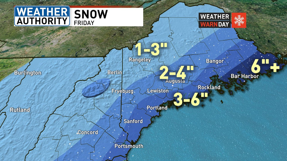
FRIDAY MORNING: Expect snow to develop between 4 a.m. and 6 a.m. and last through the morning commute and into the afternoon. The heaviest snow looks to be during the morning. Travel may become difficult with moderate to heavy snow.
FRIDAY AFTERNOON/EVENING: The snow will start to move out during the late afternoon and into the evening. We’re looking at several inches of snow with this storm, and all snow with no mixing expected.
HOW MUCH: The most snow will be towards the coast where 3-6 inches is expected, portions of Downeast Maine could see over a half a foot. We’ll have lighter amounts through the hills and mountains.
WEEKEND OUTLOOK: The sunshine returns Saturday but it will be cool with highs just in the 20s. Sunday will be a little warmer with highs in the 30s, but it will not be as nice with the chance for rain or snow showers at the coast and snow/ a wintry mix inland.
LOOKING AHEAD: Much colder air moves in for the start of next week. Temperatures will drop through the day on Monday despite mostly sunny skies with overnight lows in the single digits or below zero. Tuesday looks like the coldest day of the season so far with highs just in the single digits, and overnight lows dropping below zero. Some more snow showers could move in mid-week.
Copy the Story LinkSend questions/comments to the editors.

Success. Please wait for the page to reload. If the page does not reload within 5 seconds, please refresh the page.
Enter your email and password to access comments.
Hi, to comment on stories you must . This profile is in addition to your subscription and website login.
Already have a commenting profile? .
Invalid username/password.
Please check your email to confirm and complete your registration.
Only subscribers are eligible to post comments. Please subscribe or login first for digital access. Here’s why.
Use the form below to reset your password. When you've submitted your account email, we will send an email with a reset code.