


UPTON — For nearly 50 years, Gary and Rachel Fysh spent their late summer days cruising and fishing Lake Umbagog, the last in the Rangeley region’s chain of lakes.
But on the first day of August last year, they pulled their boat from the lake and stored it in their driveway, mourning the premature end to one of their favorite summertime pastimes.
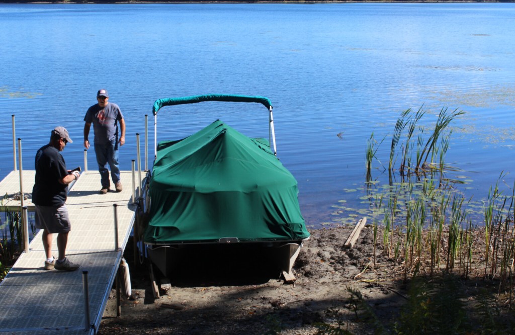
It wouldn’t be long until the water level fell so low that boats and docks were left sitting in mud.
“None of us have ever seen anything like this,” Gary Fysh said.
Last summer, western Maine was in the midst of a severe drought, the worst in at least two decades, which caused some lakes and rivers to hit record lows and wells to run dry.
Even now, much of the Rangeley lakes region remains in severe and moderate drought conditions, according to the U.S. Drought Monitor.
According to that monitor, which is a project of the National Oceanic and Atmospheric Administration, a drought of similar severity hit the region from 2001-03.
Yet, Gary and Rachel Fysh are among a group of locals who believe poor water management, not the drought, is to blame for what they say was the lowest summer water level in decades. Two of the three major inflows to Lake Umbagog, as well as the only outflow, are controlled by dams acquired by Brookfield Renewable a decade ago.
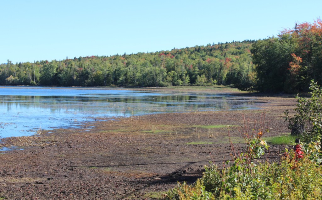
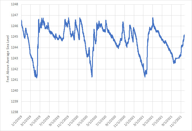
At its most extreme on Sept. 15, 2021, the surface of the water was 4½ feet lower than it would be had the lake been full, according to Brookfield’s data.
For a lake with an average depth of 15 feet, it’s a significant drop.
“We’ve been here all our lives,” Rachel Fysh said. “Literally, the first year (Brookfield) came in, we noticed, and we called and complained, because we knew. It was so minute, but we knew it wasn’t right, something was going wrong … and it got worse, and worse, and worse since then.”
Rachel and Gary Fysh are members of The Friends of Lake Umbagog, an unincorporated group of Maine and New Hampshire residents recently formed to advocate for higher water levels on the lake. They argue low water levels not only hurt locals, some who own camps only accessible by water, but also the ecology and economy of the region.
But below the surface of Brookfield’s water management is a complex interplay of license requirements and competing interests.
Much of the water which flows into Lake Umbagog comes from lakes with residents just as keen to protect their water levels. Downstream from Lake Umbagog are mills and wastewater treatment facilities which rely on consistent, adequate water flow.
It’s a problem with no easy solution.
But if there was ever a time for Umbagog locals to file complaints and press for changes, it’s now. The license agreement for the Errol hydroelectric dam, which controls the flow of water from Lake Umbagog into the Androscoggin River, expires in 2023 and Brookfield recently filed an application to relicense the project.
Until the final license is issued, residents have a narrow window to attempt to influence Lake Umbagog’s water management in the coming years. It’s an opportunity that will not be seen again until at least 2053.
‘THE LOWEST I’VE EVER SEEN IT’
Virtually all of Lake Umbagog’s shoreline is conserved by the Umbagog National Wildlife Refuge, providing near pristine nesting habitat for loons and other waterfowl.
For nearly two months each year, Brookfield is required to maintain specific water levels on Lake Umbagog to protect loon nests from flooding.
Although the water level was already half a foot lower than usual in June last year, it was reduced by an additional half-foot to protect nests from flooding as required by the protection plan, said Umbagog Wildlife Refuge manager Paul Casey.
In his professional experience, he said Brookfield has done a better job following the water level management plan during nesting season than the previous dam owners.
The water level on Lake Umbagog, already low when the summer began, continued dropping throughout the summer. More water was leaving the lake than flowing in.
“The region was challenged early on with below-average snowpack and a lack of spring rain, contributing to the low reservoir levels. These conditions worsened as drought conditions continued throughout the year,” Julie Pelletier, director of ESG, sustainability, and public affairs at Brookfield, wrote in a statement.
Many Umbagog locals are not convinced by this explanation.
James Philbrick of Candia, New Hampshire, wrote to the Federal Energy Regulatory Commission last fall acknowledging the climate conditions, but asserted that he had never seen such a dramatic drop in water level in the 35 years he’s owned a camp on the lake.
“(We) have experienced a wide range of weather patterns,” he wrote. “At no time has the water level approached this low level in August.
Gary and Rachel Fysh were in agreement. They believe excessive draws during the winter months contributed to the lower-than-normal water levels in the spring.
In the winter of 2020, the couple went ice fishing on Umbagog in a spot they’ve used for decades. For the first time ever, their fishing lines hit dirt.
“We start our spring empty, which we never did in the past, because they drain down to nothing under the ice where no one can see,” Rachel Fysh said.

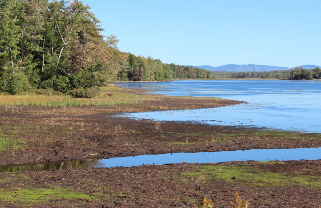
At its most extreme on Sept. 15, 2021, the surface of Lake Umbagog was 4 1/2 feet lower than it would ordinarily be had the lake been full, exposing bare, muddy shores. Submitted photo
In the last three years, Umbagog’s water level was drawn down to a low of 6 feet below full in early spring, then quickly refilled over two to four weeks, according to Brookfield’s data.
Generally, water levels are reduced during winter to create water storage capacity, helping to manage flooding conditions from snowmelt and runoff.
Both Philbrick and Gary Fysh know dams; they were employees of Public Service of New Hampshire power generation for more than three decades. Fysh said he was a lineman and supervisor working on hydroelectric dams in Berlin for 38 years.
Casey, who lives in Upton, said he heard that other lakes in the region were also severely low last summer.
“I heard from fishermen that they’re like ‘oh yeah we can’t launch up in Aziscohos because the water’s 8 feet down and the ramp doesn’t get down to the water,’ I heard fishermen from Rangeley Lakes saying ‘oh yeah the water’s down 2 feet.’”
However, with a shallow lake like Umbagog, he said a drop of even a few feet can make the lake difficult, if not impossible, to navigate by boat.
“From my perspective, again, this was a unique year, and it was the lowest I’ve ever seen it, but I’m sure it’s just a fluke,” Casey said. “And next year, we’re going to be able to manage it higher.
“But I can understand where people get upset, because when you’re waterfront and you can’t get down to your boat and get out on the lake because you’re sitting on dry ground, that’s not very pleasant.”
COMPETING INTERESTS
At the top of the chain of lakes sits Rangeley, followed by Mooselookmeguntic, Upper Richardson, Lower Richardson, then Umbagog. Aziscohos Lake, an impoundment to the north, flows into Umbagog by way of the Magalloway River.
Water flows between these lakes are regulated by several Brookfield-owned dams, which each have its own terms and conditions for operation, some stipulating minimum water flows and lake levels.
Many current water management restrictions and requirements for these dams were established in a 1998 agreement which didn’t take effect until December of 2002.
In 2021, Brookfield operated the Errol Dam in compliance with all of the terms and conditions of these documents, wrote Pelletier.
Still, “The Androscoggin storage system is expected to provide minimum flows, but this target was rarely met during 2021 in part because water was held back at Errol,” she wrote. “Similarly, Brookfield’s hydroelectric generation from the station was significantly reduced throughout 2021.”
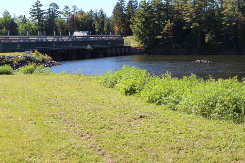
The Errol Dam’s license, issued in 1983, expires in 2023. Lake Umbagog locals are requesting changes to the license agreement which would improve the lake’s water levels. Submitted photo
In a January letter representing members of The Friends of Lake Umbagog, Freda Hawkins of Manchester, New Hampshire, listed five requests directed at FERC, which is currently considering Brookfield’s final license application for the Errol Dam.
Among these requests, she asked the agency to remove the minimum water flow requirement for the Androscoggin River and include a minimum water level for Umbagog Lake at least 2 feet below its full water level during the summer months.
She argued that the minimum flow, which has remained unchanged since 1907, was put into place to ensure adequate water flow to power paper mills downstream.
The closure of the Berlin mill in 2008 means Berlin no longer needs the minimum water flow.
She believes that Brookfield, which owns 19 of the 21 hydroelectric dams on the Androscoggin River by her count, serves to benefit from prioritizing river flows over lake levels.
However, wastewater treatment facilities and paper mills in Rumford and Berlin could be negatively impacted by reduced water flows on the Androscoggin, in addition to recreational activities.
Editors Note: This article was updated to include information on why reservoir water levels are drawn down during the winter.
Send questions/comments to the editors.

Comments are no longer available on this story