


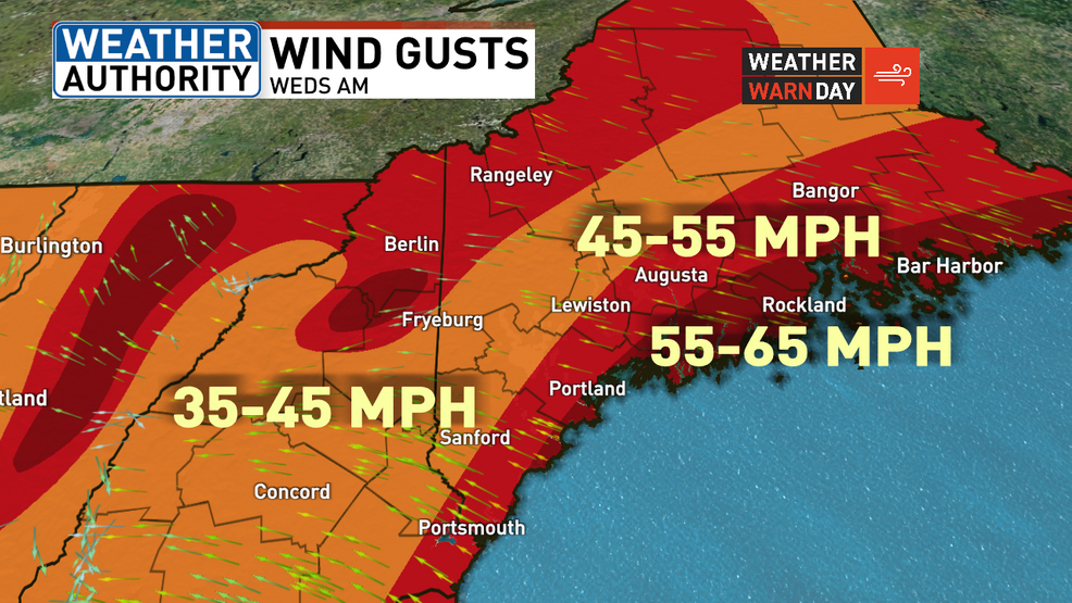
Peak wind gusts through 9 a.m. Wednesday will be near 65 mph along the coast. WGME graphic
Mainers readied for a storm of a different bluster Tuesday evening as forecasters promised heavy, wet snow, hazardous winds and potential flooding into Wednesday, a stark change from the nearly 20 inches of fluffy white powder some areas in Maine experienced during Sunday’s snowstorm.
State and county emergency management agencies, utility companies, local public works, police and fire departments requested vigilance from Mainers first for heavy and wet snow, considerable winds and for torrential rain and flooding.
National Weather Service issued a flood watch beginning at 10 p.m. Tuesday until 4 p.m. Wednesday and a winter storm warning from 5 p.m. Tuesday to 7 a.m. Wednesday. Parts of Maine can expect anywhere from a dusting of snow to 13 inches, half an inch to 3 inches of rain, inland winds as high as 45mph and higher gusts toward the coast.
Pine Tree Weather’s Mike Haggett said like many forecasters, he’s been worried about this storm for over a week. Oxford County, south of the mountains and into the foothills, Haggett gave for example, won’t have the kinds of winds the coast may see, but the heavy wet snow, likely 2 to 3 inches per hour all through the night, will complicate things.
“You don’t have to have a whole lot of wind to have a whole lot of problems,” Haggett said. “I can virtually see 6 to 12 to maybe 14 inches of snow sticking to everything and then just enough wind to bring tree branches down and take out power lines. It isn’t going to take much wind to play a role and make a mess out of things.”
The Lewiston-Auburn area can expect about 4 to 8 inches of snow by 4 a.m. Wednesday when it turns to rain, according to the National Weather Service forecast. Throughout the night, temperatures were expected to rise to about 38 degrees and 15-25 mph winds were expected to have occasional 45 mph gusts. On Wednesday, the area could expect highs of 47 degrees, southeast winds giving way to southwest winds of 15-20 mph and gusts up to 50 mph. Rain accumulations will be half-an-inch to three quarters of an inch.
Parts of the western Maine and northern New Hampshire mountains can expect 9 to 13 inches of heavy wet snow, 8 to 12 inches in the Farmington to Waterville stretch and 7 to 11 inches in the Rangeley area.
Gov. Janet Mills delayed the opening of state offices until noon Wednesday and advised motorists to drive carefully.
Auburn, Lewiston and Lisbon all instituted parking bans; Lisbon’s from 7 p.m. Tuesday to 8 a.m. Wednesday, Auburn’s from 8 p.m. Tuesday to 11 a.m. Wednesday, and Lewiston’s from 9 p.m. Tuesday to 7 a.m. Wednesday.
Androscoggin County Emergency Management Director Angela Molino said her office is constantly reviewing information from National Weather Service for what they call a “multifaceted event.”
“The precipitation that we’re forecast to get — combined with frozen ground, saturated soils and possibly snow clogged storm drains — will lead to higher-than-normal runoff,” Molino said. “But I’m confident that our public safety public works are poised and ready to go as always.”
Central Maine Power spokesman Jon Breed said crews are still poised to respond to power outages, but the wind will be the determining factor for how quickly outages can be handled. And there will be outages based on what the forecasts show, he said.
“We don’t anticipate this to be at all like the storm prior to Christmas, though based on the wind speed composition and the snow composition, we could some damage,” Breed said, adding that crews are constantly monitoring where the rain/snow line will fall. “That is where we would anticipate that the heaviest, wettest snow to be and that is what can be most damaging to trees.”
Breed said wind direction will also play a significant role in downed trees.
“When sudden winds hit their weaker side sometimes that can increase the amount of damage we see as well,” Breed said. “But we’ll be ready for this one to come in.”
Comments are not available on this story.
Send questions/comments to the editors.
