


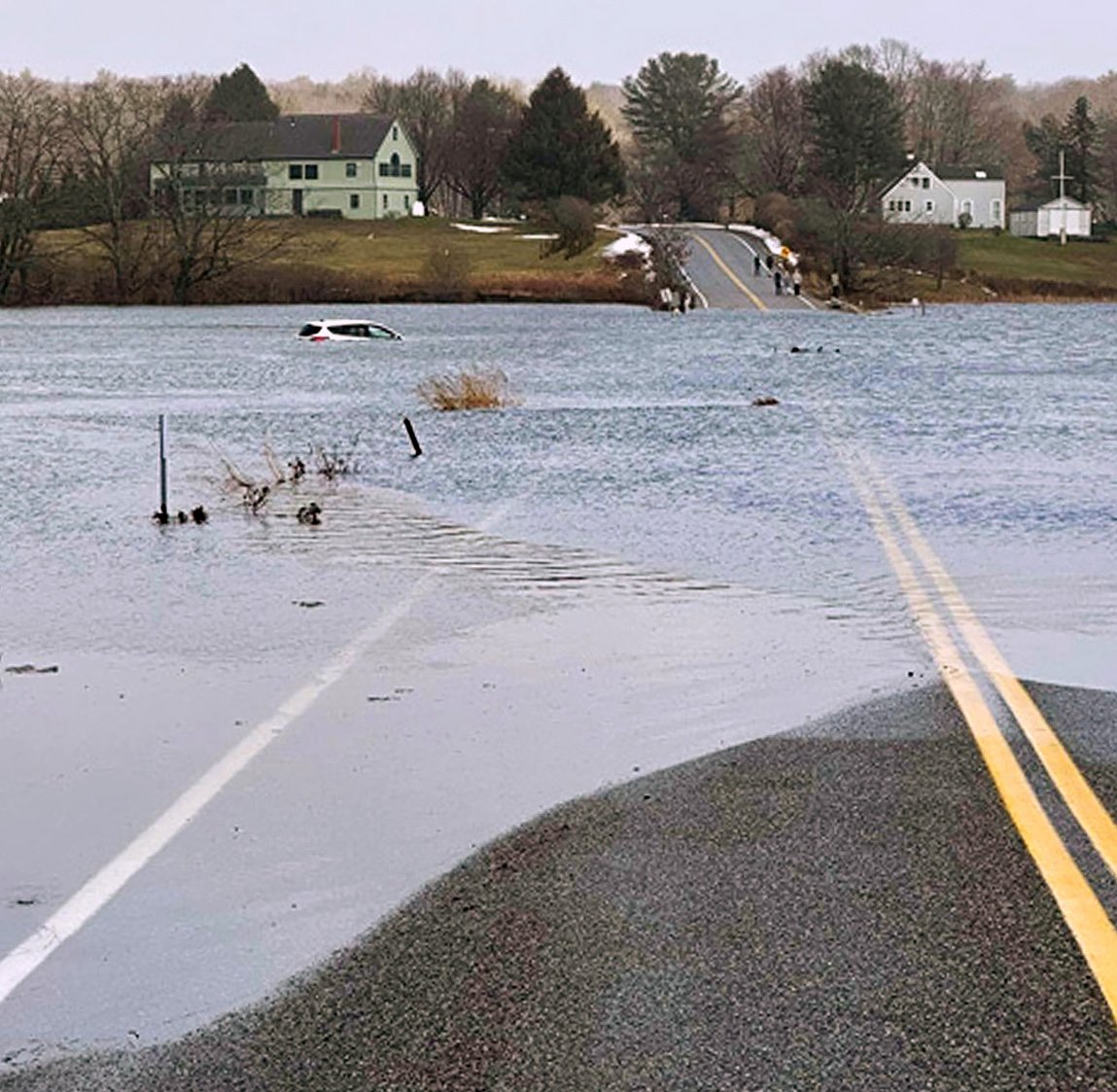
High tide combined with a storm surge raised the Spurwink River so high on Jan. 10 that it washed a car off Sawyer Road and into the marsh. The motorists had to be rescued. Courtesy of Town of Scarborough
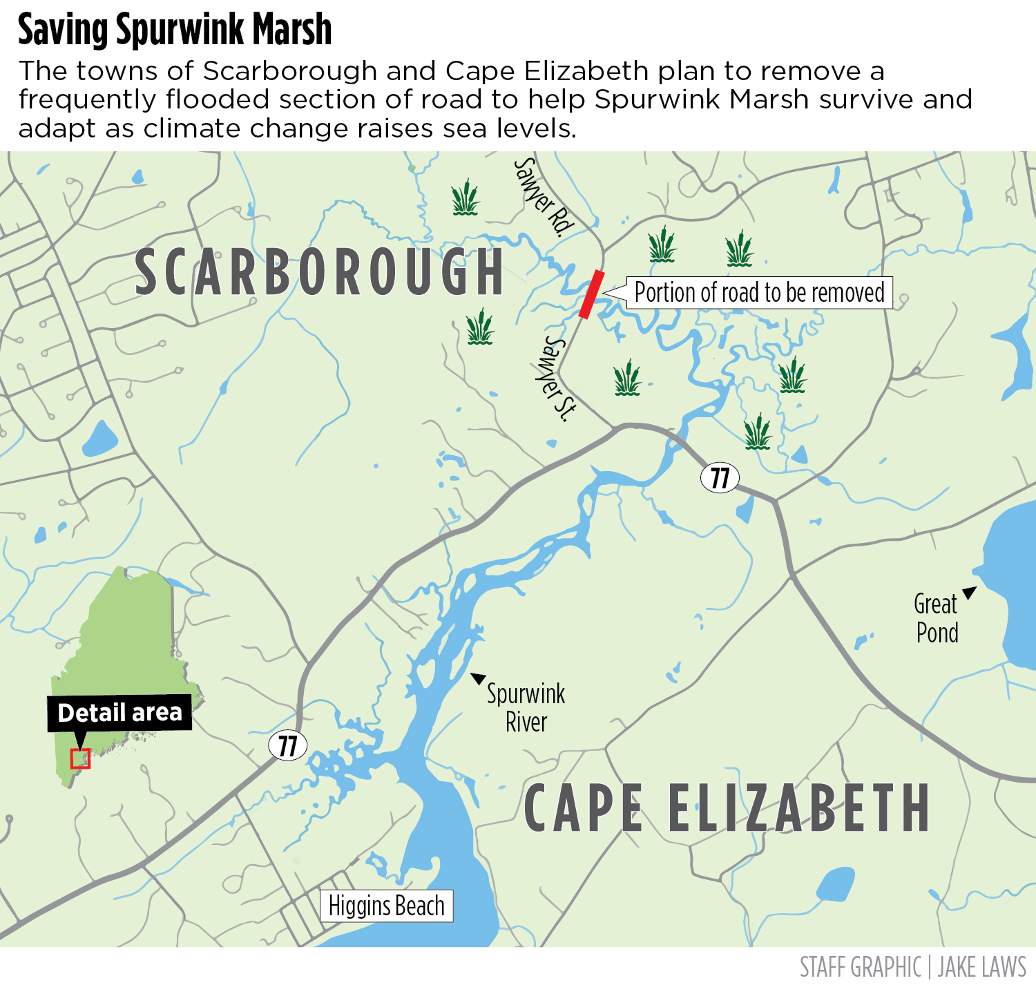
Cape Elizabeth and Scarborough are planning to remove a section of a flood-prone road that is blocking the inland migration of a federally protected coastal marsh in what project managers say may be Maine’s first case of “managed retreat” in the face of climate change and rising sea levels.
The 1,400 feet of road through Spurwink Marsh – a 487-acre salt marsh that is home to state-endangered salt marsh sparrows and New England cottontails – floods during the highest tides each month. During the storm on Jan. 10 when a storm surge coincided with high tide, rising waters washed a car off the road into the marsh and forced an emergency rescue.
“The road faces so many challenges – a failing culvert, an impaired marsh, king-tide flooding – yet it only has 1,200 daily trips,” Cape Elizabeth Town Planner Maureen O’Meara said. “After a while, I had to ask myself: ‘Are we sure we even want to fix it? Is this where we want to spend our limited resources?’ ”
That question – to rebuild or retreat – is being asked in communities up and down the state’s rocky coast, from the southern Maine salt marshes to Midcoast boatyards to Acadia National Park, as the state comes to grips with the inevitability of rising seas and the increasing frequency and ferocity of extreme weather.
Many coastal communities are rushing to rebuild after the recent winter storms, but O’Meara and other officials are asking if that’s always the right choice. Sometimes, it might be better to let the shore repair itself. Tidal marshes will naturally push inland with rising seas until they run into a road, dike or house.
If a road is lightly used, as is the case with the 134-year-old road through Spurwink, it can be removed to clear a quick path for a retreating marsh. There are a lot of ways to get from here to there in that area, so removing a road is not considered a significant inconvenience.
For a major road, planners turn first to larger culverts – the tunnels constructed under roads that allow water to pass – to handle the rising seas and the heavy rains predicted in our future, as well as the regular tidal shift found in every salt marsh. Maine is replacing hundreds of undersized culverts across the state.
But in some cases, including the part of Route 1 that cuts across Scarborough Marsh, bigger culverts are not enough. There, planners may eventually elevate the roadway to extend its lifespan and clear the way for Maine’s largest salt marsh to move inland.
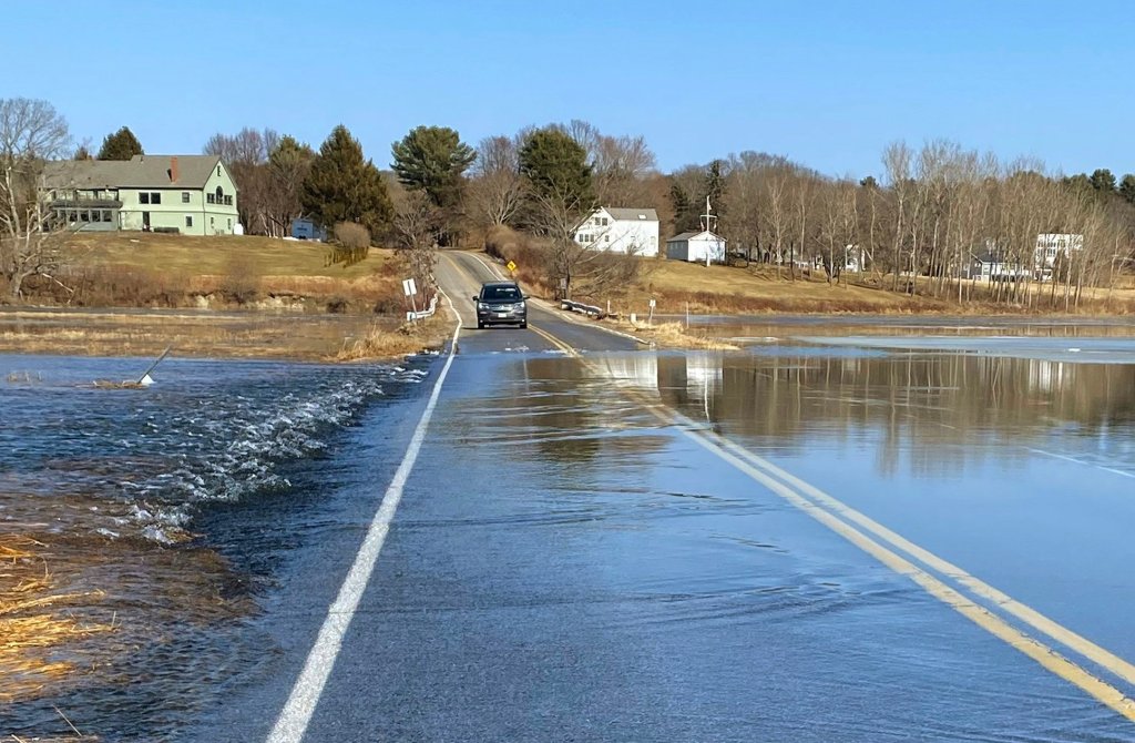
A motorist pauses on the Cape Elizabeth side of the Spurwink Marsh on Feb. 10 before deciding to drive through floodwaters as the Spurwink River flows over Sawyer Road during a rising tide on a storm-free day. Courtesy of Marybeth Richardson
Fixing the road through Spurwink Marsh would cost between $5.5 and $20 million, depending on what the towns decided to do: replace an old, undersized culvert choking 67 acres of upper marsh, spend more to raise the street 7 feet or spend even more to build an elevated causeway to carry cars over a rising sea.
It isn’t clear if the towns could even get the permits to raise the road because Spurwink Marsh is part of the Rachel Carson National Wildlife Refuge and a priority habitat for the endangered salt marsh sparrow, which nests in the high marsh patches where it can find a 24-day flood-free window to hatch its young.
“We’re talking a lot about the road, but for me, I think this is really about an investment in our marsh,” Scarborough Town Councilor Jonathan Anderson said. “The marsh is really integral to who we are as a community and we need to do more to protect it even if (the road) wasn’t getting flooded.”
Earlier this month, town leaders agreed that they would rather save the upper marsh and remove the road – Sawyer Street in Scarborough and Sawyer Road in Cape – and funnel those savings into preparing more heavily traveled roads to face sea level rise, like Cape’s Shore Road or Scarborough’s Black Point Road.
“We didn’t come to this decision lightly,” Scarborough sustainability officer Jami Fitch said. “We’ve got a lot of examples of recent road flooding and we anticipate that flooding will only happen more frequently, be more severe and become more expensive.”
The road removal and marsh restoration project will cost about $2 million. The bulk of that will be spent restoring the marsh, which must be done before the road is removed in early 2027, but it is being funded entirely by a state conservation grant. The towns will have to pay $185,000 each to remove the road.
Town leaders endorsed the project at a joint Feb. 7 workshop, but it won’t begin until the towns approve a memorandum of understanding, budget their local share, accept the $1.6 million state grant, and hold public informational meetings in the spring. (To date, all neighbors support the concept.)
The project is already drawing attention throughout New England.
“This is a restoration project that is significant at a national scale,” said Jeremy Gabrielson, a Cape Town councilor who works as a planner for the Maine Coast Heritage Trust. “For folks involved in tidal marsh restoration, this is a very exciting project. I personally like it because it makes a lot of financial sense.”
All state-funded projects are now required by law to factor future sea level rise into infrastructure design standards – 1.5 feet by 2050 and 4 feet by 2100, according to the Maine Climate Council. And a few, like a $33.5 million bridge project in Woolwich, also are easing tidal restrictions to promote flood prevention.
The Maine Department of Environmental Protection embraced a form of managed retreat in 1985 when it adopted rolling easements to protect dunes from sea level rise and coastal erosion. Rules limit upland development in flood zones, prohibit hard armoring and allow seawall repair only if moved inland.
However, according to coastal managers, no other local or state agency in Maine has adopted “managed retreat” – the strategic relocation of people and infrastructure away from high-risk areas such as wildfire zones or the shoreline – as an official response to climate change.
Scarborough and Cape Elizabeth aren’t using that phrase to describe what they are doing, but both Fitch and O’Meara acknowledge that is what the towns will be doing by removing even a small part of the local network of publicly funded infrastructure.
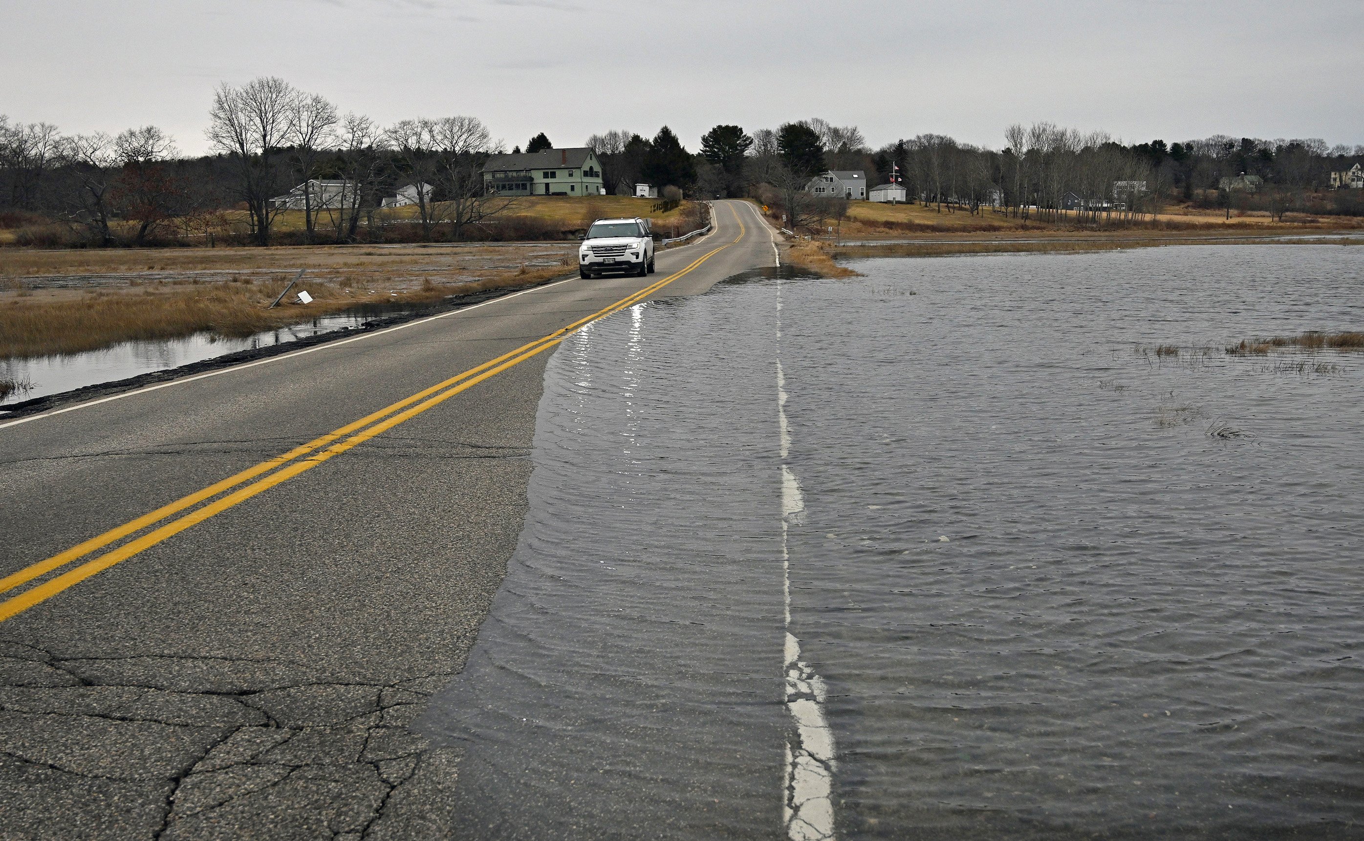
A vehicle crosses Spurwink Marsh at high tide on Tuesday. Shawn Patrick Ouellette/Staff Photographer
Other New England communities like Cranston, Rhode Island, and Scituate, Massachusetts, have used property buyouts to move people out of flood-prone areas. Saco has abandoned a few coastal roads destroyed by storms, but it ignored a 2017 request to seek a government buyout for Camp Ellis homeowners.
Many town leaders say retreat will eventually happen, it’s just a matter of when and if it is planned. The back-to-back-to-back storms in December and January forced many to accept that some beloved places and ways of life may not survive what is coming.
But how do we decide what infrastructure, neighborhoods and natural places should be saved, at least for a little longer, and what should be abandoned? The short answer: no formula can factor in all of the intangibles necessary to come up with an answer that will satisfy everyone.
At Acadia National Park, this thankless balancing act has a name: Thunder Hole.
America’s national parks have adopted a resist-adapt-direct framework to at least start answering that question, Acadia Superintendent Kevin Schneider said. Think of RAD like a climate planner’s Serenity Prayer: protect what you can, but know that not everything can be saved.
Schneider understands that Thunder Hole, the beloved inlet along the park’s rocky eastern shore where turning tides and huge swells produce namesake roars, eventually will be overrun by rising seas. He is already pumping lots of money into every-other-year repairs to the handrail that tourists use to descend to the attraction.
That’s money that Schneider could use to protect other parts of Acadia whose climate fate is not sealed. But it’s also Thunder Hole, the fourth most visited spot (behind Cadillac Mountain, Jordan Pond, and Sand Beach) in New England’s only national park.
“Thunder Hole is Acadia’s version of Old Faithful, a place where generations of families have come to make memories together,” Schneider said. “It can’t last forever. At some point in the future, 10, 20, or even 50 years from now, we’ll have to call it, but we’re not there yet.”
Copy the Story LinkSend questions/comments to the editors.

Success. Please wait for the page to reload. If the page does not reload within 5 seconds, please refresh the page.
Enter your email and password to access comments.
Hi, to comment on stories you must . This profile is in addition to your subscription and website login.
Already have a commenting profile? .
Invalid username/password.
Please check your email to confirm and complete your registration.
Only subscribers are eligible to post comments. Please subscribe or login first for digital access. Here’s why.
Use the form below to reset your password. When you've submitted your account email, we will send an email with a reset code.