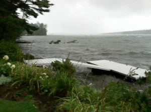
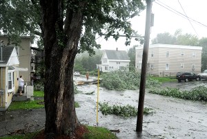
Tropical Storm Irene surged her way through Maine on Sunday, snapping limbs, leveling trees, cutting off power and causing mostly mild mayhem on her way through Vacationland.
But the National Weather Service warned Sunday evening the worst of the once category 3 hurricane was expected overnight Sunday as heavy rains swelled streams, rivers and ponds in western Maine and northern New Hampshire.
“A lot of people forget about these systems after they hit the coast,” NWS meteorologist Mike Kistner said, adding that inland is where weather systems like Irene do some of their worst damage.
Kistner said that while the entire region remained under a tropical storm warning overnight, four counties in Maine and New Hampshire were under flash flood warning until late Sunday night: northern Grafton, northern Carroll, southern Coos in New Hampshire and Oxford County in Maine.
Lacking its earlier mojo but still packing heavy rainfall, Irene caused brooks and streams to rise rapidly on Sunday throughout the region. While the worst of the flooding hit New Hampshire, which saw record amounts of rainfall, Oxford County was one of the hardest hit areas in Maine as many brooks and streams approached flood stage hours before the rains even stopped.
Police, fire departments and highway crews began closing submerged or damaged roads from Rumford to Carrabassett Valley. In Franklin County alone, a bridge washout led to the complete closure of Route 27 in Carrabassett Valley. Throughout the evening, police and emergency crews responded to reports of vehicles getting stuck in rising waters.
“If there is water on the roads, do not try to get through it,” Kistner warned, adding that drivers should never approach roadways covered in water.
In Rumford, Bean Brook shot out of its banks and onto Spruce Street, undermining it in several places and stranding residents in their homes on the east side of the street below Holyoke and Maine avenues.
Resident Diana Casey said that people living on the west side of the street were evacuated. She said one minute the road was clear, and the next Bean Brook was careening down it.
“I’ve lived in Rumford my whole life and never seen anything like this here,” Casey said as she watched in awe while silt-laden brook water raged past her house. “This just blows my mind. I took a walk down to the road and it was like I was on a riverboat. There was nothing here and then, all of a sudden, it just whoomped!”
Kistner said many people mistakenly think that just because the rain stops that their concerns about flash flooding should too. But that is when they should be most concerned because of water runoff coming downstream.
Gusting winds also wreaked havoc with power lines across much of Androscoggin, Oxford and Franklin counties. Statewide, customers in York and Cumberland counties fared worst when it came to power outages, according to Central Maine Power Co. Of the 146,500 homes without power as of Sunday night, more than half were located in Maine’s two southernmost counties.
Combined, about 23,000 homes in Androscoggin, Oxford and Franklin counties were without power as of Sunday night.
Trees fell on a house in Oxford, destroying it and sending two people to a shelter at the American Legion in that town, Allison Hill of Oxford County Emergency Management Agency in Paris said. The two were the only ones reported to be heading to an area shelter.
Lt. Matt Prince of the Sabattus Police Department said the town had a shelter available but that that no one was there as of Sunday evening.
Local authorities, emergency and road crews in the Twin Cities spent much of Sunday afternoon and evening shuttling between reports of trees toppled and wires down. By late Sunday — following several hours of heavy downpours — reports of flooded roadways increased steadily.
“Day shift was pretty steady checking on limbs and power lines and trees down,” Lt. Drew Harrington of the Auburn Police Department said.
Harrington said many of the calls handled by emergency crews during the day Sunday involved minimal damage.
Prince agreed that damage from Irene was not as bad as expected earlier in the week. Like Auburn, authorities in Sabattus also responded to dozens of calls throughout the day, but many caused minimal damage and resulted from downed limbs or power lines.
Kistner expected the worst of the damage to come overnight Sunday from flooding and not necessarily from the wind damage normally associated with hurricanes or tropical storms. His biggest concern stemmed from earthen dams throughout the region.
As of Sunday afternoon, more than 10 inches of rain had fallen in the White Mountains in New Hampshire and many areas were averaging about three inches per hour. As of late Sunday afternoon, about four inches of precipitation had fallen in Androscoggin and Franklin counties, according to the National Weather Service, while Irene dumped nearly six inches on Oxford County and neighboring New Hampshire.










Comments are no longer available on this story