
[media-credit name=”NWS map” align=”aligncenter” width=”850″]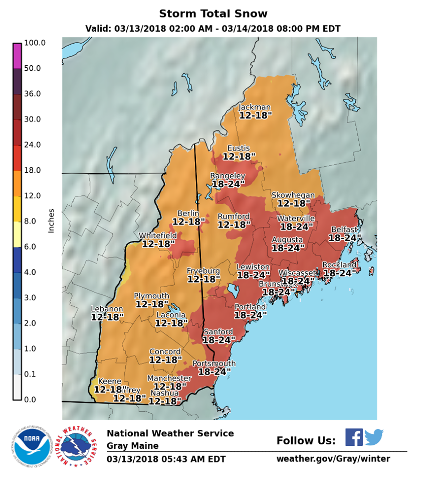 [/media-credit]
A blizzard warning was issued early Tuesday as the second nor’easter in a week surges into Maine.
Snow began falling before dawn in York County and will overtake southern Maine during the morning commute. Snow will reach midcoast and central Maine by mid-morning and continue to fall well into Wednesday.
Blizzard conditions are possible this afternoon, when snow could fall an inch an hour and winds are expected to gust to 50 mph. The storm will peak Tuesday afternoon.
The storm is expected to dump 18 to 24 inches of snow over much of the state just five days after a storm blanketed Portland in 15.7 inches of snow. The National Weather Service is predicting 19 inches of snow will fall in Portland by the time the storm wraps up, an increase of about 3 inches from predictions leading up to the storm.
“From 11 this morning to 2 a.m. (Wednesday), the worst conditions will be occurring. We’re looking at winds gusting in Portland as high as 50 mph,” said John Cannon, a meteorologist with the weather service office in Gray. “That might cause white-out conditions with blowing snow. It’s going to be pretty nasty.”
Schools and town offices across southern and central Maine are closed for the second time in a week because of snow. Banks, medical offices and child care centers also announced they would again be closed for the day.
Courts across Maine are closed, legislative work sessions and hearings have been called off and Meals on Wheels recipients are being advised to use their storm packs.
A full list of closings and cancellations is available here.
The forecast prompted widespread cancellations and suspension of transportation on Tuesday, including at the Portland International Jetport, by Concord Coach Lines and the Amtrak Downeaster. The Greater Portland Transit District announced Metro bus service will shut down at 10 a.m. Tuesday.
The speed limit has been reduced to 45 mph for the entire length of the Maine Turnpike.
The snow is not supposed to be as wet and heavy as the snow that fell last Thursday, which could cause treacherous travel conditions. A fluffier snow will blow around, limiting visibility and creating whiteout conditions when winds gusts.
The weather service issued a blizzard warning from 11 a.m. to 2 a.m. Wednesday for seacoast New Hampshire and coastal York, Cumberland and Sagadahoc counties in Maine. Blizzard conditions occur when there are three consecutive hours of snow with 35 mph winds and visibility of a quarter-mile or less.
Travel during blizzard conditions is dangerous and should be avoided, according to the weather service.
A winter storm warning is in effect for the entire state.
The U.S. Coast Guard in Boston warned mariners that conditions at sea will become extremely dangerous on Tuesday.
“Operation for any craft in the maritime environment will be dangerous, as there is high marine impact expected with 45-to-60-knot wind gusts and 20-foot seas,” the Coast Guard said in a statement.
Bob Marine, a meteorologist with the National Weather Service in Gray, said the weather system that will usher in today’s storm is part of a repeating pattern, in which the jet stream lines up just right to drive cold air from the West Coast to the Eastern Seaboard. The system gets shots of energy from the cold air off the mid-Atlantic states and coastal low-pressure systems develop. Sometimes the pattern is short-term and sometimes it can last a month. It can also break down very quickly.
“One moves out and the next one moves in,” Marine said. “This series is about every four to seven days. We’re just on the wrong side of it.”
According to the weather service, 75.5 inches of snow has been recorded in Portland this winter, which is 23.2 inches above the seasonal average of 52.3 inches. Before Tuesday, 17.3 inches of snow had fallen in March.
That may seem like a lot of snow for the month when spring begins, but Portland has a long way to go before breaking any records. In March 1993, 49 inches of snow fell in Portland. The second snowiest March on record occurred in 1956, when 46.6 inches fell in the city.
The late winter snowstorms prompted National Weather Service meteorologist Chris Kimble to go digging into some ancient weather data. Record-keeping began in October 1881.
“Looking at the list of the biggest March snowstorms in Portland we came across something ominous. Of the top 10 biggest March snowstorms, four of them have occurred on March 13 and 14,” Kimble wrote in a Facebook post over the weekend.
The biggest March snowstorm in Portland was 21.9 inches set on March 12-14, 1939, followed by 18.6 inches on March 13 and 14 in 1993. A total of 16.4 inches of snow fell in Portland on March 14-15 in 2017 – the sixth largest March storm on record.
This story will be updated.
Comments are no longer available on this story