
BLIZZARD WARNING
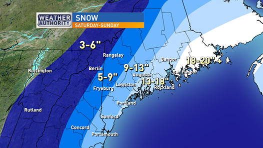
Blizzard Warnings have been issued from noon today through early Monday morning. The storm is a clipper system approaching from the northwest this morning. It will intensify rapidly over the weekend as it track to our south and east. Snow will over spread our skies during the afternoon today. Initially the intensity will be light but will pick up during the night time hours. Our heaviest bands of snow are expected to move in between 6PM Saturday and 1PM Sunday. I don’t anticipate strong winds on today but gusts may approach 20 mph this evening. Winds will be at their strongest on Sunday which will produce significant blowing and drifting. It’s still looking like most of the area will pick up one to two feet of snow with the highest amounts at the coast. Totals may eclipse 2 feet Downeast. Significant blowing and drifting should be expected on Sunday providing limited visibilities and huge snow drifts.
Monday will be a brighter day and a good day to dig out. More snow is possible mid-week but that one does not look to be a major storm. Stay tuned.
Charlie Lopresti-Chief Meteorologist
HERE’S WHAT YOU CAN EXPECT FROM THE WEEKEND STORM
TIMING: Light snow develops this afternoon but the main event with heavy snow should arrive tonight through mid-day Sunday. Heaviest snowfall should be between 6PM tonight and 1PM Sunday. Snow should lighten up and end during the evening Sunday.
TYPE: All snow is expected. Much like the last several storms, this one will likely feature fluffy, but also windblown snow.
HOW MUCH: Most of the area should expect one to two feet of snow. Highest amounts will be along coastal areas. Stay updated on changes.
WINDS: Wind will play a major role in this storm on Sunday. I don’t anticapate any wind related problems Saturday but gusts of 40 to 55 mph are likely Sunday. Blowing and drifting snow will be big variables Sunday. Strongest winds are expected along the coast and over the higher elevations.
WHAT DOES A BLIZZARD WARNING MEAN? As of Thursday evening NWS has issued Blizzard Watches and Winter Storm Watches but those will likely be converted to Blizzard Warnings and Winter Storm Warnings on Friday. A Blizzard Warning is issued when the following conditions are expected. Visibility reduced to ¼ mile or greater due to falling or blowing snow, winds sustained or frequent gusts to 35 mph or more, and happening for 3 hours or more. Based on today’s forecast, those conditions should be met for a large portion of the area by Sunday morning.
POWER OUTAGES: Power outages are possible but most likely not widespread. The reason is the consistancy of the snow being so light and fluffy. It shouldn’t stick to the trees and wires and any weak branches most likely already broke in freezing rain storms earlier in the winter.
COASTAL FLOODING: Coastal flooding, beach erosion and splashover is possible at the times of high tides Saturday night through Sunday. The tide to watch will be 7:14 AM high tide (Portland) Sunday morning which is at 9.4’. A Coastal Flood Warning has been issued Sunday morning.
Lew. Parking Ban In Effect from 11 p.m. Saturday (2/14) Until 7 a.m. Monday (2/16). All Lewiston city parking garages are free all weekend.
– The City of Auburn is implementing a parking ban for the pending winter storm expected to start tomorrow. The parking ban will begin at 12:01am on Sunday 02/15/15 and will last until 11:59pm on Sunday 02/15/15.
————————————-
Maine Turnpike: Speeds are now reduced from the NH State Line to Augusta due to snow, please travel with caution.
——————————————–
Amtrak Downeaster: Due to the severe weather predicted, all Downeaster trains have been canceled for Sunday, Feb. 15th.
———————————————–
Portland International Jetport: All of our inbound flights tonight have been cancelled. Majority of flights tomorrow have been cancelled.
LOCAL SPORTS:
AUGUSTA – For the second consecutive year, the boys’ basketball teams from Lewiston and Edward Little will have to wait until Monday to play their quarterfinal games at Augusta Civic Center.
Saturday night’s blizzard warnings have forced postponement of the Lewiston-Cony and Edward Little-Brewer games scheduled for 8 and 9:30 p.m., respectively.
The games now will be played as a Monday morning session, with Lewiston taking the court at 10 a.m. and EL at 11:30 a.m.
Class C quarterfinal game times scheduled for Monday remain unchanged. The afternoon session will begin at 2:30 p.m., and the evening session starts at 7 p.m.
Due to the changes, Tuesday becomes an eight-game, single-admission day at the civic center, beginning at 10 a.m.
The two Class D West girls’ quarterfinals scheduled for Monday will move to Tuesday after the originally scheduled games. That will push back the start of the Class C quarterfinals to 4 p.m.
MONDAY
Class A boys – Lewiston vs. Cony, 10 a.m.; Edward Little vs. Brewer, 11 p.m.
Class C boys – Waynflete vs. Hall-Dale, 2:30 p.m.; Dirigo vs. Old Orchard Beach, 4 p.m.; Winthrop vs. Madison, 7 p.m.; Boothbay vs. Maranacook, 8:30 p.m.
TUESDAY
Class D girls – Richmond vs. Hyde, 10 a.m.; Pine Tree vs. Vinalhaven, 11:30 a.m.; Forest Hills vs. Searsport, 1 p.m.; Rangeley vs. Valley, 2:30 p.m.
Class C girls – Dirigo vs. Monmouth, 4 p.m.; Boothbay vs. Madison, 5:30 p.m.; Old Orchard Beach vs. Mountain Valley, 7 p.m.; Maranacook vs. Carrabec, 8:30 p.m.

Comments are no longer available on this story