

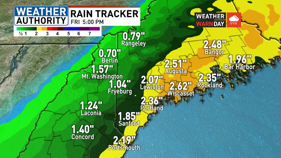
Heavy rain, up to 3-4 inches, expected especially towards the coast Thursday and into Friday. This will lock in either wettest or second wettest March on record. WGME graphic
Thursday’s rain will continue into Friday and fall on the snowpack — leading to significant melt. The combination of rain and snowmelt will increase flows in rivers and streams, some of which could reach critical levels.
The National Weather Service has issued a flood watch for much interior Maine — including Androscoggin County.
While the rain likely wraps up Friday morning, there are some indications it could end up extending into the afternoon.
The rain may change over to snow in the mountains and even for areas outside of the higher elevations early Friday. The best chance of accumulation will be in the mountains.
DRIER WEEKEND
Things do finally dry out for the weekend. Saturday looks nice and sunny, but a bit breezy with highs near 50.
A weak clipper system moves through late Saturday night. A round of light snow will be possible in southern and western Maine with a quick coating of snow possible heading into Sunday morning.
But Sunday also looks pretty nice. Clouds move out in the morning and any light dustings of snow will melt fast. Highs will be again near 50 with plenty of afternoon sun.
Monday continues with sunny and quiet weather. Temps will be in the lower 50s for the afternoon.
NOR’EASTER NEXT WEEK
A significant winter storm potential exists for the Tuesday-Thursday time frame next week. A nor’easter looks to develop and linger near Maine for at least two full days. Heavy snow, heavy rain, and coastal issues are all possible with this. It could end up being a significant April snowstorm.
Copy the Story LinkSend questions/comments to the editors.

Success. Please wait for the page to reload. If the page does not reload within 5 seconds, please refresh the page.
Enter your email and password to access comments.
Hi, to comment on stories you must . This profile is in addition to your subscription and website login.
Already have a commenting profile? .
Invalid username/password.
Please check your email to confirm and complete your registration.
Only subscribers are eligible to post comments. Please subscribe or login first for digital access. Here’s why.
Use the form below to reset your password. When you've submitted your account email, we will send an email with a reset code.